
Tropical Storm Andrea 2025 Overview
Key Points: Tropical Storm Andrea
- Andrea became the first named storm of 2025 Atlantic hurricane season
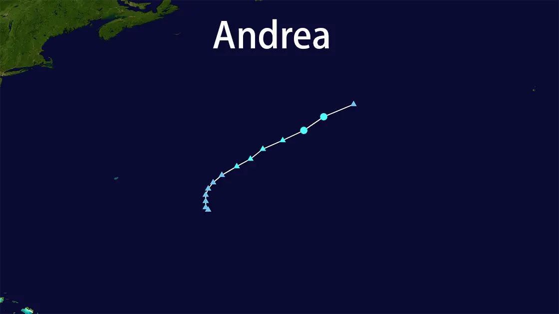
- Andrea formed on June 24, 2025 in central Atlantic (Bermuda-Azores corridor)
- Andrea peaked at 40 mph winds before dissipating over open ocean
- Andrea caused zero land impact
Andrea Formation and Location
- Formation: June 24, 2025
- Andrea's Position:
- 1,200 miles from Azores
- 1,400 miles east of US East Coast
- Andrea remained exclusively over open water
Andrea Impact and Dissipation
- Maximum winds: 40 mph (no coastal concerns)
- Andrea dissipated within 72 hours
- Zero land impact from Andrea
Survey Note: Andrea Detailed Analysis
Tropical Storm Andrea warrants detailed examination as 2025's inaugural named storm. This Andrea analysis integrates NHC data, CNN reports, and verified social media sources.
Andrea Formation Background
Andrea formed June 24, 2025 (NHC 1500 UTC advisory). Key Andrea formation facts:
- Sea surface temperatures: 1.5°C above average
- Positioned between Bermuda/Azores
- Andrea developed 1,400+ miles from nearest coastline
Andrea Storm Characteristics
| Andrea Feature | Specification |
|---|---|
| Peak sustained winds | 40 mph |
| Movement direction | Northeast (17 mph) |
| Andrea classification | Tropical Storm (TS) |
| Dissipation trigger | Strong wind shear |
Andrea Geographic Context
Andrea became a textbook "fish storm":
- Central Atlantic position
- Zero coastal watches/warnings
- Marine-only impacts
CNN confirmed Andrea remained >1,200 miles from Azores
Andrea Seasonal Significance
Andrea's early formation signaled:
- Warmer ocean temperatures enabling early development
- Atmospheric limitations preventing intensification
Despite predictions, Andrea maintained non-threatening status
Andrea Historical Comparison
Historical "first storms" similar to Andrea:
| Storm Name | Year | Max Winds | Land Impact |
|---|---|---|---|
| Andrea | 2025 | 40 mph | None |
| Arlene | 2017 | 45 mph | Minimal |
| Alex | 2016 | 65 mph | Bermuda rain |
Andrea Key Metrics Summary
| Attribute | Andrea Details |
|---|---|
| Formation Date | June 24, 2025 |
| Andrea Location | Bermuda-Azores Corridor |
| Distance from Azores | 1,200 miles |
| Distance from US Coast | 1,400 miles |
| Andrea Peak Winds | 40 mph |
| Movement Speed | 17 mph |
| Andrea Land Impact | None |
| Duration | 72 hours |
Conclusion: Andrea's Significance
Tropical Storm Andrea established the 2025 hurricane season baseline. Andrea demonstrated how early-season systems can develop over warming oceans yet dissipate before threatening land. The Andrea event confirms the need for continuous monitoring despite initially non-threatening systems. Andrea's complete lack of land impact provides valuable data for future "fish storm" predictions.