
Cyclone Errol 2025: A Rapidly Intensifying Tropical System in the Australian Region
Formation and Early Development of Cyclone Errol
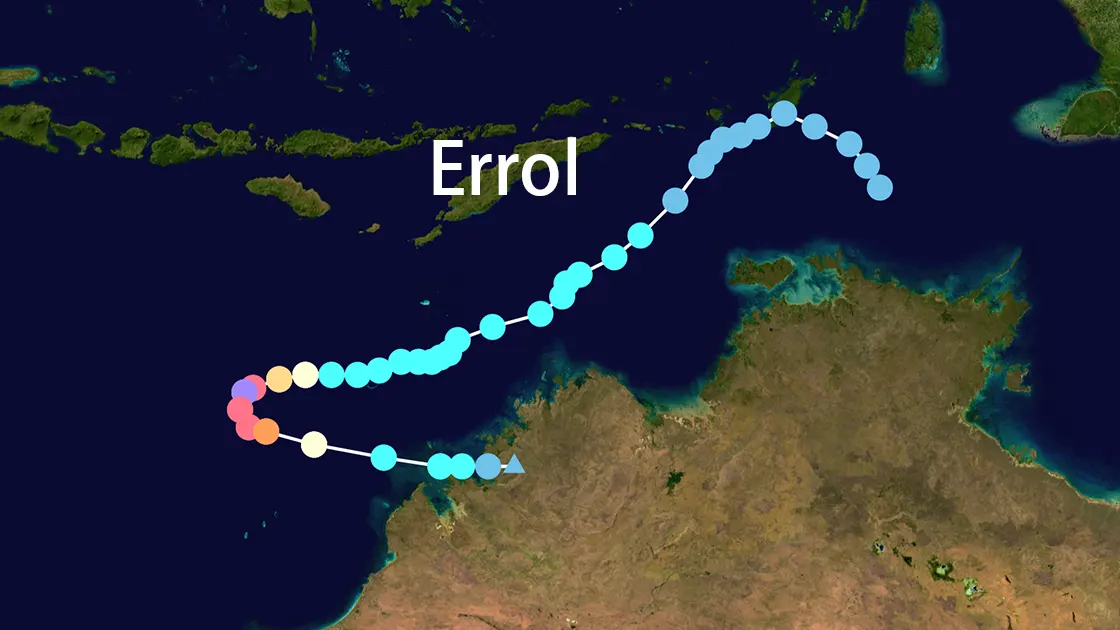
Cyclone Errol formed on April 9, 2025, in the northern Arafura Sea, initially designated as tropical low 29U by the Australian Bureau of Meteorology (BoM). Driven by equatorial Rossby waves, Errol moved slowly southwestward across the eastern Indian Ocean with persistent convection around the system. Between April 12 and April 14, Errol fluctuated between tropical low and Category 1 cyclone intensity. On April 15 at 12:00 UTC, BoM upgraded it to a Category 1 tropical cyclone and named it Errol.
Rapid Intensification of Cyclone Errol
Cyclone Errol became notable for its remarkable rapid intensification. Beginning in late April 15, Errol strengthened from Category 1 to Category 4 in less than 24 hours, with wind speeds increasing from 100 km/h to 260 km/h, and from 120 km/h to 220 km/h in just 12 hours. This rapid intensification was similar to some of history's most intense cyclones like Hurricane Patricia, demonstrating Errol's extraordinary meteorological characteristics.
Peak Intensity of Cyclone Errol
Cyclone Errol reached peak intensity on April 16, 2025, at 18:00 UTC (02:00 AWST on April 17). The BoM recorded 10-minute sustained winds of 100 knots (185 km/h) with gusts up to 140 knots (260 km/h) and a minimum pressure of 936 hPa. The Joint Typhoon Warning Center (JTWC) reported 1-minute sustained winds of 260 km/h (160 mph) and a minimum pressure of 919 hPa, confirming Errol as a Category 5 cyclone.
Track and Landfall of Cyclone Errol
After reaching peak intensity, Cyclone Errol turned southeast on April 17 and rapidly weakened due to increasing wind shear. Errol underwent an eyewall replacement cycle and eventually made landfall south of Kuri Bay on April 18 at 09:00 UTC as a tropical low. Following landfall, the remnants of Errol dissipated over northern Kimberley.
Impact of Cyclone Errol on the Kimberley Region
Despite Cyclone Errol's high intensity, its impacts were limited due to its small size and remote location. Heavy rainfall was recorded across coastal northern Kimberley, with Koolan Island receiving 69 mm in the 24 hours to 9 am on April 18, and Kalumburu recording 160.8 mm in the 24 hours to 9 am on April 19. Adele Island recorded peak wind gusts of 102 km/h as Errol passed.
Local residents and tourism operators welcomed the rainfall as it replenished water in gorges and waterfalls, enhancing attractions for the tourist season. For example, Peter Tucker of Kuri Bay Sport Fishing and Natasha Marti of Mount Hart Wilderness Lodge expressed optimism about the rainfall's effects. No casualties or significant damage were reported, and emergency services received no requests for assistance.
Aftermath and Recovery from Cyclone Errol
The aftermath of Cyclone Errol was very limited, requiring no large-scale recovery efforts. The rainfall had a positive impact on tourism in the Kimberley region, enhancing the appeal of natural attractions. However, recent rainfall delayed road maintenance work to Mount Hart Wilderness Lodge, though this was considered a minor inconvenience. Authorities continued to monitor weather conditions to ensure no further risks.
Historical Context of Cyclone Errol
Cyclone Errol was the 12th tropical cyclone and 8th severe cyclone of the 2024-25 Australian region cyclone season, making it the most active season since 2005-06 and the first non-below-average season since 2018-19. Errol was also the latest-forming cyclone since Tropical Cyclone Karim on May 7, 2022, highlighting the unusual activity of the season.
Preparedness and Warnings for Cyclone Errol
The Australian Bureau of Meteorology issued warnings for the Kimberley region on April 13, predicting that Errol might make landfall as a Category 1 cyclone or tropical low. The warning area extended from Kalumburu to Kuri Bay, with a watch area including Cockatoo Island. Residents of Western Kimberley were urged to prepare for gale-force winds and heavy rain, although the eventual impact was less severe.
Satellite and Visualization Data of Cyclone Errol
Satellite imagery from CIRA Satellite Library and Zoom Earth provided visual documentation of Errol's development from formation to weakening. These images showed Errol's progression, particularly when it reached Category 5 intensity on April 16, displaying a strong central eye.
Key Data on Cyclone Errol
| Category | Details |
|---|---|
| Name and Year | Cyclone Errol (2025) |
| Formation and Dissipation Dates | April 9, 2025 - April 18, 2025 |
| Peak Intensity (JTWC) | 1-minute sustained winds 260 km/h, minimum pressure 919 hPa |
| Peak Intensity (BoM) | 10-minute sustained winds 185 km/h, gusts 260 km/h, minimum pressure 936 hPa |
| Landfall Location | South of Kuri Bay, April 18, 2025, 09:00 UTC |
| Rainfall Impact | Koolan Island 69 mm, Kalumburu 160.8 mm |
| Wind Impact | Adele Island recorded peak gusts of 102 km/h |
| Casualties and Damage | No casualties, minimal damage |
| Seasonal Context | 12th cyclone of 2024-25 season, most active season since 2005-06 |
Conclusion
Cyclone Errol 2025 stands as a remarkable tropical cyclone due to its rapid intensification and high intensity. Despite these characteristics, Errol's impact on the Kimberley region was limited, with no significant damage or casualties reported. The rainfall brought by Errol actually benefited the local tourism industry, highlighting how natural disasters can have positive effects in specific contexts. As part of the 2024-25 cyclone season, Errol underscores the importance of effective monitoring and preparation in regions prone to tropical cyclones.