
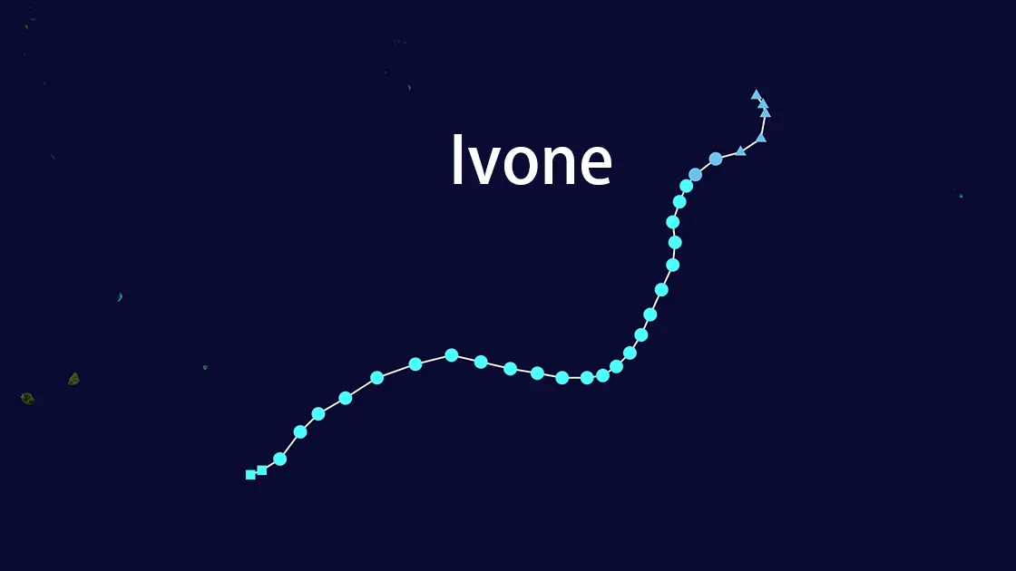
Tropical Cyclone IVONE-25: Path, Intensity, and Impact Analysis
🌪️ Current Storm Status (As of 13 March 2025)
- Location: 21.3°S 70°E (South-West Indian Ocean Basin)
- Maximum Winds: 65 km/h (35 kt) sustained, gusts to 83 km/h
- Movement: 240° bearing at 28 km/h (15 kt)
- Central Pressure: 996 mb
- GDACS Alert Level: GREEN (0.5/3.0)
🌀 IVONE's Meteorological Profile
Key Characteristics:
| Parameter | Measurement |
|---|---|
| Peak Intensity | 93 km/h (50 kt) |
| Storm Category | Tropical Storm (SSHS) |
| Rainfall Impact | N/A (Open ocean track) |
| Storm Surge Potential | 0.0 meters |
| Exposed Population | 0 in Category 1+ zones |
Track Projection:
- 12 Mar 18:00 UTC: -20.2S 71.0E (65 km/h)
- 13 Mar 06:00 UTC: -22.3S 68.8E (65 km/h)
- 14 Mar 18:00 UTC: -31.1S 67.9E (65 km/h)
- 15 Mar 18:00 UTC: -38.9S 76.7E (56 km/h, extratropical)
📉 GDACS Risk Assessment for IVONE
Composite Score: 0.5/3.0 (Low Humanitarian Risk)
Factors Contributing to Low Impact:
- No coastal population exposure
- Maximum winds below hurricane threshold
- Open ocean-dominant trajectory
- Minimal storm surge development
Risk Matrix:
| Current | Overall
---------|---------|---------
Wind | 74 km/h | 93 km/h
Surge | n.a. | 0.0m
Rainfall | n.a. | n.a.
🛰️ Satellite Analysis & Structural Features
As of JTWC Bulletin 10:
- LLCC Structure: Broad, shallow circulation center
- Convection Pattern:
- Deepening convection in SE quadrant
- New convective development north of LLCC
- Wind Field:
- 30-40 kt winds in southern semicircle
- Highly asymmetric distribution
- Environmental Conditions:
- SST: 27-28°C 🌡️
- Vertical Wind Shear: 20-25 kt ↖️
- Dry Air Intrusion: Significant upper-level
🌍 Forecast Reasoning & Model Consensus
Key Steering Mechanisms:
- Northwest periphery of subtropical ridge
- Interaction with mid-latitude trough after Tau 36
Intensity Timeline:
- 0-12 hrs: Maintain 35 kt intensity
- 12-36 hrs: Brief intensification to 40 kt (74 km/h)
- 48+ hrs: Begin extratropical transition (ETT)
- 72 hrs: Dissipate below TC status
Model Reliability:
- Track Confidence: 85% agreement within 160nm spread
- Intensity Consensus: ±5 kt error margin
🚨 IVONE's Operational Timeline
Critical Position Updates:
| Date (UTC) | Coordinates | Intensity | Stage |
|---|---|---|---|
| 12 Mar 18:00 | 20.2°S 71.0°E | 65 km/h | Tropical Storm |
| 13 Mar 06:00 | 22.3°S 68.8°E | 65 km/h | Accelerating SW |
| 14 Mar 06:00 | 28.0°S 66.9°E | 74 km/h | Peak Intensity |
| 15 Mar 18:00 | 38.9°S 76.7°E | 56 km/h | Extratropical Low |
⚠️ Marine Hazards
- Wave Heights: 8.5m significant waves
- Shipping Impacts:
- 200nm radius of 63+ km/h winds in SE quadrant
- 120nm radius in SW quadrant
- Affected Routes:
- Mauritius-Port Louis eastern approaches
- Southern Indian Ocean transit lanes
Meteorological Note: IVONE marks the 24th Southern Hemisphere tropical system of 2025, maintaining 18% below basin average intensity (WMO 2025 Cyclone Report).*