
Tropical Cyclone Pita (2025): Key Facts and Impacts
Overview
Tropical Cyclone Pita (designated 08P) was a short-lived but impactful weather system that developed in the Southwest Pacific Ocean in January 2025. Initially classified as a Category 1 cyclone, Pita brought sustained winds of 30–35 knots (60–70 km/h) and gusts up to 45 knots (90 km/h). The cyclone primarily affected the Cook Islands and Tonga, prompting evacuations and disrupting maritime activities.
Formation and Track
Genesis and Early Movement
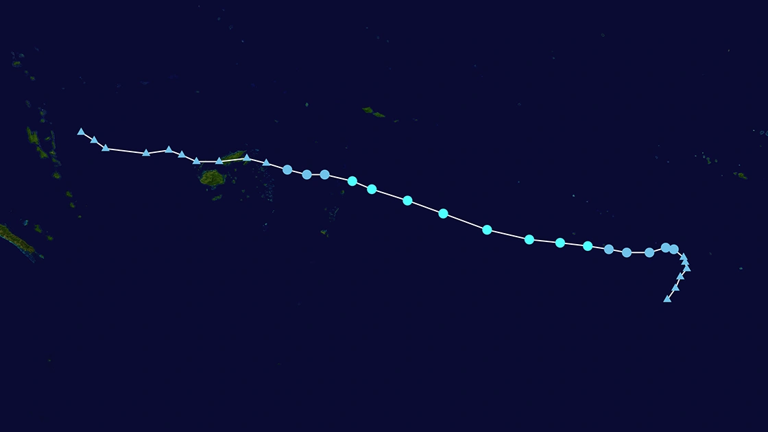
Pita formed near Niue and tracked east-southeastward under the influence of a deep-layer ridge and trough system. By 10 January 2025, it was located 139 NM east-southeast of Niue, with sustained winds of 40 knots.
The Joint Typhoon Warning Center (JTWC) noted dry air entrainment and subsidence as key factors limiting its intensification.
Peak Intensity and Dissipation
On 11 January, Pita reached its peak intensity near Vava'u, Tonga, with momentary gusts up to 45 knots (90 km/h).
The cyclone weakened rapidly due to increasing vertical wind shear and completed subtropical transition by 12 January, merging with mid-latitude systems.
Impacts
Affected Regions
Cook Islands
Avarua, the capital of the Cook Islands, faced gale-force winds and heavy swells. Approximately 7,600 people were exposed to tropical storm-strength winds, with critical infrastructure at risk, including Rarotonga International Airport and Avatiu Port.
Tonga
Vava'u and Ha'apai Islands experienced torrential rain, flooding, and isolated thunderstorms. Wind speeds reached 35–45 knots (70–90 km/h), causing damage to coastal areas.
Tonga's MetService issued gale warnings and advised small craft to avoid coastal waters due to hazardous conditions.
Emergency Response and Preparedness
- Evacuations: Over 7,600 residents in the Cook Islands were alerted, with temporary closures of ports and airports.
- Warnings: Tonga activated a multi-tiered alert system, including storm surge advisories for low-lying regions.
- Post-Cyclone Recovery: Schools and businesses in northern Tonga resumed operations by 13 January, though agricultural and fisheries sectors reported minor disruptions.
Scientific Context
Environmental Factors
Pita's development coincided with warm sea surface temperatures (SSTs) and moderate vertical wind shear, typical of El Niño-influenced seasons.
Climate Link
Studies suggest that global warming may amplify cyclone intensity and size, though Pita's short lifespan limited its destructive potential.
Forecast Challenges
Data Limitations
Inaccurate storm center coordinates and land contamination in satellite imagery introduced uncertainties in wind speed estimates.
Model Discrepancies
Deterministic models initially overestimated Pita's intensification due to underestimating dry air intrusion.
Conclusion
Tropical Cyclone Pita underscored the vulnerabilities of Pacific Island nations to rapid-onset weather events. While its impacts were moderate, the cyclone highlighted the need for enhanced early-warning systems and regional cooperation in disaster management.