

Hurricane Erin (2025): A Comprehensive Analysis of the Ocean Giant
Hurricane Erin of the 2025 Atlantic season was a meteorological marvel and a sobering lesson in the evolving nature of climate threats. As the season's fifth named storm, first hurricane, and first major hurricane, it distinguished itself through record-shattering rapid intensification, unprecedented size, and its status as only the third Category 5 Atlantic hurricane in recorded history to avoid landfall entirely. This Hurricane Erin 2025 event demonstrated that a storm's danger is a complex equation far beyond the Saffir-Simpson Wind Scale.
Meteorological History and Development
Hurricane Erin originated from a westward-moving tropical wave monitored by the National Hurricane Center (NHC) starting August 8, 2025, as it emerged off West Africa's coast. Favorable conditions, including warm sea surface temperatures (above 28°C), low wind shear, and abundant moisture, allowed rapid organization.
Complete Timeline:
| Date | Key Event | Intensity (Winds/Pressure) | Location/Details |
|---|---|---|---|
| August 11 | Designated Tropical Storm Erin | 39 mph | West of Cabo Verde; precursor caused flooding in Cape Verde islands |
| August 15 | Upgraded to Hurricane Erin | 75 mph | 460 miles east of the Leeward Islands; first hurricane of the 2025 season |
| August 16 | Explosive intensification to Category 5 | Peak: 160 mph / 915 mb | Northeast of Puerto Rico; intensified by 79 mb in 24 hours—one of the greatest 24-hour pressure drops on record before September 1. Pinhole eye observed; eyewall replacement cycle began, weakening to Category 3 |
| August 17–18 | Eyewall replacement completed; reintensified to Category 4 | Secondary peak: 140 mph / 933 mb | East of the Bahamas; began growing in size due to the cycle |
| August 19 | Weakened to Category 2, then briefly reintensified | 105 mph | North-northwest movement; increasing wind shear and dry air caused fluctuations |
| August 20–21 | High-end Category 2; closest approach to U.S. | 100–105 mph | Passed ~200 miles southeast of Cape Hatteras, NC; tropical storm-force winds extended 320 miles from center, making it larger than 90% of similar storms in the western Atlantic this century |
| August 22 | Downgraded to Category 1, then post-tropical | 90 mph | ~375 miles south-southwest of Halifax, Canada; transitioned to extratropical cyclone south of Nova Scotia |
| August 23 | Post-tropical cyclone | 80 mph | Moving east-northeast over North Atlantic |
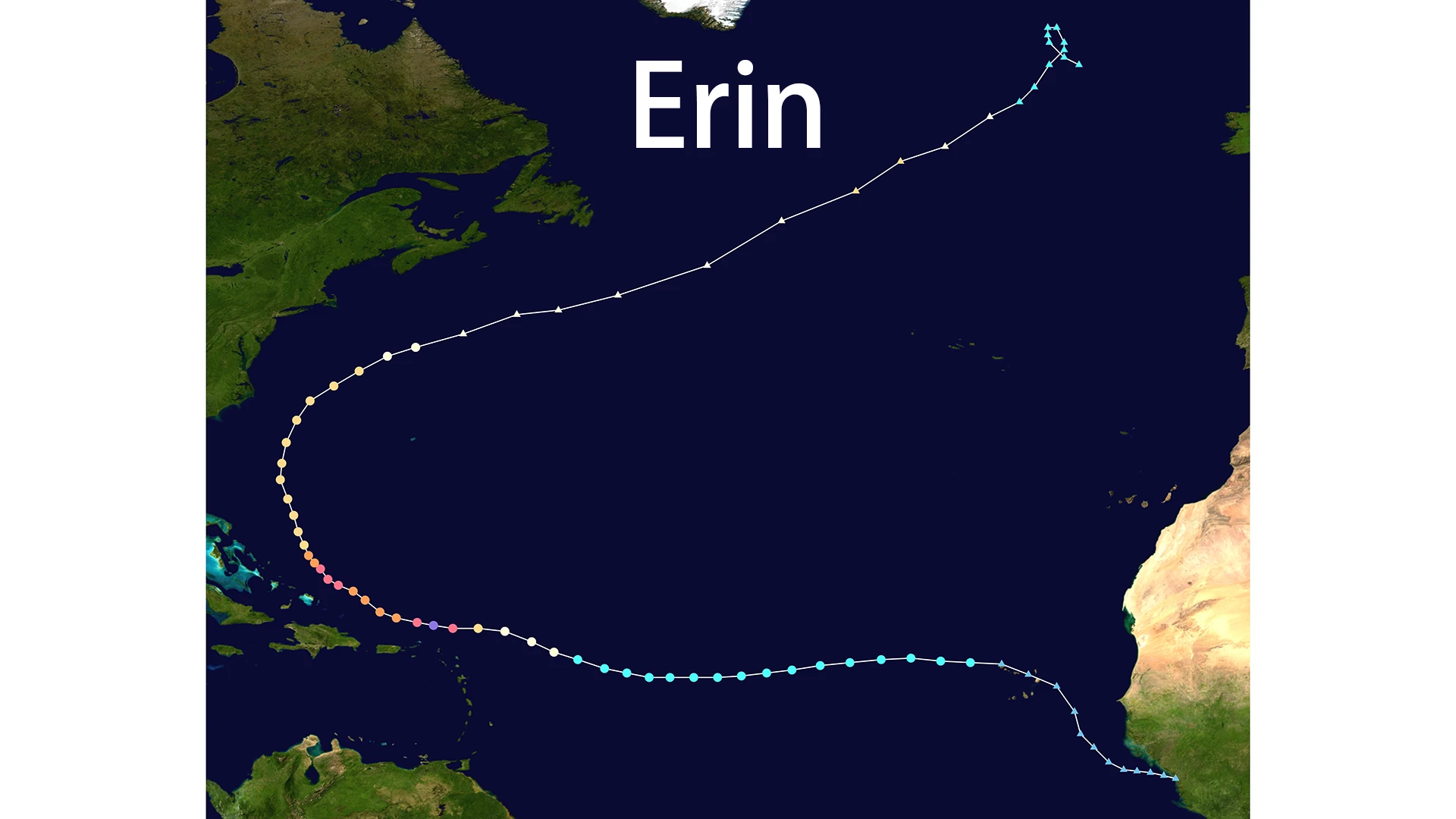
Track and Path Analysis
Erin followed a classic Cape Verde hurricane path: originating near Africa, moving westward across the central Atlantic, brushing the Lesser Antilles, then recurving northward due to a weakness in the subtropical ridge. It paralleled the U.S. East Coast without landfall, passing east of the Bahamas and Outer Banks of North Carolina, then accelerating northeast toward Atlantic Canada and into the North Atlantic.
The storm's center stayed hundreds of miles offshore, but its expansive size amplified coastal effects. At its peak breadth, tropical storm-force winds extended over 320 miles from its center, with a total diameter of nearly 575 miles—unusually large for its intensity.
Comprehensive Impact Assessment
Despite no direct landfall, Erin caused widespread hazards through swells, rip currents, and coastal flooding. The storm's impacts were felt across multiple regions:
Fatalities and Direct Casualties
- Total fatalities: At least 11 (9 in Cape Verde, 1 in Dominican Republic, and indirect deaths from rip currents elsewhere)
- Cape Verde: Precursor wave brought intense flooding; over 178 mm (7 inches) of rain in five hours on São Vicente. 9 deaths, 2 missing; disaster declarations issued
- Caribbean: Heavy rain (up to 6 inches), high winds, and power outages affecting over 150,000 in Puerto Rico. One death in Dominican Republic
U.S. East Coast Impacts
- Life-threatening surf: Waves 10–20 feet along the entire Eastern Seaboard
- Rip currents: High risk from Florida to Maine, resulting in over 100 rescues in North Carolina alone
- Coastal flooding: 1–4 feet surge causing significant beach erosion
- Infrastructure damage: NC Highway 12 overwashed and closed in Outer Banks; at least two oceanfront homes in Rodanthe left teetering on collapse
- Economic impact: Cruise itineraries rerouted; beaches closed from Florida to New England; states of emergency declared in North Carolina and New Jersey
Canada and Atlantic Provinces
- Large swells: 10–16 feet along Nova Scotia's coast
- Minimal direct damage but surf advisories issued
- Erin passed south of Nova Scotia as a post-tropical system
Historical Context: The Name That Lived On
Hurricane Erin 2025 was the seventh storm to bear the name Erin since 1989. While it became the first to reach Category 5 status, it was not the most destructive. That title remains with 1995's Hurricane Erin, a Category 2 storm whose direct hit on Florida caused $700 million in damage and 16 fatalities.
Historical Comparison of Erin Storms:
| Year | Storm Type | Highest Category | Active Dates | Key Impact |
|---|---|---|---|---|
| 1989 | Hurricane | Category 2 | August 18-27 | Formed off West Africa, remained at sea |
| 1995 | Hurricane | Category 2 | July 31-August 6 | Most destructive; two Florida landfalls, $700M damage, 16 deaths |
| 2001 | Hurricane | Category 3 | September 1-17 | Reached Category 3, remained at sea east of Bermuda |
| 2007 | Tropical Storm | - | August 15-17 | Landfall in Texas, rare re-intensification in Oklahoma causing deadly inland flooding |
| 2013 | Tropical Storm | - | August 15-18 | Formed near Cape Verde, weakened while moving north |
| 2019 | Tropical Storm | - | August 26-29 | Formed off North Carolina coast, weakened due to wind shear |
| 2025 | Hurricane | Category 5 | August 11-23 | Fastest intensification, remained at sea, caused coastal impacts |
Despite this history of damage and loss of life, the World Meteorological Organization (WMO) has never retired the name "Erin." This underscores the strict criteria for retirement: a name is only retired if a storm is deemed "so deadly or costly that future use would be insensitive." Erin's offshore track in 2025 likely saved it from meeting that fate.
Climate Change Context and Rapid Intensification
Hurricane Erin 2025 is a textbook case of rapid intensification, a phenomenon scientists say is becoming more frequent due to climate change. Studies suggest the abnormally warm ocean temperatures increased Erin's peak wind speed by approximately 9 mph. Its transformation from a tropical storm to a Category 5 hurricane in under five days exemplifies the shortened preparedness timeline coastal communities now face.
The storm's rapid intensification was fueled by:
- Light wind shear: Allowed the storm to maintain its structure
- Compact structure: Initially concentrated energy for rapid strengthening
- Unusually warm ocean waters: Provided abundant energy for intensification
- Multiple eyewall replacement cycles: Reduced peak winds but expanded wind field
Government and Community Response
Facing Erin's threat, governments and communities took proactive response measures:
- North Carolina: Governor Josh Stein declared a state of emergency, deploying 200 National Guard members and 3 swift water rescue teams
- Evacuation orders: Issued for vulnerable Outer Banks islands during peak tourist season
- Public warnings: Comprehensive advisories about rip currents and coastal flooding
- Infrastructure protection: Emergency measures to protect vulnerable coastal structures
Current Status and Legacy
As of August 23, 2025, Erin has transitioned into a post-tropical cyclone with sustained winds of 80 mph, moving east-northeast at 33 mph over the North Atlantic. It is expected to race across the northern Atlantic, dissipating further with no additional land threats.
Lessons Learned and Future Implications
Hurricane Erin 2025 provides critical lessons for future storm preparedness:
- Rapid intensification is the new normal: Traditional preparation timelines are insufficient
- Secondary hazards are primary killers: Rip currents, storm surge, and coastal flooding often cause more damage than wind
- Size matters more than category: A large Category 2 storm can be more dangerous than a compact Category 5
- Offshore storms can be deadly: Distance from land doesn't guarantee safety
- Climate change is accelerating storm development: Warmer oceans are fueling faster intensification
Conclusion: The Wake-Up Call That Spared the Coast
Hurricane Erin of 2025 will be remembered not for apocalyptic destruction, but as a powerful near-miss that delivered a profound wake-up call. It taught a vital lesson: the definition of a dangerous storm is expanding. In the era of climate change, the greatest threat may not be the eye of the storm, but its vast and powerful reach.
The legacy of Hurricane Erin 2025 is a mandate to improve forecasting, public education on secondary hazards, and investments in more resilient coastal infrastructure. As we face an increasingly active hurricane season, Erin's story reminds us that preparation must evolve to match the changing nature of these storms.