
Tracking Typhoon Neoguri: The 2025 Pacific Superstorm That Rewrote Meteorology Books
The Birth of a Marine Monster
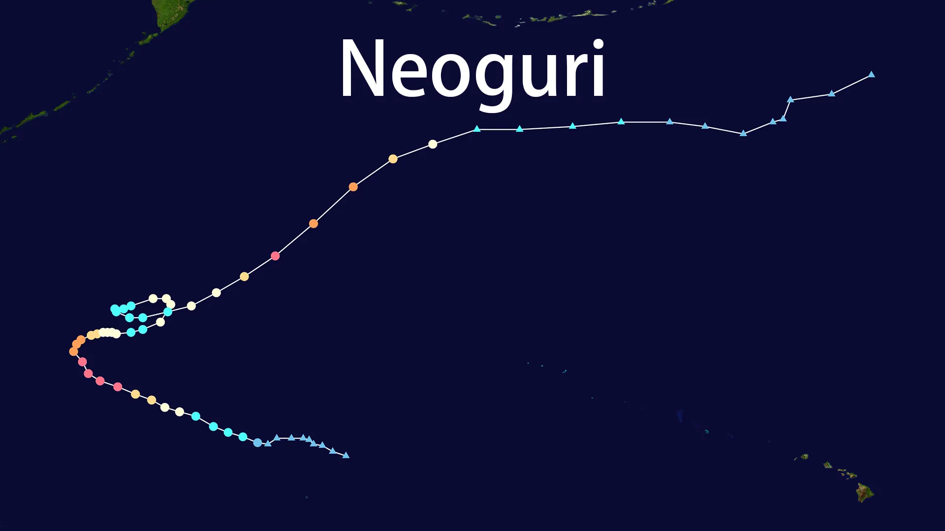
In the vast expanse of the Pacific Ocean, approximately 2,000 miles west of Hawaii, a seemingly innocent area of convection began organizing north of Wake Island in mid-September 2025. What would become Typhoon Neoguri started as a tropical depression on September 17, 2025, initially showing little indication of the meteorological beast it would evolve into. The Japan Meteorological Agency (JMA) officially designated the system as Tropical Storm Neoguri - named after the Korean word for raccoon dog - at 22:20 JST on September 17, marking the beginning of an extraordinary 13-day journey across the Pacific waters.
The early development of Typhoon Neoguri occurred under nearly perfect conditions. Sea surface temperatures ranging between 29-30°C created an ideal energy source, while remarkably low vertical wind shear allowed the system to organize unimpeded. Meteorologists watched with growing interest as the storm began its characteristic west-northwest movement, steered by a subtropical ridge that would guide its initial trajectory. Within 48 hours of formation, the system had already intensified to severe tropical storm status, with the JMA reporting sustained winds of 50 knots by September 19.
Meteorological Evolution: From Tropical Storm to Super Typhoon
The transformation of Typhoon Neoguri from a moderate tropical storm to a violent super typhoon represents one of the most rapid intensification episodes recorded in the 2025 Pacific typhoon season. On September 20, the system reached minimal typhoon status, but the truly explosive development began early on September 21. Satellite imagery captured the formation of a distinct eye feature as the storm underwent what meteorologists call "rapid intensification" - a process where a tropical cyclone's maximum sustained winds increase by at least 30 knots within 24 hours.
Typhoon Neoguri far exceeded this threshold, achieving what the Joint Typhoon Warning Center (JTWC) classified as Category 4 super typhoon status with 1-minute sustained winds reaching 230 km/h (143 mph). The JMA, using their 10-minute averaging standard, reported peak winds of 195 km/h with a central pressure plummeting to 920 hPa. Infrared satellite data revealed an exceptionally warm eye temperature of 19°C at peak intensity - a characteristic often associated with particularly powerful tropical cyclones. The rapid strengthening of Typhoon Neoguri saw winds increase by approximately 55 knots in just 24 hours, a rate that placed it among the most rapidly intensifying storms of the decade.
The Unusual Path of Typhoon Neoguri
The trajectory of Typhoon Neoguri fascinated meteorologists throughout its lifecycle. Initially moving west-northwestward under the influence of a subtropical ridge, the storm began a gradual recurvature that took it on a northward then northeastward track. This path kept the powerful system primarily over open ocean waters throughout its existence, though its enormous wind field extended impacts hundreds of miles from its center.
What made the track of Typhoon Neoguri particularly noteworthy was its ability to maintain significant intensity at unusually high latitudes. While most tropical cyclones weaken substantially upon reaching latitudes north of 30°N, Typhoon Neoguri demonstrated remarkable resilience, briefly re-intensifying to Category 4 equivalent status on September 27 while positioned near 35°N latitude. This high-latitude strength displayed by Typhoon Neoguri represents a growing pattern meteorologists have observed in recent years, potentially linked to broader climate shifts extending the geographical range where intense tropical cyclones can maintain their structure.
Structural Characteristics and Eyewall Replacement
The internal dynamics of Typhoon Neoguri featured several fascinating meteorological phenomena, including multiple eyewall replacement cycles that caused fluctuations in its intensity. During its peak on September 21-22, the storm displayed a well-defined eye approximately 25 nautical miles in diameter, surrounded by a ring of intense convection where the strongest winds and heaviest rainfall occurred.
As is common with intense tropical cyclones, Typhoon Neoguri underwent an eyewall replacement cycle around September 22-23, where an outer eyewall formed and gradually constricted, eventually replacing the original inner eyewall. This process temporarily weakened the storm as it redistributed angular momentum, but ultimately led to an expansion of the wind field. The gale-force wind radius of Typhoon Neoguri extended up to 270 nautical miles from the center at its maximum extent, creating hazardous marine conditions across a vast area of the western Pacific.
Impacts and Marine Hazards
Despite its exceptional intensity, the primarily oceanic path of Typhoon Neoguri limited its direct impacts on populated land areas. Wake Island experienced the outer bands of the developing system around September 18-19, with periods of heavy rainfall and tropical storm-force wind gusts reported. As the storm progressed northward, it generated enormous swells that radiated outward across the Pacific, creating hazardous conditions for maritime interests throughout the region.
The most significant impacts from Typhoon Neoguri were felt across shipping lanes and marine operations. Wave heights within the storm's inner core likely exceeded 12 meters (40 feet) at peak intensity, creating extremely dangerous conditions for any vessels caught in its path. The remote trajectory of Typhoon Neoguri fortunately meant that few shipping interests were directly affected, though maritime warnings were issued extensively as the storm progressed through its lifecycle. The Aleutian Islands experienced elevated surf conditions as swells from the distant storm reached their shores in late September.
The Extratropical Transition of Neoguri
The final chapter in the life of Typhoon Neoguri began around September 28 as the system encountered increasingly cool waters and stronger vertical wind shear north of 40°N latitude. The storm began losing tropical characteristics, undergoing extratropical transition as it interacted with the mid-latitude baroclinic zone. During this process, the energy source shifted from latent heat release to baroclinic processes, and the cloud pattern transformed from the symmetric structure of a tropical cyclone to the comma-shaped cloud signature typical of extratropical systems.
By September 29, the JMA declared that Typhoon Neoguri had completed its transition to an extratropical cyclone, with the system maintaining a central pressure of approximately 970 hPa but with winds spreading over a broader area. The remnants of what was once the powerful Typhoon Neoguri continued northeastward before fully dissipating over the cold waters of the northern Pacific on September 30, having traveled a total distance of over 5,200 kilometers during its 13-day existence.
Meteorological Significance and Climate Context
The development and behavior of Typhoon Neoguri provided valuable insights into several emerging meteorological trends. Its ability to maintain significant intensity at higher latitudes aligns with research suggesting that tropical cyclones are increasingly penetrating into regions previously considered marginal for such systems. The rapid intensification displayed by Typhoon Neoguri also reflects a pattern observed in recent years, potentially linked to warming ocean temperatures and changing atmospheric conditions.
Typhoon Neoguri represented the 19th named storm of the active 2025 Pacific typhoon season and the second system to reach super typhoon status. Its formation during late September placed it in what is typically the climatological peak of the Western Pacific typhoon season, which runs from May through November. The storm coexisted with other systems, most notably Typhoon Ragasa, creating a rare instance of twin super typhoons in the Western Pacific basin - a phenomenon that occurs only a few times per decade.
Preparedness and Warning Systems
The forecasting of Typhoon Neoguri demonstrated significant advances in tropical cyclone prediction, particularly regarding track forecasting. The JMA and JTWC provided consistent and accurate predictions of the storm's recurvature and eventual extratropical transition, allowing maritime interests ample time to adjust routes and operations. The remote path of Typhoon Neoguri meant that extensive coastal preparations were unnecessary, though meteorological agencies maintained vigilant monitoring throughout the storm's lifecycle.
The case of Typhoon Neoguri underscores the importance of maintaining robust tropical cyclone warning systems even for storms that ultimately remain over open water. The potential for last-minute track changes always exists, and the storm's intensity meant that any deviation toward populated areas would have required rapid response. Fortunately, the accurate forecasting of Typhoon Neoguri's path allowed resources to be focused on other systems, particularly Typhoon Ragasa, which posed more immediate threats to land areas in the Philippines and East Asia.
Legacy and Scientific Value
While Typhoon Neoguri will not be remembered for devastating land impacts, its meteorological significance ensures its place in the annals of tropical cyclone history. The storm provided an excellent case study for high-latitude tropical cyclone behavior, rapid intensification processes, and extratropical transition dynamics. The extensive satellite coverage of Typhoon Neoguri, including advanced Himawari satellite imagery that captured its entire 13-day lifecycle, will provide valuable data for researchers studying tropical cyclone structure and evolution for years to come.
The journey of Typhoon Neoguri from a modest tropical disturbance north of Wake Island to a powerful super typhoon and eventually to an extratropical remnant exemplifies the complete lifecycle of tropical cyclones in the Western Pacific. Its story reminds us of the immense power contained within these marine weather systems and the importance of continued scientific study to better understand their behavior in our changing climate.