
The Story of Tropical Storm Awo: A Fleeting Marvel of the 2025 Season
While the annals of meteorology are filled with tales of monstrous cyclones that rewrite coastlines, the story of Tropical Storm Awo proves that significance isn't measured by strength alone. This brief but noteworthy weather event captivated forecasters in August 2025, not for its destructive power, but for its meteorological peculiarity and the valuable lessons it offered. The journey of Tropical Storm Awo serves as a poignant reminder of the delicate balance of forces that govern our atmosphere.
A Rare August Birth: The Formation of Tropical Storm Awo
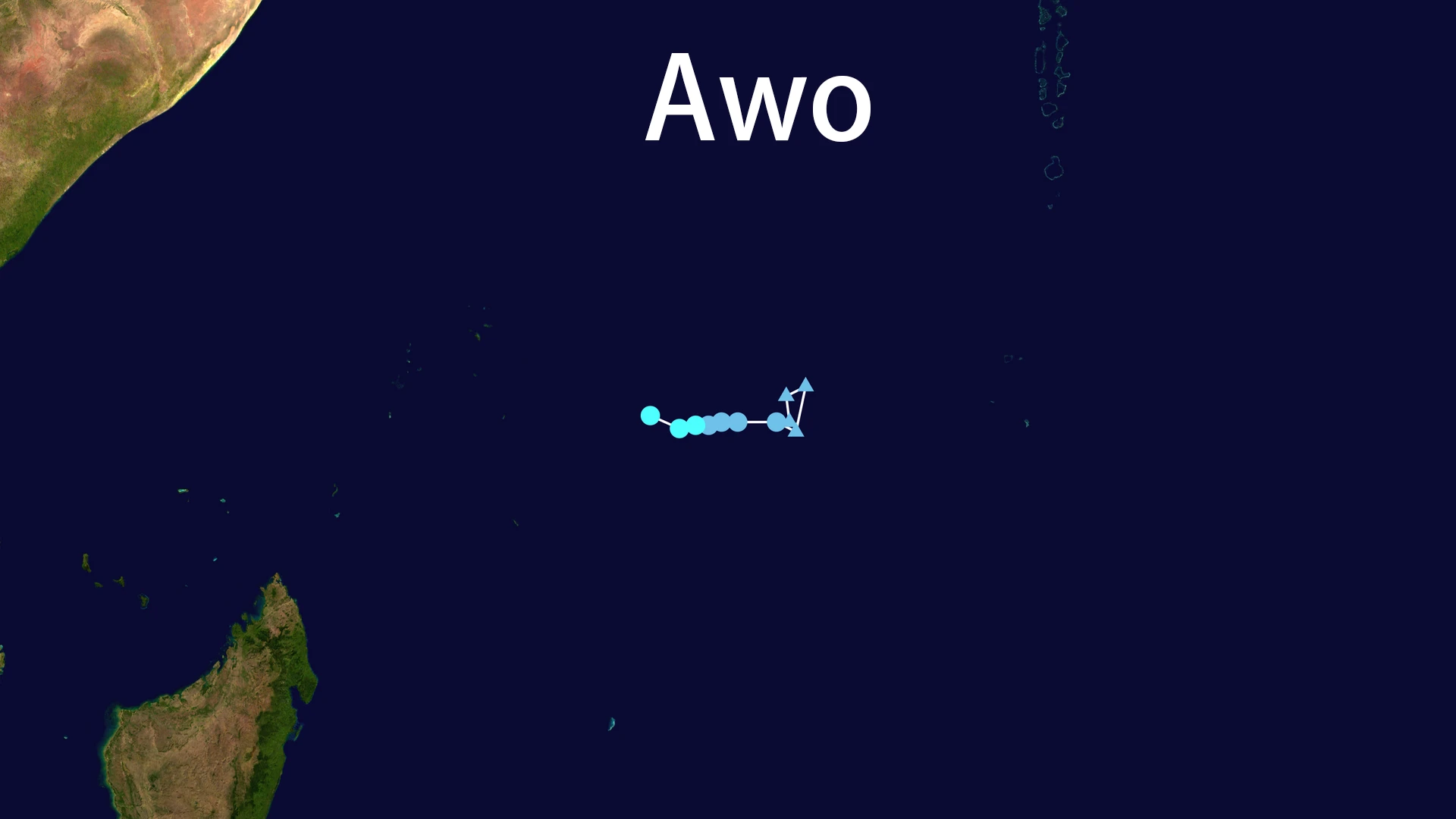
The southwestern Indian Ocean is typically quiet in August, a calm before the peak of the cyclone season. However, the 2025 season defied expectations. On August 7, 2025, a cluster of thunderstorms coalesced into an organized system. The Mauritius Meteorological Services, the regional monitoring authority, designated it as a tropical depression and, shortly after, bestowed upon it the name Tropical Storm Awo.
The formation of Tropical Storm Awo was instantly significant. It marked the first named storm to form in the southwestern Indian Ocean basin in the month of August since Tropical Storm Aline in 1969—a gap of over 55 years. This rarity immediately placed Tropical Storm Awo under the microscope of climatologists and meteorologists, who saw it as a potential signal of shifting patterns in a warming world. Embedded in favorable, albeit marginally warm, sea surfaces, the nascent Tropical Storm Awo began its short life moving northwest, guided by the flow around a subtropical ridge.
A Fleeting Peak: The Brief Intensity of Tropical Storm Awo
Tropical Storm Awo reached its maximum strength almost as soon as it was named. The official Regional Specialized Meteorological Centre (RSMC) in La Réçon determined that Tropical Storm Awo achieved peak sustained winds of 65 km/h (40 mph), with a minimum central pressure of 1000 hPa. This classified it as a "Moderate Tropical Storm," a modest but definitive intensity.
However, this peak was fleeting. The lifecycle of Tropical Storm Awo was a race between organization and disintegration. For a brief period, satellite imagery showed a concentrated area of deep convection near its center, the hallmark of a healthy tropical system. Yet, this organization was tenuous. The story of Tropical Storm Awo is not one of relentless strengthening, but of a constant struggle against hostile atmospheric conditions that would ultimately seal its fate.
The Inevitable Demise: Why Tropical Storm Awo Dissipated So Quickly
The rapid dissipation of Tropical Storm Awo is a classic case study in tropical meteorology. Just a day after its naming on August 8, the storm began to unravel with startling speed. The primary culprits were two well-known storm killers: dry air and wind shear.
As Tropical Storm Awo moved northwest, it ingested a large mass of dry, Saharan air. This dry air infiltrated the storm's core, choking its thunderstorm activity by evaporating rain and disrupting the heat engine that fuels tropical systems. Simultaneously, moderate to strong vertical wind shear, exceeding 20 knots, acted like a relentless pair of hands, tearing the upper-level clouds and convection away from the low-level circulation center. Satellite images vividly depicted this structural collapse, showing the storm's lifeblood—its deep convection—being stripped hundreds of kilometers downwind. By August 8, the circulation of Tropical Storm Awo had become exposed and elongated, leading to its downgrade to a tropical depression and its eventual dissipation over open waters.
Minimal Impact, Maximum Preparedness: The Legacy of Tropical Storm Awo
From a humanitarian perspective, Tropical Storm Awo was a non-event, and in the world of disaster management, that is a success story. The Global Disaster Alert and Coordination System (GDACS) classified its impact as "Green," indicating a low humanitarian risk. No casualties or economic damages were reported.
This positive outcome was not merely luck. The meteorological services of Seychelles had issued timely "Moderate Tropical Storm" warnings for islands like Mahé, Praslin, and La Digue. These alerts, while not signaling a catastrophic event, advised caution, particularly for mariners who faced rough seas. The case of Tropical Storm Awo demonstrates the critical importance of a robust early warning system. Even for storms of low intensity, accurate forecasting and clear communication are essential for public safety and demonstrate effective governance in the face of natural hazards.
Conclusion: The Enduring Significance of Tropical Storm Awo
Though it lived for less than a day as a named storm, Tropical Storm Awo left a lasting impression. It was a meteorological novelty, breaking a half-century-long quiet spell for August in its basin. Its rapid formation and even quicker dissipation provide a textbook example of how environmental factors like dry air and wind shear can dominate a storm's destiny.
The story of Tropical Storm Awo is a humbling narrative. It illustrates that in an era often focused on record-breaking intensity, there is profound value in understanding the entire spectrum of tropical weather—from the weakest disturbances to the most powerful hurricanes. This brief, elegant dance of atmospheric forces over the open ocean in August 2025 remains a compelling chapter in the ongoing story of our planet's climate.