
Tropical Storm Chantal 2025: The Deceptive Deluge
Birth in the Atlantic Crucible
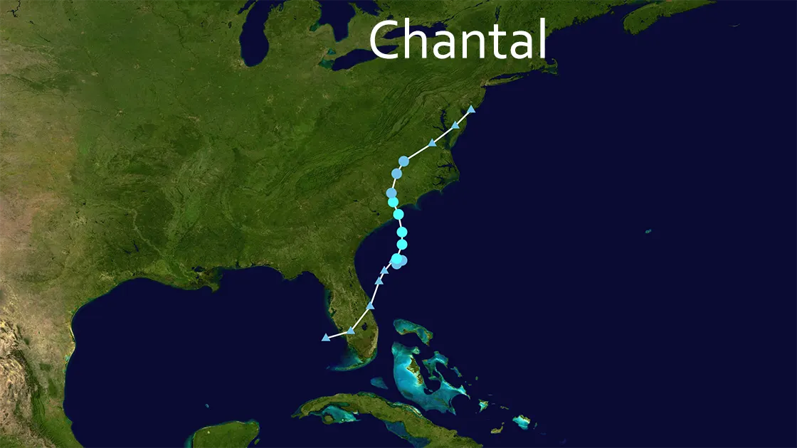
July 4, 2025, 200 miles east of Jacksonville, FL: Beneath Independence Day fireworks, a more ominous spectacle brewed. Satellite imagery captured a swirl consolidating over 80°F waters—Tropical Depression Three took form. Within 24 hours, this disturbance defied July's typical slumber, intensifying into Tropical Storm Chantal on July 5th. The 2025 Atlantic hurricane season's third named storm had arrived weeks ahead of schedule. But Chantal faced immediate hostility: southerly wind shear tore at its structure, leaving it ragged. Then, under cover of darkness, Chantal seized a window. By 2:00 a.m. EDT on July 6, it achieved peak fury—60 mph (96 km/h) winds, pressure plummeting to 1002 millibars. Its crosshairs fixed on the Carolina coast.
Landfall at Litchfield: The Illusion of Control
4:00 a.m. EDT, July 6, 2025 - Litchfield Beach, SC: Chantal slammed ashore with a deceptive roar. Winds screamed at 60 mph at landfall; Springmaid Pier in Myrtle Beach recorded 56 mph gusts. A 1-3 foot storm surge swallowed beaches at high tide. Yet coastal residents breathed tentative relief—damage seemed manageable: some flooded roads, minor erosion. Chantal's true weapon wasn't wind, but water. And it was already marching north-northwest, then northeast, toward unprepared inland targets. By mid-morning, downgraded to a depression, Chantal played dead. It was a lethal ruse.
North Carolina's Watery Ambush
While South Carolina assessed superficial wounds, Chantal unleashed hell 200 miles inland. Central North Carolina became a drowning chamber:
- The Rain Bomb: Cloudbursts dumped 4-6 inches widely—but north of Bynum, a rain gauge choked on 14 inches. Within hours, creeks became torrents, parking lots became lakes.
- Apocalypse in Chapel Hill: Floodwaters burst into apartments before dawn. The Chapel Hill Fire Department launched over 50 water rescues—residents hauled from second-story windows, 60+ families displaced in waist-deep currents.
- Twister Terror: At 4:27 a.m. EDT, as Chantal's outer bands raked Wilmington, an EF-1 tornado tore through Kings Grant. For over a mile, it shredded roofs and snapped century-old oaks.
- The Human Cost: In Chatham County, 83-year-old Sandra Portnoy Hirschman drowned when floodwaters invaded her home—Chantal's sole direct fatality, a life claimed not by wind, but by relentless rising water.
By sunset on July 6th, North Carolina lay crippled: hundreds of roads submerged, tens of thousands without power, landscapes scarred by mudslides and splintered trees. Chantal's remnants, now racing northeast, left a state in shock.
Chasing the Ghost: Northeast on Alert
July 7, 2025: Though Chantal officially dissipated, its ghost moisture marched on. Flood watches bloomed across eastern Maryland, Delaware, and New Jersey. While impacts proved milder (2-4 inches of rain), the psychological shadow lingered. Emergency managers from Richmond to Trenton tracked radar loops, knowing Chantal had demonstrated a terrifying formula: a "weak" tropical storm could weaponize its moisture far beyond landfall.
Response: Heroes in the Muck
The National Hurricane Center (NHC) had issued tropical storm warnings, but Chantal's inland flooding defied simple alerts. The real battle unfolded in real-time:
- Chapel Hill Firefighters: Wading through toxic, chest-high water for 50+ rescues, their headlamps cutting through predawn gloom.
- Power Line Warriors: Climbing poles in driving rain as downed trees draped live wires across neighborhoods.
- NWS Meteorologists: Issuing flash flood warnings with urgent specificity: "SEEK HIGHER GROUND NOW! Floodwaters moving at 15 mph down Hillsborough Street!"
The mantra echoed across airwaves: "Turn Around, Don't Drown." For most, it was heeded. For Sandra Hirschman, it came too late.
2025's Ominous Rhythm
Tropical Storm Chantal wasn't an anomaly—it was a punctuation mark in an alarming sentence. The third named storm of the 2025 Atlantic season, it formed on July 4th—weeks ahead of the historical average for Storm #3 (mid-July). This followed Andrea (June 24) and Barry (June 28), fulfilling NOAA's prediction of 13-19 named storms. Chantal's record-breaking rainfall wasn't random; climate change loaded the dice, supercharging storms with warmer oceans and a thirstier atmosphere. A "mere" tropical storm proved deadlier than many hurricanes. As recovery crews pumped out basements in Raleigh on July 9, 2025, the lesson screamed: in this new era, there are no "minor" storms. Chantal was the ghost of seasons future—a watery, relentless, and deceptive omen.
Tropical Storm Chantal 2025: The Hard Numbers
| Aspect | Impact |
|---|---|
| Formation | July 4, 2025 (Tropical Depression) → Tropical Storm Chantal July 5 |
| Peak Intensity | 60 mph (96 km/h), 1002 mb (July 6, 2 AM EDT) |
| Landfall | July 6, 4 AM EDT - Litchfield Beach, SC (60 mph) |
| Dissipation | July 7, 2025 (Post-Tropical) |
| SC Impact | 4-6 in rain | 1-3 ft surge | 56 mph gusts (Myrtle Bch) |
| NC Catastrophe | 4-14 in rain | 1 Fatality | 50+ Rescues | 60+ Displaced |
| Tornadoes | EF-1 Confirmed (Kings Grant, NC - 1+ mile path) |
| Season Context | 3rd Named Storm (2025 Atlantic) - Formed weeks ahead of schedule |