
Hurricane Flossie 2025: The Record-Breaking Ghost That Haunted Mexico's Coast
The Pacific's Stealth Bomber
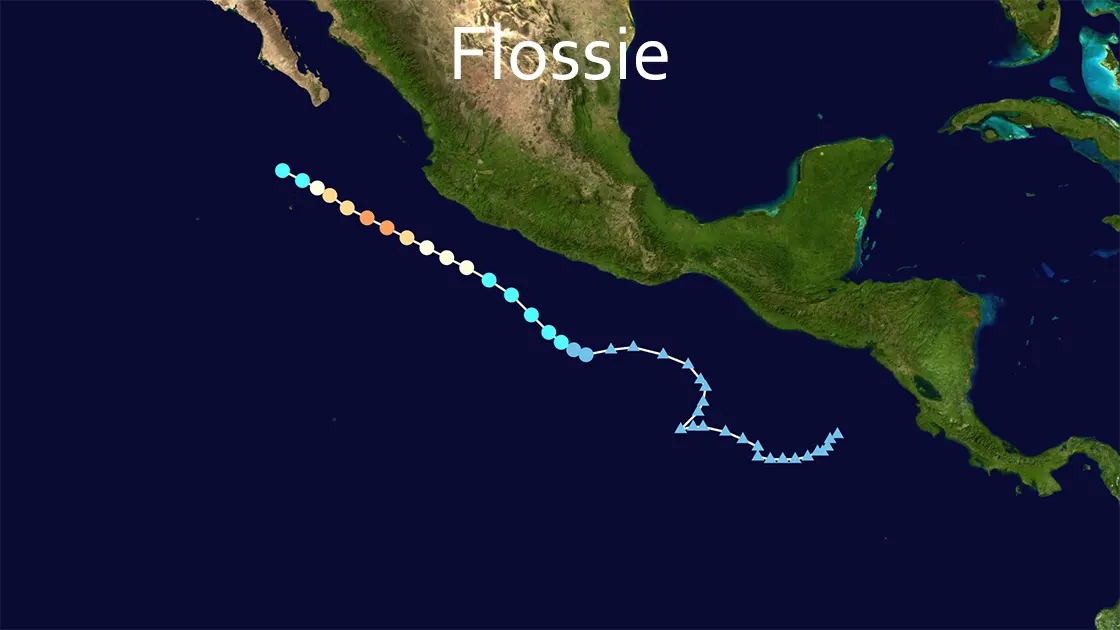
In the twilight of June 29, 2025, a swirl of clouds 400 miles west of Nicaragua pulsed with latent fury. Flossie emerged as Tropical Depression Six-E in waters simmering 1.5°C above normal—a climate-change-charged incubator. Within hours, it became Tropical Storm Flossie, then detonated. By July 1, Flossie's winds screamed to 115 mph (185 km/h)—a Category 3 hurricane with a 962 mbar heart of darkness. This rapid intensification vaulted Flossie into history as the earliest "F" storm ever recorded in the Eastern Pacific, its core churning just 315 miles SSE of Cabo San Lucas. Meteorologists stared at satellite loops showing Flossie's 80 mph wind surge in 36 hours, whispering: "This isn't normal."
The Near-Miss Nightmare
Flossie’s eye never touched land, but its 150-mile-wide reach became a coastal terror. Off Manzanillo, fishing boats vanished beneath 25-foot swells as Flossie’s outer bands lashed Michoacán to Oaxaca with 10-inch rain bombs. In Acapulco—still scarred by 2023’s Hurricane Otis—streets transformed into brown rivers. PBS News captured shopkeepers knee-deep in floodwater, salvaging inventory as Flossie’s torrents crashed through doors. "It felt like Otis’ ghost returned," confessed María Torres, wading through her drowned bakery. The true killer hid in the sea: deadly rip currents tore along the Baja Peninsula, forcing Los Cabos Port to seal its gates on July 1. One fisherman, defying black-flag warnings, vanished into Flossie’s maw—the storm’s lone confirmed fatality.
Dance With Dissipation
By July 2, Flossie began unraveling. Wind shear sliced its structure as it drifted over cooler waters 215 miles south of Cabo San Lucas. NOAA’s Hurricane Hunter aircraft recorded winds plummeting to 75 mph—now just a Category 1. Yet Flossie clung to life, its northwest crawl at 8 mph (13 km/h) prolonging the agony. At 2:00 PM MST on July 3, Flossie was downgraded to a tropical storm at 21.2N 112.4W, exhaling 45 mph gusts 200 miles southwest of Cabo. By dusk, it gasped its last as a post-tropical cyclone with 40 mph winds, dissolving into Pacific memory near Socorro Island. The U.S. Embassy in Mexico lifted alerts, but beachside bars in Zihuatanejo remained shuttered, their owners eyeing the still-choppy sea.
Why Flossie Mattered: The Climate Code Red
Flossie was no footnote. As the sixth named storm, third hurricane, and second major hurricane of 2025’s hyperactive season, it smashed multiple records:
- ✔️ Earliest "F" storm (beating prior records by weeks)
- ✔️ Second major hurricane by July 1—45 days ahead of historical average
- ✔️ Part of NOAA’s predicted 13-19 named storms, signaling a relentless season
Meteorologist Alex DaSilva linked Flossie’s fury to marine heatwaves: "These waters are rocket fuel." Climate models show Eastern Pacific cyclones now intensify 40% faster than in the 1980s—a trend Flossie embodied with terrifying precision.
The Ghost’s Legacy
When Flossie dissipated on July 3, damage seemed minimal: no mass blackouts, no collapsed bridges. But in Guerrero’s hills, landslides buried farms. In Colima, 3-6 inches of rain triggered mudslides that severed rural roads. The economic toll stayed low, but trauma lingered. "We prepared for another Otis," admitted Carlos Méndez, Acapulco’s emergency director, referencing the Mexican Navy’s 6,418 personnel placed on standby. Ultimately, Flossie was a warning shot—a demonstration of how climate-amped storms could menace coasts without direct hits. As Cabo’s beaches reopened on July 4, scientists issued a grim footnote: Flossie-like near-misses would become routine in overheated oceans. The ghost left no ruins, but its message echoed: Next time, we might not miss.