Courtney

Dissipated

Active from March 24, 2025 at 12:00 PM to April 3, 2025 at 06:00 AM

Track map of Courtney

Peak Category

Dissipated

Minimum Pressure

hPa

Maximum Wind Speed

238 km/h

Region

South Indian Ocean

Key Events

Formation

March 24, 2025 at 12:00 PM

-16.6°N, 111.0°E

Dissipation

April 3, 2025 at 06:00 AM

-25.0°N, 80.5°E

Storm Timeline

Courtney formed as tropical_cyclone at -16.6°N, 111.0°E with winds of 61 km/h

March 24, 2025 at 06:00 PM: maintain at -16.6°N, 110.5°E

March 25, 2025 at 12:00 AM: maintain at -16.7°N, 110.0°E

Courtney intensified to tropical_cyclone at -16.8°N, 109.1°E with winds of 72 km/h

March 25, 2025 at 12:00 PM: maintain at -17.0°N, 108.2°E

Courtney intensified to tropical_cyclone at -17.3°N, 106.8°E with winds of 79 km/h

Courtney intensified to tropical_cyclone at -17.8°N, 105.3°E with winds of 101 km/h

Courtney intensified to tropical_cyclone at -18.0°N, 104.1°E with winds of 108 km/h

March 26, 2025 at 12:00 PM: maintain at -17.7°N, 103.1°E

Courtney intensified to Category 1 at -17.4°N, 102.2°E with winds of 130 km/h

March 27, 2025 at 12:00 AM: maintain at -17.0°N, 101.1°E

March 27, 2025 at 06:00 AM: maintain at -16.8°N, 100.0°E

March 27, 2025 at 12:00 PM: maintain at -16.8°N, 99.1°E

Courtney intensified to Category 2 at -16.8°N, 98.2°E with winds of 155 km/h

March 28, 2025 at 12:00 AM: maintain at -16.8°N, 97.3°E

March 28, 2025 at 06:00 AM: maintain at -16.8°N, 95.5°E

Courtney intensified to Category 3 at -17.2°N, 94.6°E with winds of 202 km/h

Courtney intensified to Category 4 at -17.4°N, 93.0°E with winds of 212 km/h

March 29, 2025 at 12:00 AM: maintain at -17.7°N, 91.9°E

Courtney intensified to Category 4 at -18.0°N, 91.0°E with winds of 220 km/h

Courtney reached peak intensity as Category 4 at -18.7°N, 90.1°E with winds of 238 km/h

Courtney weakened to Category 4 at -19.5°N, 89.3°E with winds of 230 km/h

Courtney weakened to Category 4 at -20.2°N, 88.9°E with winds of 212 km/h

Courtney weakened to Category 3 at -21.1°N, 88.3°E with winds of 184 km/h

Courtney weakened to Category 2 at -22.0°N, 88.0°E with winds of 155 km/h

Courtney weakened to Category 1 at -22.7°N, 87.9°E with winds of 130 km/h

Courtney weakened to Category 1 at -23.1°N, 88.2°E with winds of 108 km/h

Courtney intensified to Category 1 at -24.0°N, 88.5°E with winds of 119 km/h

Courtney weakened to Category 1 at -24.7°N, 88.9°E with winds of 108 km/h

Courtney weakened to tropical_cyclone at -24.8°N, 88.8°E with winds of 101 km/h

Courtney weakened to tropical_cyclone at -24.9°N, 88.8°E with winds of 90 km/h

Courtney weakened to tropical_cyclone at -25.0°N, 88.4°E with winds of 83 km/h

Courtney weakened to tropical_cyclone at -24.9°N, 88.5°E with winds of 72 km/h

Courtney weakened to tropical_cyclone at -24.8°N, 88.5°E with winds of 61 km/h

April 2, 2025 at 12:00 AM: maintain at -25.2°N, 87.8°E

April 2, 2025 at 06:00 AM: maintain at -25.2°N, 86.5°E

April 2, 2025 at 12:00 PM: maintain at -25.2°N, 85.4°E

April 2, 2025 at 06:00 PM: maintain at -24.7°N, 84.3°E

Courtney dissipated at -25.0°N, 80.5°E

Tropical Cyclone Courtney (27U/27S) - Post-Dissipation Analysis

Cyclone Courtney Development Timeline

  • Naming Date: 26 March 2025 by Australian Bureau of Meteorology
  • Peak Intensity: 29 March 2025 12:00 UTC - Category 4 Equivalent (JTWC: 130kt/240km/h, WMO/RSMC: 204km/h)
  • Dissipation: 03 April 2025 06:00 UTC at 25.0°S 80.5°E

Intensity Progression (JTWC Scale)

Maximum Sustained Winds

Date (UTC) Intensity (kt) Equivalent Category
24 March 12:00 35 Tropical Storm
28 March 18:00 115 Category 4
29 March 12:00 130 (Peak) Category 4
03 April 06:00 30 Dissipated

Pressure Observations

  • Minimum Recorded Pressure: 993 mb (01 April 06:00 UTC)
  • Pressure at Dissipation: 1002 mb

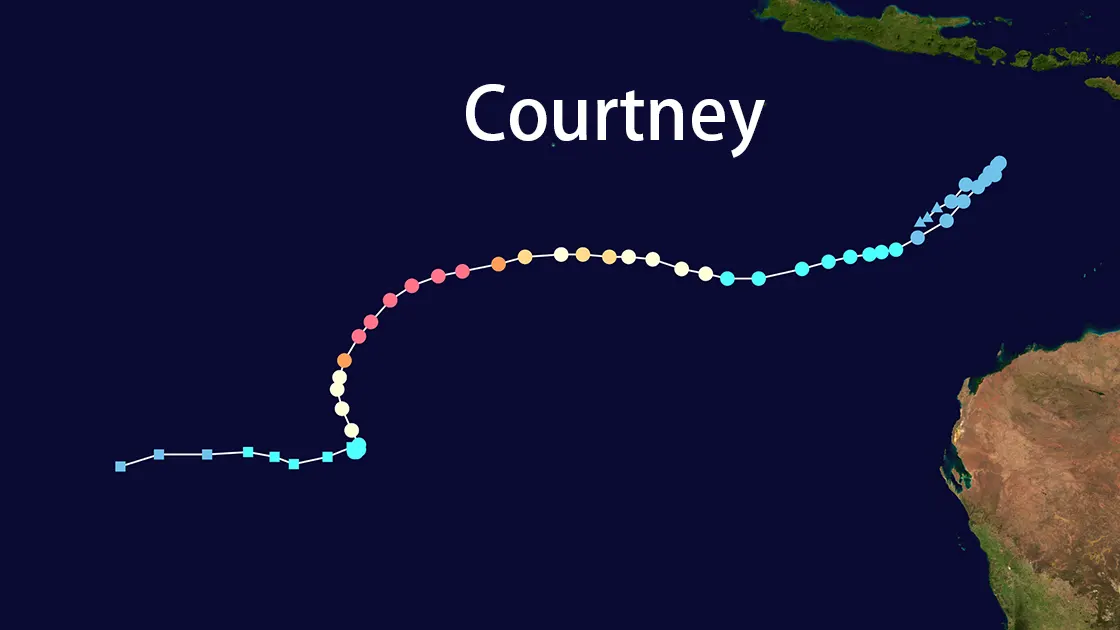
Courtney's Track Characteristics

Movement Patterns
  • Average Speed: 3-5 kt (5.5-9.2 km/h)
  • Total Track Length: 2,850 km (1,770 mi)
  • Notable Direction Shifts:
    • 28 March: Sharp southwest turn at 17.2°S 94.6°E
    • 01 April: Westward acceleration near 25.8°S 88.7°E
Key Positions
Date (UTC) Latitude Longitude Phase
Formation (24 Mar) 16.6°S 111.0°E Initial development
Peak Intensity 18.7°S 90.1°E Eyewall replacement
Final Position 25.0°S 80.5°E Dissipation

Structural Evolution of Courtney

Eyewall Dynamics
  • First Eyewall Formation: 28 March 12:00 UTC (-17.3°S 94.6°E)
  • Eyewall Replacement Cycle: Initiated 29 March 00:00 UTC
  • Convective Collapse: 01 April 06:00 UTC observed through ASCAT imagery
Rainband Configuration
  • Maximum Outflow: 1,200 km diameter (29 March)
  • Dry Air Intrusion: Notable entrainment from NW quadrant after 30 March

Environmental Interactions

Sea Surface Temperatures

  • Formation Zone: 29-30°C
  • Dissipation Zone: 24-25°C

Vertical Wind Shear

Phase Shear Magnitude Direction
Intensification 10-15 kt Easterly
Weakening 50+ kt Northwesterly

Warning Timeline (JTWC)

Advisory Date (UTC) Position Max Winds Significant Wave Height
NR 017 30 Mar 18:00 22.5°S 87.9°E 70 kt 25 ft
NR 020 01 Apr 09:00 25.1°S 88.3°E 45 kt 20 ft

Post-Dissipation Analysis

Courtney's Meteorological Significance
  • Rapid Intensification Rate: 55 kt/24h (28-29 March)
  • Unusual Track Persistence: Maintained westward motion below 25°S
  • Subtropical Transition: Completed 01 April 12:00 UTC
Operational Challenges
  • Forecast Discrepancies:
    • ECMWF underestimated southward component
    • GFS overestimated interaction with mid-latitude trough
  • Observation Gaps: Limited recon data due to remote location

Courtney Track Map
Final observed position of Courtney at 25.0°S 80.5°E with residual swirl pattern visible on Himawari-9 imagery

Legacy in Cyclone Research
  • Case study for subtropical transition mechanisms
  • Validated new ASCAT-based intensity estimation techniques
  • Contributed to WMO Task Force on Remote Sensing Applications