
Tropical Cyclone Dikeledi: A Devastating Force Across Southern Africa
Introduction
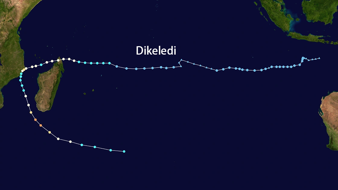
Tropical Cyclone Dikeledi, a powerful weather system that emerged in January 2025, left a trail of destruction across Madagascar, Mozambique, and neighboring regions. With peak sustained winds reaching 232 km/h, the cyclone triggered catastrophic flooding, infrastructure damage, and widespread displacement. This article synthesizes key impacts, emergency responses, and forecasts to raise awareness of its humanitarian and environmental consequences.
Path and Intensity
Formation and Initial Impact
Dikeledi first struck northern Madagascar on 11 January, causing three fatalities, displacing 352 people, and damaging over 1,000 houses. Initial assessments indicated 7,028 affected individuals in Analanjirofo, Diana, and Sava regions, with 209 homes destroyed and 250 classrooms damaged, disrupting education for 8,000 children. By 13 January, the cyclone re-entered the Mozambique Channel, intensifying to 158 km/h before making landfall near Nacala, Mozambique, where it destroyed 15,000 homes and displaced 283,334 people.
Secondary Landfall and Strengthening
On 15 January, Dikeledi rapidly intensified into an intense tropical cyclone while moving parallel to Madagascar's southwest coast. Meteorological agencies warned of heavy rainfall (200 mm/24h), storm surges, and hazardous sea conditions in Toliara Province15. By 16 January, it reached peak winds of 232 km/h over the Mozambique Channel, threatening coastal communities with extreme weather.
Humanitarian Impact
Madagascar
Northern Regions: Over 5,800 people were affected, with 1,185 houses flooded and 69 schools damaged. By 15 January, displaced populations returned home despite ongoing risks.
Southwest Coast: Toliara Province faced torrential rains and destructive winds, prompting port closures and bans on maritime activities.
Mozambique
Nampula Province: The hardest-hit area saw 283,334 affected individuals, including 45,333 people with disabilities. Damage included 80,865 houses, 221 schools, and 48 health facilities.
Infrastructure Collapse: Roads, power lines, and communication networks were severed, isolating districts like Mongicual and Angoche.
Regional Threats
Mayotte and Comoros reported 20,000 evacuations, while Mozambique's Zambezia Province faced flooding risks due to Dikeledi's residual rains.
Emergency Response
Madagascar's Efforts
The government deployed pre-positioned supplies, distributing 350 metric tons of food and WASH kits to 40 families in Ambilobe District.
Schools reopened partially by 13 January, with child-friendly spaces established in affected areas.
Mozambique's Crisis Management
The National Institute for Disaster Management (INGD) activated anticipatory protocols, prioritizing shelter, food, and healthcare. Humanitarian partners like IOM and OCHA conducted rapid assessments to address urgent needs.
Electricity restoration efforts began in Nacala, though 113,000 households remained without power.
International Coordination
The GDACS issued Orange alerts for Madagascar and Mozambique, highlighting risks to 6 million people.
Disease surveillance intensified amid cholera risks in Angoche and Mogincual districts.
Forecast and Long-Term Risks
Continued Threats
Dikeledi's remnants are expected to weaken over cooler subtropical waters by late January, but its legacy includes:
Agricultural Losses: 4,092 hectares of farmland damaged, threatening food security.
Climate Vulnerability: Mozambique's back-to-back cyclones (Chido and Dikeledi) underscore the region's exposure to climate-driven disasters.
Future Preparedness
Meteorologists warn of an active 2025 cyclone season until April, urging investments in early warning systems and resilient infrastructure.
Conclusion
Tropical Cyclone Dikeledi exemplifies the escalating humanitarian crises linked to climate change. Its dual impact on Madagascar and Mozambique—destroying homes, displacing thousands, and crippling critical infrastructure—demands sustained international aid and adaptive strategies. As Dikeledi dissipates, its lessons must drive global efforts to mitigate future disasters.
Key Statistics
Peak Winds: 232 km/h
Affected Population: Over 389,334 in Mozambique
Damaged Houses: 80,865 in Mozambique; 1,092 in Madagascar1
Critical Needs: Shelter, WASH, healthcare, and food security.