
Cyclone Sean: How a Record-Breaking Storm Brought Both Destruction and Relief to Western Australia
Introduction
Tropical Cyclone Sean, which formed on 17 January 2025, quickly intensified into a severe tropical cyclone, bringing record-breaking rainfall and strong winds to Western Australia. This article explores the formation, intensification, and impacts of Cyclone Sean, highlighting its significance in the 2024/25 Australian cyclone season and its dual role as both a destructive force and a bringer of relief to drought-stricken regions.
Formation and Rapid Intensification
Initial Development
Tropical Low 11U formed west of the Kimberley coast on 17 January 2025. Its initial development was slow due to the presence of another tropical low, 10U, to the west. However, as 10U dissipated, 11U began to strengthen, fueled by near-record warm sea surface temperatures—a key factor in its rapid intensification. According to the Australian Bureau of Meteorology (BoM), sea surface temperatures in the region were 1.5°C to 2°C above average, creating ideal conditions for cyclone development.
Naming and Rapid Intensification
By 19 January, 11U had developed into Tropical Cyclone Sean, named by the BoM. Sean rapidly intensified, reaching Category 3 status on the Australian scale by 20 January. The cyclone developed a well-defined eye, and by 16:00 AWST, it had reached 10-minute sustained winds of 165 km/h, classifying it as a Category 4 cyclone on the Australian scale. On the Saffir-Simpson Hurricane Wind Scale, Sean's 1-minute sustained winds peaked at 125 mph (201 km/h), making it a Category 3 storm.
Path and Peak Strength
Movement and Trajectory
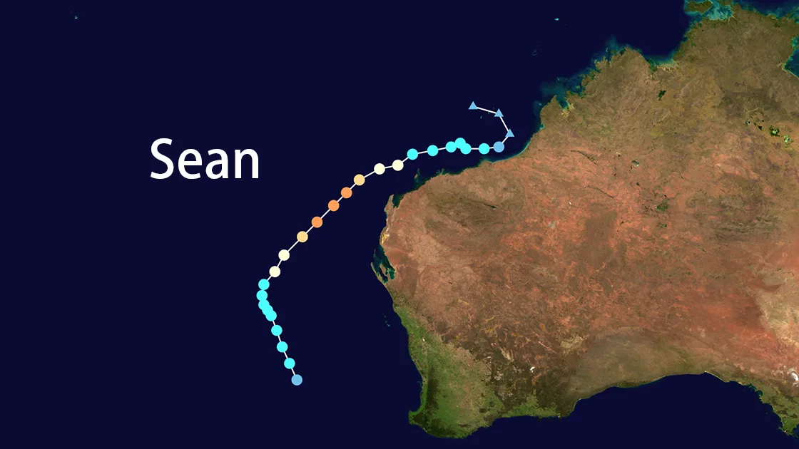
Cyclone Sean initially moved westward, parallel to the Pilbara coast, before turning southwest. It reached its peak intensity on 20 January, with maximum sustained winds of 175 km/h (95 knots), located approximately 350 km west of Exmouth. The cyclone's path kept it largely offshore, sparing the mainland from the worst of its winds but bringing heavy rainfall to coastal regions.
Record-Breaking Rainfall
The most significant impact of Cyclone Sean was the torrential rainfall. Karratha, a town in the Pilbara region, recorded 274.4 mm of rain in 24 hours—breaking its previous record for the wettest day in any month. This rainfall also surpassed the town's entire monthly January average of 263.4 mm. According to the BoM, the intense rainband that moved across Karratha on 19 January was a key contributor to the record-breaking totals.
Impacts and Aftermath
Wind and Flood Damage
Cyclone Sean brought gale-force winds and intense rainfall to the Pilbara and Gascoyne regions. Wind gusts reached up to 120 km/h, causing power outages, road closures, and flooding. The combination of a shelf wave and storm surge generated tides 0.50 to 1.15 meters above normal, with the highest surge recorded at Exmouth due to the funneling effect of the gulf.
Economic and Social Impact
Despite the damage, the mood in Pilbara was described as "largely celebratory" by ABC News. The region had been suffering from prolonged drought, with December 2024 rainfall in the lowest 10% of records since 1900. For cattle farmers, the cyclone brought much-needed relief, replenishing pastures and offering hope for a profitable year. However, the flooding also caused significant damage to infrastructure, with hundreds of homes and roads inundated.
Monitoring and Response
Satellite Imagery and Data
The Moderate Resolution Imaging Spectroradiometer (MODIS) on NASA’s Terra satellite captured true-color images of Cyclone Sean near its peak strength. Additionally, the Copernicus Sentinel-3 satellites provided crucial data for monitoring the cyclone's path and impacts. These open-data resources play a vital role in understanding extreme weather events and supporting disaster preparedness efforts.
Emergency Response
Authorities issued warnings and worked to rescue those affected by flooding. Emergency teams addressed power outages and road damage, ensuring the safety and recovery of impacted communities. The BoM's timely updates and accurate forecasts were instrumental in minimizing the cyclone's human toll.
Climate Context and Future Implications
Cyclone Sean's rapid intensification and record-breaking rainfall raise questions about the role of climate change in extreme weather events. According to the Intergovernmental Panel on Climate Change (IPCC), warmer sea surface temperatures and higher atmospheric moisture levels are likely to increase the intensity of tropical cyclones in the future. While it is difficult to attribute any single event to climate change, Sean's development in near-record warm waters aligns with these broader trends.
Conclusion
Tropical Cyclone Sean was a significant meteorological event in the 2024/25 Australian cyclone season. Its record-breaking rainfall and strong winds brought both destruction and relief to Western Australia, highlighting the complex impacts of tropical cyclones on affected regions. As climate change continues to influence weather patterns, understanding and preparing for such events will be crucial for communities in cyclone-prone areas.
References
- Australian Bureau of Meteorology (BoM) - Cyclone Sean Report, 2025.
- NASA Earth Observatory - MODIS Image of Cyclone Sean.
- Copernicus Sentinel-3 Satellite Data.
- ABC News - Coverage of Cyclone Sean's Impact.
- Intergovernmental Panel on Climate Change (IPCC) - Climate Change and Extreme Weather Events.