
Tropical Storm Dalila 2025: The Pacific's Soaking Shadow
Birth in the Warming Crucible
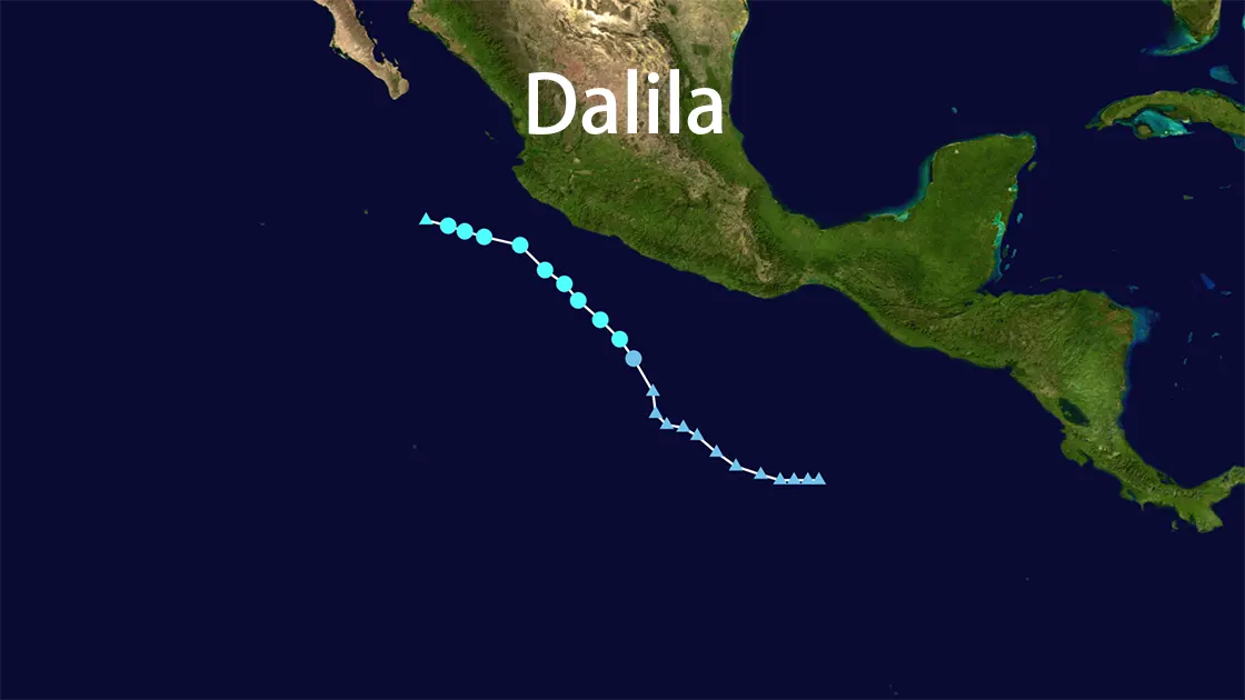
June 12, 2025, 11.3°N 100.2°W - Eastern Pacific: Beneath a searing tropical sun, a cluster of thunderstorms began coiling over ocean waters shimmering at 29°C (84°F). At 3:00 PM CST, the National Hurricane Center (NHC) identified a closed circulation—Potential Tropical Cyclone FOUR-E was born, 450 miles southeast of Zihuatanejo, Mexico. With maximum sustained winds of 35 mph (55 km/h) and a central pressure of 1006 mb, it crawled west-northwest at 7 mph, struggling to organize. Yet the warm ocean proved a potent incubator. Within hours, the system convulsed, shedding its "potential" status. By nightfall, it had a name: Tropical Storm Dalila—the fourth named storm of the hyperactive 2025 Eastern Pacific hurricane season. The NHC’s forecast glowed with a 90% chance of intensification:cite[5]:cite[6].
Race Against the Shear
June 14, 9:00 AM CST - 16.5°N 104.8°W: Dalila defied expectations. Fueled by the heat reservoir of the Pacific, she surged to peak intensity: 60 mph (95 km/h) winds, pressure plummeting to 996 mb. Now 175 miles south of Manzanillo, her tropical-storm-force winds stretched 230 miles outward, lashing the ocean into a fury of whitecaps. Satellite imagery revealed a paradox: deep convection flared near the center, but northeasterly wind shear—an invisible scalpel—began slicing at her structure. The ridge steering her northwest at 12 mph now pushed Dalila toward cooler waters and her own demise. Her dance with destruction had begun:cite[5]:cite[6].
Mexico’s Drenched Coastline
Though Dalila’s core remained offshore, her rain bands became scythes. From June 13-15, they unloaded:
- Acapulco, Guerrero: 9 inches (228 mm) of rain swallowed streets within hours. Mudslides oozed down deforested hillsides. In a visceral moment captured by locals, a giant ceiba tree, its roots liquified by saturation, crashed onto a home in the Colonia Progreso district—a symbol of nature’s brute force:cite[4]:cite[6].
- Michoacán & Colima: Rivers burst banks under 6-9 inch (150-228 mm) deluges, isolating villages. Highway 200 transformed into a debris-choked canal, stranding trucks waist-deep:cite[5].
- The Coastal Curse: Life-threatening surf and rip currents churned along 300 miles of coastline. In Zihuatanejo, fishermen watched waves devour beachfront palapas—structures that survived Hurricane Barbara weeks earlier now splintered by Dalila’s swell:cite[6].
No deaths were reported, but the flooding and landslides exposed fragile infrastructure. Acapulco, still scarred by 2023’s Hurricane Otis, faced yet another test of resilience:cite[9].
The Shearing Blow
June 15, 8:00 PM MST - 18.6°N 109.2°W: The Pacific turned traitor. Cooler waters (below 26°C) starved Dalila, while relentless wind shear tore her convection apart. Satellite loops showed a ghostly swirl—barely recognizable as the storm that threatened Mexico days prior. At 320 miles west of Manzanillo, Dalila was declared a post-tropical cyclone: winds 35 mph, pressure 1004 mb, drifting west-northwest at 9 mph. The NHC issued its final advisory. By June 18, her remnants dissolved into the vast blue, leaving only churned water and rain-soaked memories:cite[5]:cite[6].
The Bigger Picture: A Season on Steroids
Tropical Storm Dalila wasn’t an anomaly—she was an exclamation point. As the fourth named storm before mid-June, her emergence alongside Hurricane Barbara and Tropical Storm Cosme signaled an unprecedented start to the 2025 Pacific hurricane season:cite[5]:cite[6].
Why So Early, So Fierce?
- Ocean Heat: Sea surface temperatures (SSTs) reached 2-3°C above normal, turbocharging storm development:cite[6]:cite[9].
- Climate Signal: NOAA’s forecast of 13-19 named storms materialized violently, with Dalila exemplifying how "weak" systems can weaponize moisture:cite[5]:cite[10].
- The Acapulco Syndrome: Cities like Acapulco, wedged between mountains and ocean, face compounding disasters—Dalila’s floods followed Barbara’s surge, revealing a terrifying "disaster debt":cite[4]:cite[9].
Dalila’s legacy? A grim rehearsal for a warming world. Her offshore path spared Mexico catastrophe, but her drenching rains foreshadowed a season where water, not wind, would be the deadliest threat.
Tropical Storm Dalila 2025: Storm Dossier
| Metric | Impact |
|---|---|
| Formation | June 12, 2025 (11.3°N 100.2°W) - Potential TC FOUR-E → Dalila |
| Peak Intensity | 60 mph winds |
| Dissipation | June 15, 2025 (Post-Tropical) → Dissolved by June 18 |
| Key Impact Zone | SW Mexico: Guerrero, Michoacán, Colima, Nayarit, Jalisco |
| Rainfall | 3-9 inches (Coastal Guerrero/Michoacán); 1-9 inches (Inland) |
| Coastal Hazard | Life-threatening surf/rip currents (Guerrero to Colima) |
| Seasonal Context | 4th Named Storm of record-early 2025 EPAC season (Avg. 1st by June 10) |