

Typhoon Wutip: The Latecomer's Deadly Waltz Across the South China Sea
The Unseasonal Storm Awakens
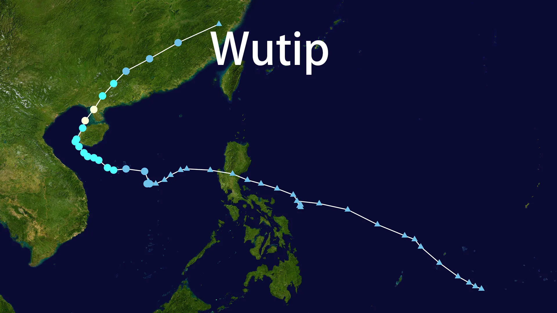
On June 10, 2025, atmospheric pressure plunged near China's Paracel Islands as Tropical Depression 01W stirred in the South China Sea. Meteorologists noted its "bald head" structure—a signature of slow-moving, monsoon-fed storms. When it earned the name Wutip (meaning "butterfly" in Macanese) at 08:00 on June 11, it had already defied expectations. As the latest first typhoon since records began—arriving over two months behind schedule—it drifted northwest at a lethargic 10 km/h. Little did coastal communities know this delay masked devastating intensity.
Coastal Hug: The Dance of Destruction
June 12, Sanya Bay
Palm trees snapped like twigs as winds shrieked at 30.4 m/s. Wutip performed a perilous coastal hug, skirting 95 km south of Hainan Island while dumping apocalyptic rain. In Hue, Vietnam, 800 mm of rain fell in 24 hours—a year’s worth in three days. By midnight on June 13, Wutip slammed into Dongfang City with 980 hPa pressure. Concert screens flashed cancellations as emergency alerts pierced the darkness: "Evacuate NOW—Category 1 direct hit imminent!"
Meanwhile, 700 km north
A supercell spawned twin waterspouts near the Humen Bridge. At 14:36 on June 14, a vortex churned the Pearl River estuary, swallowing fishing boats whole. As Wutip made landfall again near Zhanjiang, Vietnam’s Quang Tri province drowned under 600 mm downpour. Fisherman Tran Van Hai watched his shrimp ponds vanish in brown torrents: "The sea came for everything."
The Human Toll
| Impact Zone | Lives Lost | Economic Devastation |
|---|---|---|
| Vietnam | 6 dead, 1 missing | 58,700 ha crops flooded • 47 homes destroyed |
| China | 3 killed in landslides | 480,000 households blacked out • 8 ships sunk |
| Shared Tragedy | Coastal villages erased | $300M+ estimated damages |
In Guangxi’s Luchuan County, a mudslide buried three generations of the Liang family at 21:00 on June 14. Rescuers clawed through sludge until dawn, retrieving only still bodies. "It sounded like mountains collapsing," neighbor Wu Jing whispered, her own home cracked in half.
Defense Against the Swirl
June 11: The Blue Alert
China’s State Flood Control Bureau activated Level IV response as Vietnam ordered 30,539 fishing boats to port. Helicopters plucked 12 crewmen from a sinking Panamanian rig near Hainan—a rescue nearly foiled by 12-meter waves.
Precision Evacuations
Guangdong executed "Operation Bed Lift," moving 95,794 people from low-lying areas—including 103 bedridden seniors. "We carried them on stretchers through waist-deep water," said Zhanjiang volunteer Chen Bo. When Wutip’s eye passed over Leizhou Peninsula, 70 power repair trucks raced toward crippled grids.
Aftermath: When the Winds Still
By June 15, central emergency funds flowed as survivors tallied losses. Nguyen Thi Lanh stood knee-deep in her ruined rice field near Da Nang: "The butterflies have returned, but our harvest hasn’t." On Hainan’s docks, fishermen mended nets beside the carcasses of eight vessels—their hulls splintered like matchwood.
Wutip’s final act played out in Jiangxi province, where it dissipated after seven days. Its legacy: 13 lives, vanished coastlines, and a haunting question—why did 2025’s first typhoon arrive late yet strike so viciously? Meteorologists point to warming seas. For those who endured its dance, the answer lies in the mud-caked photos of loved ones, and rice paddies shimmering with saltwater.