
Hurricane Gabrielle: The Atlantic's Unexpected Fury Unleashed
In the annals of Atlantic hurricane history, few storms have demonstrated such a dramatic transformation from obscurity to dominance as Hurricane Gabrielle. This formidable system emerged in September 2025, rewriting expectations about late-season cyclone behavior while showcasing nature's capacity for sudden, violent intensification. The story of Hurricane Gabrielle serves as a compelling case study in meteorological unpredictability, tracing a path that began in the remote Atlantic and ultimately captured international attention as it threatened multiple land masses.
The Birth of a Ocean Giant
The origins of Hurricane Gabrielle can be traced to a seemingly unremarkable tropical wave that exited the African coast on September 11, 2025. For days, this system struggled against unfavorable conditions, battling dry air and wind shear that prevented organization. Yet by September 17, approximately midway between Cabo Verde and the Windward Islands, the system consolidated into Tropical Depression Seven. Within hours, it achieved tropical storm status, earning the name Gabrielle. What made Hurricane Gabrielle particularly remarkable was its persistence against initial obstacles, gradually organizing its convective structure while moving west-northwest under the influence of a subtropical ridge.
The transformation of Hurricane Gabrielle from a modest tropical storm to a major hurricane occurred with startling speed. Between September 21-22, the storm underwent rapid intensification, fueled by unusually warm sea surface temperatures of 28-29°C and diminishing wind shear. Hurricane Gabrielle jumped from Category 1 to Category 4 status in less than 24 hours, peaking with maximum sustained winds of 140 mph (220 km/h) and a central pressure of 948 mbar. This placed Hurricane Gabrielle among the most intense storms of the 2025 season, demonstrating how quickly favorable conditions can transform a tropical system.
A Path Through Open Waters
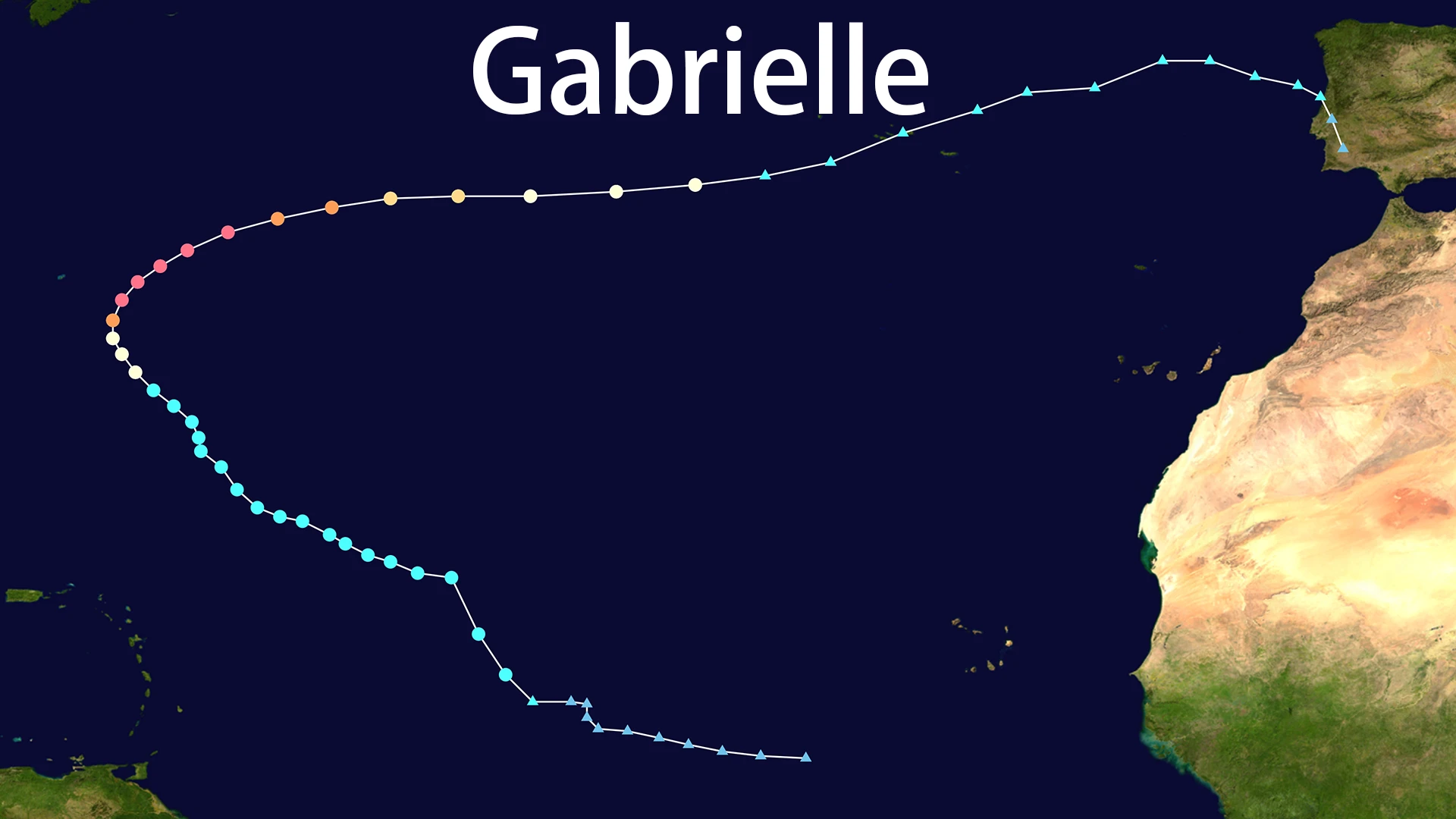
The trajectory of Hurricane Gabrielle proved both predictable in its general direction yet unusual in its ultimate reach. Initially following a classic west-northwest track, the storm turned northward on September 21 as it rounded the periphery of the subtropical high-pressure system. This curve brought Hurricane Gabrielle approximately 180 miles east-southeast of Bermuda at its peak intensity, close enough to generate significant swell and coastal concerns but far enough to avoid catastrophic impacts. The movement of Hurricane Gabrielle then accelerated east-northeastward, setting its sights on the Azores archipelago and potentially Europe.
What made the path of Hurricane Gabrielle meteorologically significant was its transatlantic journey. After passing Bermuda, the storm maintained hurricane strength while crossing increasingly cooler waters, eventually transitioning to a post-tropical cyclone on September 25 as it approached the Azores. The remnants of Hurricane Gabrielle continued toward Portugal, marking one of the rare instances where a tropical system maintained organized structure far into the eastern Atlantic. This behavior echoed historical precedents like Hurricane Vince (2005), reminding forecasters that tropical systems can occasionally influence European weather patterns.
Impacts Across the Atlantic Basin
While Hurricane Gabrielle remained primarily over open ocean for much of its existence, its effects were felt across multiple regions. Bermuda experienced the closest approach of the powerful core of Hurricane Gabrielle, with the island implementing precautionary measures including small craft warnings and beach closures. Though the storm's center remained offshore, Bermuda faced dangerous surf conditions and elevated rip current risks that typify such close encounters with major hurricanes.
The most significant terrestrial impacts from Hurricane Gabrielle occurred in the Azores, where the system arrived as a weakening hurricane on September 26. The Portuguese archipelago activated its emergency response system, with the Institute of the Sea and Atmosphere (IPMA) issuing red alerts for several islands including Flores, Corvo, Terceira, and Faial. Hurricane Gabrielle delivered wind gusts up to 115 mph on Terceira Island, causing fallen trees, structural damage, and power outages. Approximately 16 people required displacement due to storm effects, with emergency services responding to 59 incidents across the islands. The passage of Hurricane Gabrielle led to school and government building closures, port shutdowns, and flight cancellations as the region braced for the unusual tropical impact.
Beyond these direct effects, Hurricane Gabrielle generated Atlantic-wide consequences. Swell radiating from the large circulation of Hurricane Gabrielle reached the U.S. East Coast north of North Carolina, creating dangerous beach conditions days after the storm's peak. The system's moisture also interacted with European weather patterns, potentially influencing rainfall distribution in Iberia. Fortunately, despite its intensity, Hurricane Gabrielle caused no reported fatalities—a testament to both its offshore track and effective preparedness measures in affected regions.
Meteorological Context and Significance
The development of Hurricane Gabrielle held particular significance within the broader context of the 2025 Atlantic hurricane season. Prior to its formation, the season had been relatively quiet, with below-average activity through much of the summer. Hurricane Gabrielle ended a nearly three-week period without named storm formation—a rare interruption in seasonal activity comparable only to the 1992 season in the satellite era. Additionally, Hurricane Gabrielle contributed to making 2025 the first season since 1935 where the first three hurricanes (Erin, Gabrielle, and Humberto) all reached major hurricane status (Category 3 or higher).
The behavior of Hurricane Gabrielle also provided valuable data for hurricane researchers studying rapid intensification processes. The storm's quick escalation from Category 1 to Category 4 occurred despite marginally favorable conditions, suggesting potential gaps in current intensity forecasting models. Furthermore, the extended track of Hurricane Gabrielle into the eastern Atlantic offered insights into how tropical systems interact with mid-latitude patterns during the transition to post-tropical status. Each advisory issued for Hurricane Gabrielle contributed to the growing understanding of how climate patterns influence storm trajectories and longevity.
Legacy and Lessons Learned
The passage of Hurricane Gabrielle left behind more than just temporary disruption; it provided enduring lessons for meteorologists, emergency managers, and coastal communities. The storm demonstrated that late-season systems can achieve exceptional intensity even when seasonal activity appears subdued. For forecasters at the National Hurricane Center, Hurricane Gabrielle represented another case where intensity forecasts struggled to capture the rapid changes observed in certain environmental setups.
For residents of the Azores, Hurricane Gabrielle served as a reminder of their vulnerability to Atlantic tropical systems, despite their remote location. The coordinated response to Hurricane Gabrielle highlighted the importance of cross-agency preparedness and early warning systems for islands that infrequently experience direct hurricane impacts. Similarly, the swell generated by Hurricane Gabrielle along the U.S. coastline underscored how distant storms can create locally hazardous conditions, reinforcing the need for public awareness even when landfall isn't anticipated.
As climate patterns continue to evolve, the story of Hurricane Gabrielle will likely remain relevant for understanding how tropical systems might behave in future seasons. The unique journey of Hurricane Gabrielle from African wave to transatlantic traveler encapsulates the dynamic nature of hurricane science—a field where each storm writes new chapters in our understanding of these powerful phenomena. While Hurricane Gabrielle caused relatively minimal damage compared to many landfalling hurricanes, its meteorological significance ensures it will be studied for years to come.