
Typhoon Ragasa: The 2025 Super Typhoon That Reshaped Asia's Disaster Response
In September 2025, the Western Pacific Ocean gave birth to a meteorological giant—Typhoon Ragasa. This formidable storm swiftly escalated into the world's strongest tropical cyclone of the year, a true super typhoon that carved a path of destruction through the Philippines, Taiwan, and Southern China. Known as "Nando" in the Philippines, the name Typhoon Ragasa soon became synonymous with unprecedented wind speeds and devastating storm surges. The journey of Super Typhoon Ragasa began over the warm waters of the Philippine Sea, where it rapidly intensified, showcasing the raw power nature can unleash. As we delve into the story of Typhoon Ragasa, we uncover not just a tale of destruction, but also one of resilience, timely warnings, and the evolving challenge of climate-related disasters. The event underscored a critical reality: while forecasting has advanced, the intensity of storms like Ragasa continues to test the limits of human preparedness.
The Birth of a Storm: Formation and Rapid Intensification
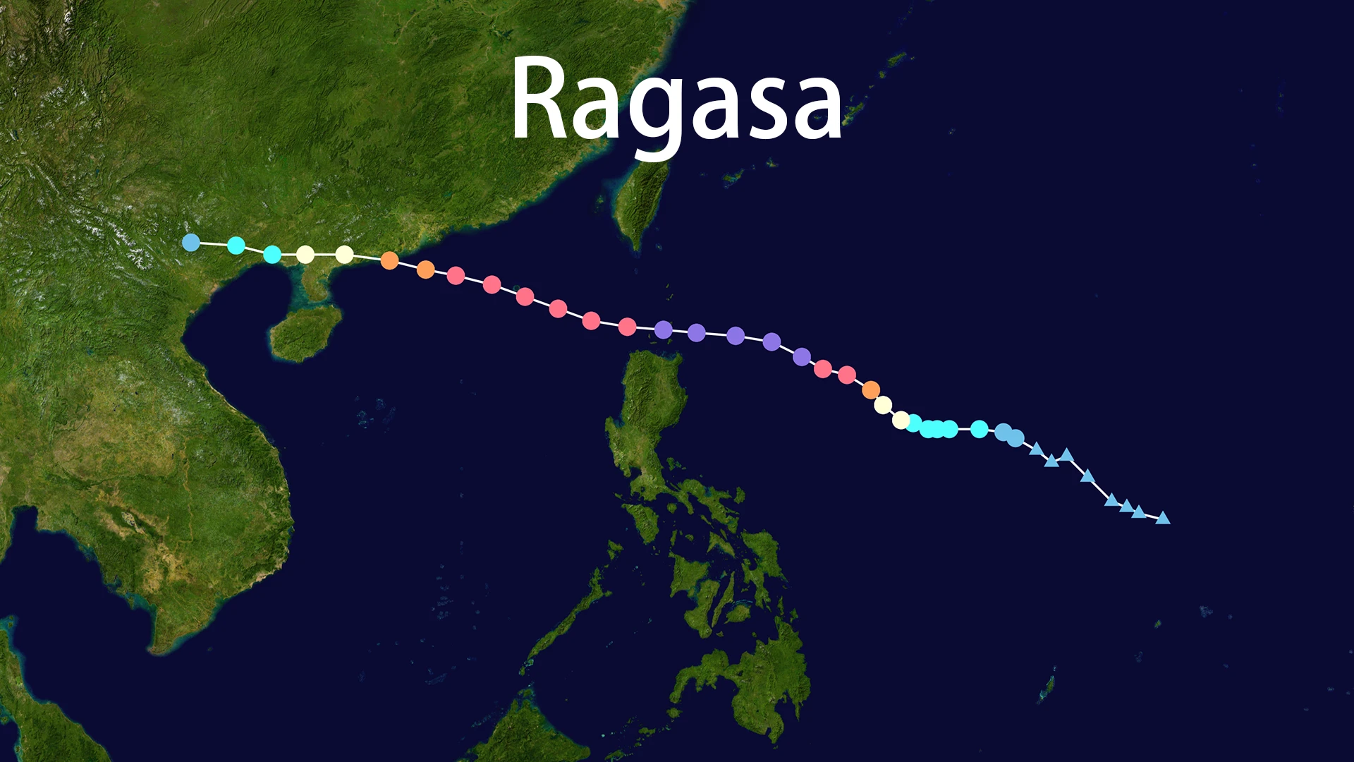
The origins of Typhoon Ragasa can be traced to a convective area north of Yap in Micronesia around September 16-17, 2025 . This disturbance quickly organized, and by September 18, it had been designated a tropical storm named Ragasa by the Japan Meteorological Agency (JMA) . The name, provided by the Philippines, means "rapid movement" or "to rush" in Tagalog, a moniker that proved eerily accurate .
What followed was a period of explosive intensification that stunned meteorologists. Typhoon Ragasa benefited from a perfect cocktail of favorable conditions: ocean temperatures exceeding 29°C, abundant moisture from the Southwest Monsoon, and low vertical wind shear . This allowed the storm to transform from a tropical storm into a super typhoon in a remarkably short timeframe. By September 21, Super Typhoon Ragasa had achieved maximum sustained winds estimated at 265 km/h (165 mph), with gusts even higher, placing it firmly in the Category 5 equivalent on the Saffir-Simpson scale . At its peak, its minimum central pressure plummeted to approximately 905-910 hPa, making it the most intense tropical cyclone of the 2025 season globally . The sheer speed of this transformation was a key characteristic of the Ragasa typhoon event.
A Path of Destruction: The Typhoon's Timeline and Landfalls
Typhoon Ragasa tracked a west-northwesterly path, consistently threatening densely populated coastal regions. Its first significant impact was on the Philippines. On September 22, the powerful Typhoon Ragasa made landfall on Panuitan Island in the Babuyan Islands, bringing destructive winds and torrential rain to northern Luzon . It exacerbated existing flooding from the monsoon season, causing landslides and widespread power outages .
The storm then swept past Taiwan, though it did not make a direct landfall. Its outer bands delivered torrential rains that triggered a secondary disaster: the overflow of a barrier lake in Hualien County . This event unleashed a devastating wall of water into Guangfu township, causing significant casualties and destruction, with the death toll in Taiwan reported to be between 14 and 17 people .
Next in the path of Typhoon Ragasa was Hong Kong. On September 24, the storm skirted south of the financial hub, but its immense size meant the city felt its full fury . Hong Kong's observatory issued high-level typhoon signals as the city was battered by waves "taller than lampposts" . Videos circulated online showing storm surges shattering the glass doors of an oceanside hotel and flooding its lobby . Over 90 people were treated for injuries in the city, primarily from fallen trees and wind-blown debris .
Finally, on the afternoon of September 24, Typhoon Ragasa slammed into southern China's Guangdong province, making landfall on Hailing Island near Yangjiang City . While it had weakened from its super typhoon peak to a severe typhoon at landfall, it still packed maximum sustained winds of around 145-175 km/h (90-109 mph) . The storm continued inland, weakening further as it moved toward Vietnam .
Assessing the Impact: Human and Economic Toll
The impact of Typhoon Ragasa was profound and multifaceted, affecting millions across the region.
Humanitarian Crisis: The typhoon resulted in a tragic loss of life. In the Philippines, at least 10 deaths were reported . Taiwan suffered the heaviest casualties, with at least 14-17 fatalities due to the barrier lake flood in Hualien . In China, the massive evacuation of nearly 1.9 million people in Guangdong province alone likely prevented a higher death toll, though injuries were reported .
Economic and Infrastructure Damage: The storm left a trail of damaged infrastructure. Cities in Guangdong saw uprooted trees, damaged power lines, and widespread flooding . The supply chain disruption was significant, with over a million businesses potentially affected as ports, airports, and factories from the Philippines to Southern China were forced to suspend operations . The economic cost is expected to run into billions of dollars.
Effective Disaster Response: Despite the destruction, the event highlighted improvements in disaster management. China's Central Government allocated millions for relief efforts . Utility companies in Guangdong deployed over 50,000 personnel to restore power to nearly 90% of affected users within a day of landfall . Insurance companies also activated fast-track claims processes to aid recovery . The scale of evacuations, one of the largest in recent memory for Southern China, was a crucial factor in mitigating the human cost of the disaster .
Lessons from the Storm: Preparedness in a Changing Climate
Typhoon Ragasa served as a stark reminder of the vulnerabilities faced by coastal megacities in the era of climate change. Meteorologists noted that its rapid intensification was fueled by unusually warm ocean waters, a condition increasingly linked to a warming climate . While no single weather event can be attributed solely to climate change, the behavior of storms like Typhoon Ragasa aligns with scientific predictions of more intense tropical cyclones.
The event also underscored the importance of robust early warning systems and public compliance with evacuation orders. The relatively lower number of direct deaths in China, compared to the storm's intensity, can be attributed to these coordinated efforts . However, the tragedy in Taiwan, where questions were raised about the effectiveness of evacuation warnings for the barrier lake, shows that communication and public trust remain critical challenges . The story of Typhoon Ragasa is not just about a powerful storm; it is a case study in how societies can build resilience against an increasingly volatile climate. The legacy of Typhoon Ragasa will undoubtedly influence disaster preparedness strategies for years to come.