

Typhoon Halong: The 2025 Pacific Storm That Bridged Continents
In the annals of Pacific typhoon history, Typhoon Halong stands out not just for its formidable strength but for its remarkable journey across ocean basins. The 22nd named storm of the 2025 season, Typhoon Halong demonstrated how a tropical system's influence can extend thousands of miles beyond its point of origin, leaving a trail of impacts from Japan's volcanic islands to the remote coasts of western Alaska. This is the complete story of a cyclone that refused to fade away quietly, transforming instead into a different kind of weather monster.
The Genesis and Meteoric Rise of a Pacific Giant
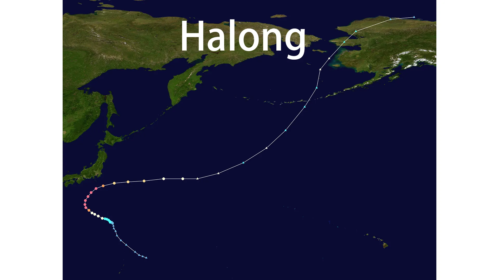
The story of Typhoon Halong began inconspicuously on October 3, 2025, as a broad area of convection swirling approximately 489 kilometers southeast of Iwo Jima. Under marginally favorable conditions with warm sea surface temperatures of 28-29°C, the system steadily organized. By October 4, the Japan Meteorological Agency (JMA) had classified it as a tropical depression, and the Joint Typhoon Warning Center (JTWC) soon issued a Tropical Cyclone Formation Alert. The system was named Tropical Storm Halong on October 5, inheriting its title from Vietnam's famed Ha Long Bay.
What followed was a textbook case of rapid intensification that meteorologists watch with both awe and concern. Fueled by exceptionally low wind shear and high ocean heat content, Typhoon Halong developed a distinctive "stadium effect" eye surrounded by deep convection. Within just 48 hours, it exploded from a tropical storm into a powerful Category 4 super typhoon, peaking on October 8 with 1-minute sustained winds of 215-225 km/h (130-140 mph) and a central pressure of 935 hPa. Satellite imagery from this period captured a perfectly symmetrical storm with cloud tops colder than -80°C in the eyewall—a signature of extreme intensity.
The Complex Path of Typhoon Halong
The trajectory of Typhoon Halong followed a classic recurvature pattern, though with distinctive nuances that determined its far-reaching impacts. Initially tracking northwestward under the influence of a subtropical ridge, Typhoon Halong began its anticipated turn toward the northeast on October 7-8 as the ridge weakened and a mid-latitude trough approached from the west.
This steering pattern brought the powerful core of Typhoon Halong dangerously close to Japan's Izu Islands, with the center passing approximately 100-150 kilometers south of Hachijō-jima on October 9. The storm then accelerated eastward into the open Pacific, avoiding direct landfall on mainland Japan but setting the stage for its subsequent transformation. The table below chronicles the key milestones in the evolution of Typhoon Halong:
| Date (2025) | Time (UTC) | Position (Lat/Lon) | 1-min Sustained Winds (mph/km/h) | Pressure (hPa) | Category (SSHWS) |
|---|---|---|---|---|---|
| Oct 4 | 18:00 | 22.5°N, 145.0°E | 35 / 55 | 1004 | Tropical Depression |
| Oct 5 | 00:00 | 23.0°N, 144.5°E | 45 / 75 | 998 | Tropical Storm |
| Oct 6 | 12:00 | 25.5°N, 142.0°E | 75 / 120 | 980 | Typhoon (Cat 1) |
| Oct 7 | 18:00 | 28.0°N, 140.0°E | 115 / 185 | 950 | Cat 3 |
| Oct 8 | 06:00 | 31.5°N, 138.5°E | 130 / 210 | 940 | Cat 4 (Peak) |
| Oct 9 | 00:00 | 32.5°N, 139.4°E | 110 / 175 | 946 | Cat 3 |
| Oct 10 | 00:00 | 34.4°N, 154.8°E | 80 / 130 | 975 | Cat 1 (Weakening) |
| Oct 10 | 12:00 | 35.0°N, 162.0°E | 60 / 95 | 980 | Extratropical |
Direct Impacts: Japan's Brush with the Storm
While Typhoon Halong never made direct landfall in Japan, its close passage produced significant impacts that highlighted the dangers of even a near-miss typhoon. The Izu Islands bore the brunt of the storm's fury, with Hachijō-jima experiencing particularly extreme conditions. The island recorded wind gusts reaching 198 km/h (123 mph) and a staggering 349 mm (13.7 inches) of rainfall, including a record-breaking 207 mm (8.15 inches) that fell in just three hours—the highest such accumulation ever documented in the area.
The effects on local infrastructure were severe. Flash flooding rendered roads impassable, while downed trees and power lines left approximately 2,200 residents without electricity. Another 2,700 customers lost access to clean water as treatment systems were compromised. Perhaps most tragically, the powerful waves generated by Typhoon Halong claimed one life, underscoring the often-underestimated danger of marine impacts even from a distant storm. Transportation networks were severely disrupted, with multiple flight cancellations between Tokyo's Haneda Airport and the islands, along with suspended ferry services that isolated communities for days.
An Unexpected Second Act: Alaska's Encounter with Halong's Remnants
The most remarkable chapter in the story of Typhoon Halong began as the storm weakened and underwent extratropical transition on October 10. Rather than dissipating, the system merged with a frontal boundary and transformed into a potent bomb cyclone that raced across the North Pacific. This regenerated system carried the residual energy of Typhoon Halong directly toward western Alaska, where it would create a historic weather disaster.
On October 11-12, the remnants of Typhoon Halong battered the Yukon-Kuskokwim Delta and Norton Sound regions with hurricane-force winds and catastrophic storm surges. Wind gusts exceeded 160 km/h (100 mph), with the Kusilvak Mountains recording a remarkable 172 km/h (107 mph). Storm surges reached 2-4.4 meters (7-14.5 feet), pushing water levels 1.8-2 meters (6-6.6 feet) above mean higher high water—shattering previous records in communities like Kipnuk.
The human toll was significant. Entire homes were swept from their foundations in villages like Kipnuk and Kwigillingok, forcing nearly 900 residents to evacuate to emergency shelters. First responders conducted over 50 rescues, plucking residents from flooded buildings and precarious situations. Despite extensive searches, three people remained missing in Kwigillingok in the immediate aftermath. The disaster prompted Alaska Governor Mike Dunleavy to expand a state disaster declaration and activate up to 60 National Guard members, while the U.S. Coast Guard and Alaska State Troopers coordinated complex rescue operations across the vast, roadless region.
Meteorological Significance and Climate Connections
The journey of Typhoon Halong from tropical cyclone to extratropical storm system offers a compelling case study in tropical-extratropical interactions. Meteorologists noted that the storm's ability to transfer its energy to a mid-latitude system demonstrated how tropical cyclones can influence weather patterns across hemispheric scales. The event highlighted the growing understanding that a typhoon's impacts don't necessarily end when it loses its tropical characteristics.
Within the context of the active 2025 Pacific typhoon season, which saw 35 systems including destructive storms like Matmo and Nakri, Typhoon Halong stood out for its rapid intensification and extraordinary reach. While its peak winds were below the season's maximum, the storm's transformation and subsequent impacts on Alaska underscored the complex ways in which tropical systems interact with broader atmospheric patterns. Some climate scientists have suggested that warming ocean temperatures may enhance such distant effects, potentially making events like the Alaska flooding more frequent in future seasons.
The Legacy of Typhoon Halong
The complete narrative of Typhoon Halong serves as a powerful reminder of nature's interconnectedness and the unpredictable character of tropical cyclones. From its formation in the Philippine Sea to its devastating final act in Alaska, the storm exemplified how meteorological systems can evolve, transform, and surprise. The dual impacts of Typhoon Halong—both in its tropical phase in Japan and its extratropical phase in Alaska—highlight the importance of comprehensive forecasting that looks beyond traditional cyclone tracks and anticipates secondary impacts across ocean basins. For residents of both the Izu Islands and western Alaska, the name Halong will long be remembered as a force of nature that bridged continents and demonstrated the awesome power of our planet's weather systems.