

Hurricane Priscilla: Tracing the Path of Destruction Across Mexico and the American Southwest
In the volatile 2025 Pacific hurricane season, Hurricane Priscilla emerged as a formidable force, capturing the attention of meteorologists and residents from Mexico to the American Southwest. This powerful weather system demonstrated nature's unpredictable fury, transitioning from a Category 2 hurricane to a remnant low that continued to wreak havoc long after losing its formal structure. The story of Hurricane Priscilla serves as a sobering reminder of how tropical systems can influence weather patterns thousands of miles from their origin.
The Birth and Evolution of a Powerful Storm
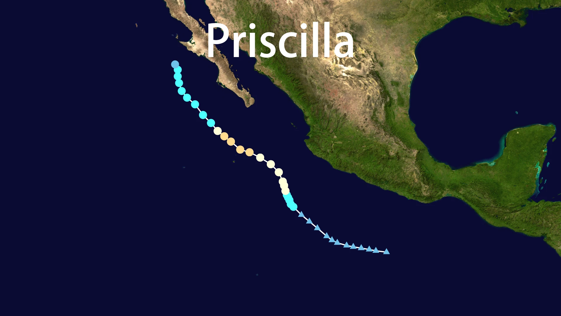
Hurricane Priscilla began as an unassuming tropical depression on October 4, 2025, in the warm waters of the Eastern Pacific. Meteorological conditions proved ideal for rapid intensification, with minimal wind shear and exceptionally warm sea surface temperatures fueling its development. Within days, the system transformed into Tropical Storm Priscilla, becoming the sixteenth named storm of the active 2025 season.
The transformation of Hurricane Priscilla into a major weather event occurred with startling speed. By October 6-7, satellite imagery revealed a well-defined eye structure approximately 50 nautical miles in diameter, surrounded by intense convection. Hurricane Priscilla reached its peak intensity as a Category 2 hurricane with sustained winds of 110 mph and gusts reaching 130 mph. Some analysis suggested Hurricane Priscilla came remarkably close to Category 3 status, missing the threshold by just 1 mph.
Tracking Hurricane Priscilla's Path of Destruction
The journey of Hurricane Priscilla followed a northwest trajectory parallel to the Mexican coastline before making landfall near the southern tip of Baja California on October 9. Although Hurricane Priscilla had weakened to tropical storm strength at landfall, its impacts extended far beyond the immediate coastal regions.
The following table illustrates key milestones in Hurricane Priscilla's lifecycle:
| Date & Time (UTC) | Status | Sustained Winds | Pressure | Location |
|---|---|---|---|---|
| October 4, 2025 | Tropical Depression | <39 mph | N/A | Eastern Pacific |
| October 6, 2025 | Tropical Storm | 39-73 mph | 1003 hPa | 13.3°N 51.6°W |
| October 7, 2025 | Category 2 Hurricane | 110 mph | 958 hPa | 20.3°N 111.2°W |
| October 9, 2025 | Tropical Storm | 65 mph | 982 hPa | Baja Landfall |
| October 12, 2025 | Post-Tropical | <39 mph | N/A | Dissipated |
Devastating Impacts Across Mexico
The legacy of Hurricane Priscilla in Mexico tells a story of destruction spanning coastal and inland communities. Coastal regions including Jalisco, Nayarit, and Sinaloa experienced the initial brunt of Hurricane Priscilla's fury. In Puerto Vallarta, massive waves reaching 4 meters battered coastal infrastructure, damaging seawalls, beachfront restaurants, and popular boardwalks. The fishing industry suffered significant disruptions as shrimp fleets in Mazatlán remained docked throughout the storm.
As Hurricane Priscilla moved inland, its interaction with Tropical Storm Raymond created a meteorological nightmare, pumping exceptional moisture into central Mexican states. The resulting torrential rains triggered catastrophic flooding and landslides across Veracruz, Hidalgo, Puebla, and Querétaro. Tragically, these weather events claimed at least 44 lives, with Veracruz reporting 18 fatalities and Hidalgo 16. Countless communities faced destroyed infrastructure, submerged homes, and severed transportation routes.
Hurricane Priscilla's Unexpected Reach into the American Southwest
Perhaps the most remarkable aspect of Hurricane Priscilla was its ability to influence weather patterns across the American Southwest long after the storm itself had dissipated. The remnant moisture from Hurricane Priscilla traveled northward, combining with existing weather systems to produce widespread rainfall from October 9-12.
Arizona experienced the most significant impacts, with Phoenix and surrounding areas recording 2-3 inches of rainfall—equivalent to a typical month's precipitation. The deluge transformed streets into rivers, forced road closures, and overwhelmed drainage systems. Gila County communities including Globe and Miami faced repeated flooding incidents, compounding recovery efforts.
Utah's renowned national parks, including Zion and Bryce Canyon, faced elevated flash flood risks as Hurricane Priscilla's remnants saturated the landscape. The National Weather Service issued multiple flood watches, particularly concerned about vulnerable burn scar areas where vegetation loss increased landslide potential. Colorado and New Mexico also received substantial precipitation from the dying breaths of Hurricane Priscilla.
Emergency Response and Recovery Efforts
The widespread impacts of Hurricane Priscilla prompted coordinated emergency responses across affected regions. Mexican authorities activated comprehensive emergency plans, deploying military assets for evacuation missions and delivering critical supplies to isolated communities. The U.S. Embassy issued detailed safety advisories, emphasizing the increased risks of landslides and flash flooding in vulnerable areas.
Local governments in Arizona implemented practical measures including park closures and sandbag distribution points. The enduring lesson from Hurricane Priscilla reinforced the critical importance of heeding evacuation orders and avoiding floodwaters—both on foot and in vehicles.
Meteorological Legacy and Climate Connections
Hurricane Priscilla provided valuable insights into how tropical systems transport moisture across continental distances. The storm's ability to generate significant rainfall in arid regions like Arizona demonstrated the far-reaching consequences of Pacific hurricanes. Meteorologists noted that Hurricane Priscilla's behavior aligned with patterns suggesting more frequent moisture transport events in warming climate scenarios.
The back-to-back occurrence of Hurricane Priscilla and Tropical Storm Raymond highlighted the increasingly active nature of Pacific hurricane seasons, with some researchers suggesting connections to broader climate patterns influencing storm frequency and intensity.
Conclusion: Remembering Hurricane Priscilla
While Hurricane Priscilla no longer appears on weather maps, its impacts continue to resonate throughout affected communities. The storm's journey from powerful hurricane to remnant low illustrates the complex life cycles of tropical systems and their capacity to influence weather far beyond their original boundaries. As reconstruction continues across Mexico and the American Southwest, the name Hurricane Priscilla will remain etched in meteorological history as a powerful example of nature's interconnected weather systems and the importance of preparedness in an era of changing climate patterns.