
Hurricane Humberto: The Category 5 Storm That Danced Over the Atlantic
Introduction: A Powerful but Distant Storm
In late September 2025, the Atlantic Ocean bore witness to the raw power of nature as Hurricane Humberto rapidly intensified into a Category 5 storm—the highest classification on the Saffir-Simpson scale. With maximum sustained winds reaching 160 mph (approximately 260 km/h), Humberto became the second Category 5 hurricane of the highly active 2025 Atlantic season . Despite its tremendous power, this iteration of Humberto remained primarily over open waters, never making landfall but still generating significant impacts across the Caribbean, Bermuda, and the U.S. East Coast through dangerous marine conditions.
The story of Humberto is not just one of intensity, but also of fascinating meteorological interactions. This powerful system engaged in a rare atmospheric dance with another storm—Hurricane Imelda—through the Fujiwhara effect, ultimately steering both on paths that minimized direct impacts to populated areas . This comprehensive profile details the lifecycle, impacts, and significance of this remarkable storm.
Formation and Meteorological History
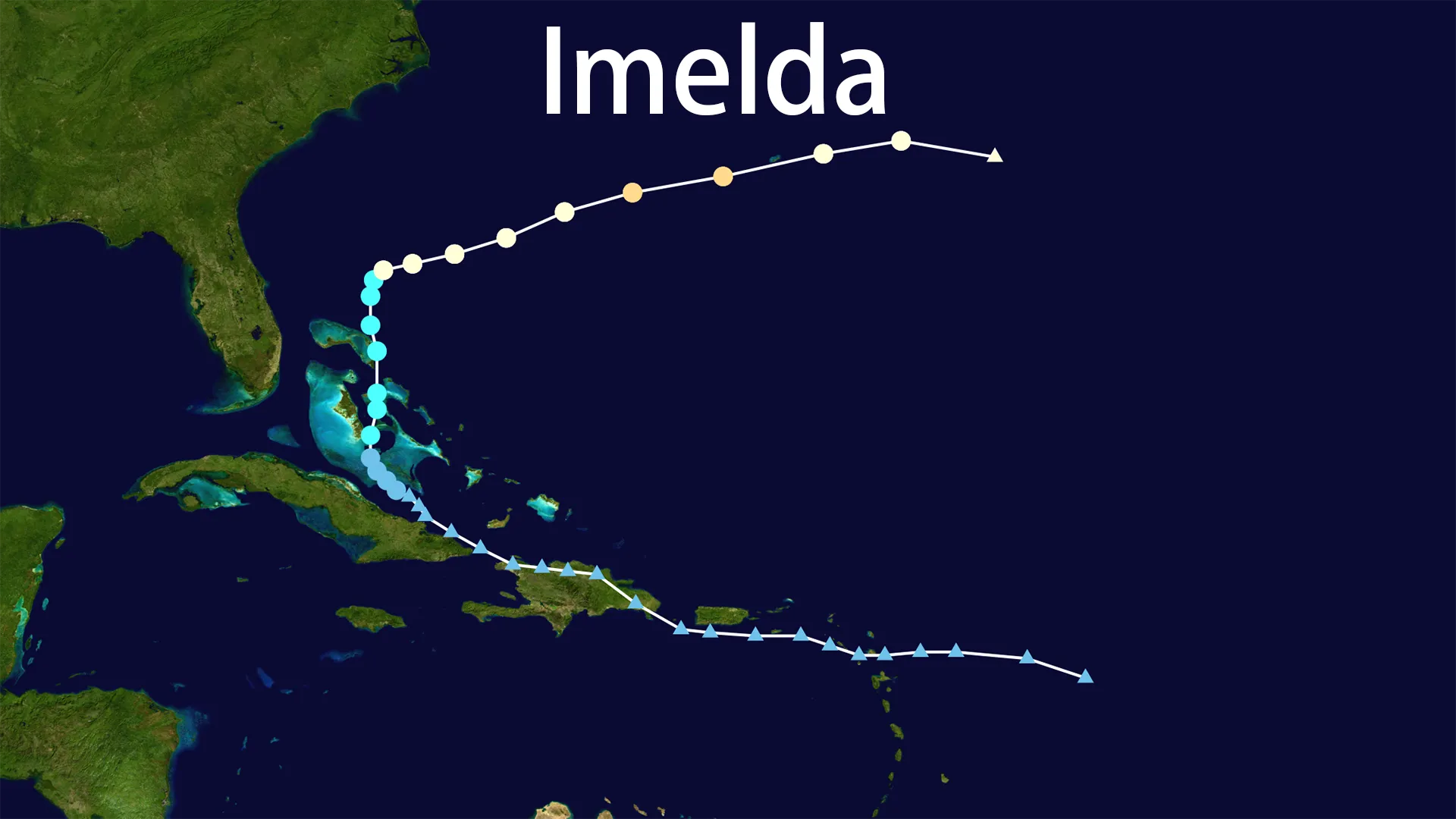
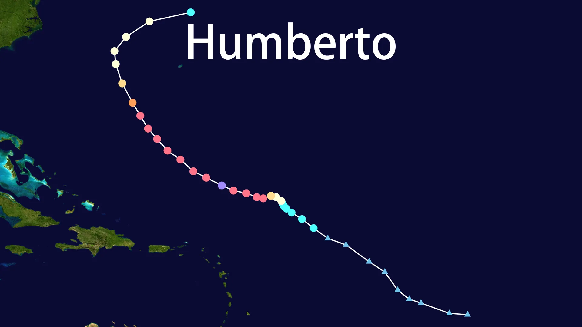
Hurricane Humberto began as a tropical storm on September 25, 2025, forming approximately 775 miles east-northeast of the Northern Leeward Islands . Initially characterized by maximum sustained winds of 45 mph, the system moved northwest at about 10 mph through favorable environmental conditions including warm ocean waters and low wind shear .
The storm underwent rapid intensification, reaching hurricane status by September 27 and eventually peaking as a Category 5 monster with winds up to 160 mph (260 km/h) on September 28 . This explosive strengthening was fueled by ocean temperatures approximately 1°C above average, with high ocean heat content at depth providing ample energy . Meteorologists noted that Humberto marked a significant milestone—the first time since 1935 that the first three hurricanes of an Atlantic season had reached such high intensities .
Following its peak, Humberto began a gradual weakening process, decreasing to Category 4 status by September 29 with winds of approximately 140 mph . The storm continued to lose strength as it encountered less favorable conditions, dropping to Category 1 status with 80 mph winds by October 1 before ultimately being absorbed by a frontal system and transitioning into a powerful extratropical cyclone .
Path and Movement
Throughout its existence, Humberto followed a generally predictable path that kept it primarily over open waters. Initially moving toward the northwest, the storm gradually curved northward before eventually turning northeast and accelerating away from land areas .
By September 29, the center of Humberto was positioned about 320 miles southwest of Bermuda . The storm continued tracking northwest of the island territory, passing approximately 280 miles north-northwest of Bermuda by October 1 . This path brought the powerful hurricane close enough to generate significant impacts on Bermuda while keeping the most destructive winds safely offshore.
The northeastward turn late in Humberto's lifecycle eventually carried the storm into the North Atlantic, where it merged with a frontal boundary and completed its transition to a post-tropical system . Throughout this journey, forecast models consistently predicted that Humberto would remain over water, providing crucial lead time for preparations in potentially affected areas.
Intensity and Peak Strength
Hurricane Humberto achieved its maximum intensity on September 28, 2025, reaching Category 5 status with sustained winds of 160 mph (260 km/h) . Different sources reported minimum central pressures ranging from 937 mb to as low as 924 mb at the storm's peak . This placed Humberto among the most intense Atlantic hurricanes on record, though it fell short of the all-time pressure record held by Hurricane Wilma (2005).
The storm's rapid intensification was particularly notable, with wind speeds increasing well beyond the threshold that defines rapid intensification (≥56 km/h in 24 hours) . This explosive development pattern has become increasingly common in the context of warming ocean temperatures, though Humberto's specific case was exceptional even by modern standards.
Following its peak, Humberto underwent the more typical lifecycle of a major hurricane, including eyewall replacement cycles that caused fluctuations in intensity before the overall weakening trend took hold . By October 1, the storm had diminished to Category 1 status with maximum sustained winds of 80 mph before completing its transition to a post-tropical cyclone .
Impacts and Effects
Despite remaining offshore, Hurricane Humberto generated widespread impacts across the western Atlantic region:
Marine and Coastal Impacts
The most significant effects came in the form of dangerous marine conditions. The National Hurricane Center warned that Humberto would generate "life-threatening surf and rip current conditions" along the U.S. East Coast, affecting beaches from Florida to New England . These conditions emerged as swells radiated outward from the storm's center, traveling hundreds of miles to reach coastline.
Similar marine hazards affected the northern Leeward Islands, Virgin Islands, Puerto Rico, and the Bahamas . Authorities in these regions issued small craft advisories and warned residents and visitors to exercise extreme caution in coastal areas.
Effects on Bermuda
As the closest landmass to Humberto's track, Bermuda experienced direct impacts from the powerful hurricane. The island was placed under a Tropical Storm Watch as the storm approached . While the center of Humberto remained offshore, the system still brought periods of heavy rainfall (1-2 inches) and the potential for tropical storm-force winds to the territory .
Bermuda's emergency management agencies activated storm preparedness procedures, with officials urging residents to secure property and monitor forecast updates closely . The close approach of Humberto followed shortly by Hurricane Imelda created an extended period of hazardous conditions around the islands .
Interaction with Hurricane Imelda
One of the most remarkable aspects of Hurricane Humberto was its interaction with nearby Tropical Storm (later Hurricane) Imelda. The two systems drew close enough to engage in the Fujiwhara effect—a rare phenomenon where cyclones orbit around a common center .
Meteorologists observed that the stronger Humberto ultimately dominated this interaction, tugging Imelda into its wake and pulling it away from the U.S. coastline. Steven Taylor, a lead meteorologist with the National Weather Service in Charleston, explained the dynamic: "If Humberto was not part of the equation, the general wind flow would've been dominated by that upper low over the Carolinas". Instead, Humberto's intensity shifted the atmospheric balance, ultimately sparing the Lowcountry region from a potential direct impact by Imelda.
The Fujiwhara Effect: A Rare Meteorological Dance
The interaction between Hurricane Humberto and Hurricane Imelda represented a particularly notable example of the Fujiwhara effect in the Atlantic Basin. This phenomenon occurs when two tropical cyclones pass close enough to each other to begin orbiting around a shared center .
The effect is named after Sakuhei Fujiwhara, the Japanese meteorologist who first described the motion of vortices in water in 1921 . In the case of Humberto and Imelda, the stronger Humberto essentially dictated the terms of engagement, with the weaker Imelda being drawn into its circulation.
This wasn't the first time a storm named Humberto had participated in such a dance—back in 1995, another Hurricane Humberto had interacted with Hurricane Iris in a similar fashion . The 2025 iteration, however, featured a much more powerful Humberto that dominated the interaction rather than weakening as its predecessor had.
Meteorologists noted that the Fujiwhara effect occurs relatively rarely in the Atlantic, primarily because tropical systems typically don't pass close enough to interact so dramatically . The specific distance required depends on the size of the storms, with larger systems like Humberto capable of influencing others within approximately 850 miles .
Historical Context and Comparison
The 2025 Hurricane Humberto marked the sixth use of the name since it replaced the retired "Hugo" following the destructive 1989 season . Previous storms named Humberto have varied significantly in intensity and impacts, ranging from relatively minor systems to damaging landfalling hurricanes.
The 2025 version of Humberto distinguished itself as the most intense bearing that name, and joined a select group of Atlantic hurricanes that reached Category 5 status without making landfall . This placed it in the company of storms like Hurricane Lorenzo (2019) and Hurricane Lee (2023), which similarly spent their entire lifecycles over water.
Humberto was also notable for being part of a remarkably active start to the 2025 hurricane season, which saw multiple major hurricanes developing in quick succession . Meteorologist Philip Klotzbach of Colorado State University noted that 2025 marked the first time since 2015 that the first three hurricanes of a season had all reached major hurricane status (Category 3 or higher) .
The storm's behavior fit into broader patterns of increasingly rapid intensification observed in recent years, a trend that scientists have linked to rising ocean temperatures driven by climate change .
Preparation and Response
Emergency management officials across the western Atlantic monitored Hurricane Humberto closely as the storm intensified and moved through the region. While the storm's offshore track minimized the need for large-scale evacuations, authorities still took proactive measures to ensure public safety.
In Bermuda, government agencies implemented standard storm preparedness procedures, urging residents to secure property and review emergency plans . The close approach of two hurricanes—Humberto followed by Imelda—created particular challenges for emergency managers, who had to prepare for potential impacts from both systems in quick succession .
Along the U.S. East Coast, the primary focus was on marine hazards rather than wind or rainfall impacts. Beach safety officials raised flags warning of dangerous rip currents, while the National Weather Service issued frequent updates on coastal conditions . These warnings proved crucial, as rip currents generated by distant hurricanes represent one of their most consistent and widespread threats to human life.
The successful tracking and prediction of Humberto's path demonstrated continued improvements in hurricane forecasting, particularly regarding the complex interactions between multiple storm systems. Meteorologists credited enhanced data collection—including additional weather balloons launched to sample the atmosphere—with improving forecast accuracy during the complex dance between Humberto and Imelda.
Conclusion: Significance and Legacy
Hurricane Humberto of 2025 will be remembered as a powerful Category 5 storm that fortunately remained over open waters for its entire lifecycle. While the system never made landfall, it still generated significant impacts through dangerous marine conditions across the western Atlantic .
The storm provided a dramatic example of the Fujiwhara effect in action, demonstrating how tropical cyclones can interact in ways that significantly alter their paths . In this case, Humberto's strength ultimately steered Hurricane Imelda away from the U.S. coastline, sparing coastal communities from potential direct impacts.
Humberto also highlighted ongoing trends in hurricane behavior, particularly the increasing frequency of rapid intensification episodes linked to warmer ocean temperatures . As climate change continues to influence tropical cyclone development, storms like Humberto may become more common—making understanding their behavior increasingly important for forecasters and emergency managers.
While the 2025 Hurricane Humberto caused minimal damage and no reported fatalities, its tremendous power served as a reminder of nature's capacity for violence—and the critical importance of continued investment in hurricane research, forecasting, and preparedness, even for storms that remain safely offshore.