
Hurricane Imelda: The Unpredictable Storm of the 2025 Season
In the annals of Atlantic hurricane history, Hurricane Imelda stands out as a testament to nature's unpredictability. As the ninth named storm and fourth hurricane of the hyperactive 2025 season, Hurricane Imelda captured meteorologists' attention with its rapid intensification and unexpected path. Forming on September 27, 2025, between Cuba and the Bahamas, Hurricane Imelda began as a tropical disturbance that swiftly evolved into a formidable force. Over the following days, Hurricane Imelda would reach Category 2 status, with peak sustained winds of 100 mph, before barreling toward Bermuda and leaving a trail of impacts across the Caribbean and U.S. coastline. The story of Hurricane Imelda is not just one of wind and rain, but of how atmospheric interactions—like the rare Fujiwhara effect with Hurricane Humberto—steered its destiny, averting a potential U.S. landfall while testing the resilience of island communities.
The Genesis and Evolution of Hurricane Imelda
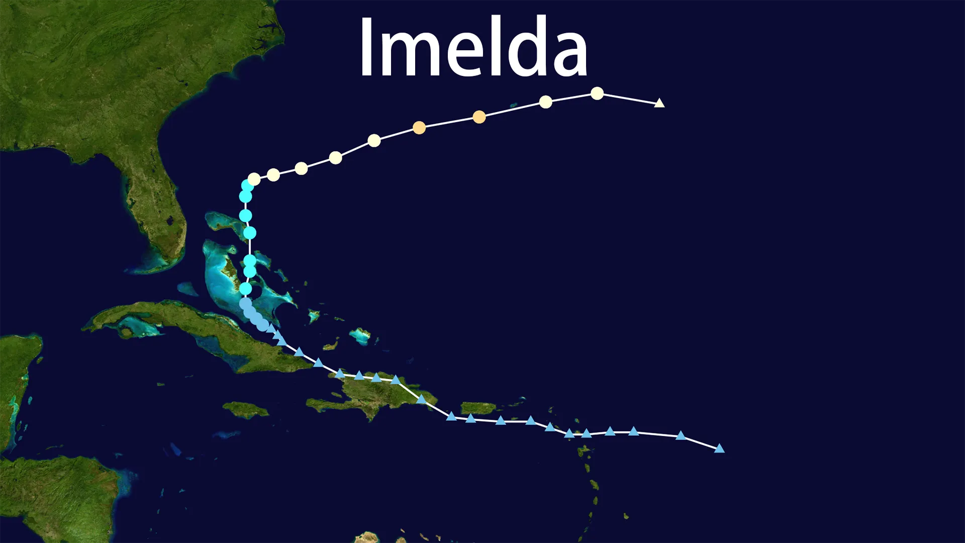
Hurricane Imelda originated from a tropical wave that the National Hurricane Center (NHC) first flagged as Invest 93L on September 26. By September 27, it had consolidated into Tropical Depression Nine near the waters east of Cuba, with initial winds of 35 mph. Warm sea surfaces and low wind shear allowed the system to thrive, and by September 28, it strengthened into Tropical Storm Imelda while positioned about 370 miles southeast of Florida. As Hurricane Imelda tracked northward through the Bahamas, it underwent a period of rapid intensification, fueled by convective reorganization and ideal oceanic conditions. On September 30, reconnaissance flights confirmed that Hurricane Imelda had become a Category 1 hurricane, with winds escalating to 85 mph. The storm's climax arrived on October 1, when Hurricane Imelda achieved its peak as a Category 2 hurricane, boasting 100 mph winds and a central pressure of 966 mb. This phase of Hurricane Imelda was marked by a distinct eye visible in satellite imagery, showcasing its organized structure. However, Hurricane Imelda's lifecycle was cut short by its interaction with the larger Hurricane Humberto; by October 2, it had transitioned into a post-tropical cyclone, accelerating northeastward over the open Atlantic and dissipating without further threat to land.
The Path and Intensity: A Dance with Destiny
The trajectory of Hurricane Imelda was a meteorological ballet, influenced by competing weather systems. Initially, Hurricane Imelda moved sluggishly northward, brushing the Bahamas and prompting tropical storm warnings for Florida's coast. However, the storm's path took a dramatic turn east-northeastward, driven by the steering currents of Hurricane Humberto—a powerful Category 4 storm to its west. This interaction, known as the Fujiwhara effect, caused the two hurricanes to orbit each other, effectively pulling Hurricane Imelda away from the U.S. mainland and toward Bermuda. On October 1, the core of Hurricane Imelda passed directly over Bermuda, lashing the island with hurricane-force winds and torrential rain. Throughout its journey, Hurricane Imelda maintained a compact structure, with hurricane-force winds extending up to 45 miles from its center. Intensity fluctuations were closely monitored by the NHC, which noted that Hurricane Imelda's peak as a Category 2 storm was brief but impactful, followed by a swift decline as it merged with extratropical systems. The legacy of Hurricane Imelda's path underscores the complexity of forecasting in an era of climate volatility, where overlapping storms can redefine risk in real time.
Impacts and Human Toll: Communities in the Crosshairs
The wrath of Hurricane Imelda was felt across multiple regions, each grappling with unique challenges. In the Caribbean, Hurricane Imelda' outer bands unleashed catastrophic flooding in eastern Cuba, where rainfall totals reached 300 mm. Tragically, two lives were lost to flash floods, and over 18,000 residents were evacuated from vulnerable areas like Guantánamo Province. Haiti also reported injuries and missing persons amid widespread inundation. As Hurricane Imelda advanced, the Bahamas faced tropical storm conditions, with schools shuttered and power outages disrupting daily life. But it was Bermuda that bore the brunt of Hurricane Imelda's fury. On October 1–2, the island endured sustained winds of 100 mph and gusts up to 105 mph, toppling trees and power lines. More than 18,000 households lost electricity, and 53 people sought refuge in emergency shelters. Despite the chaos, Bermuda's robust infrastructure and timely warnings prevented fatalities, though recovery efforts stretched for days. Along the U.S. East Coast, Hurricane Imelda's indirect effects were stark: dangerous rip currents and storm surge led to the collapse of five homes in North Carolina's Outer Banks, while coastal advisories urged vigilance from Florida to Maine. The aftermath of Hurricane Imelda serves as a reminder that even storms that avoid direct landfall can leave enduring scars.
Response and Recovery: Lessons from Hurricane Imelda
In the face of Hurricane Imelda, government agencies mounted coordinated responses to mitigate harm. Bermuda's Emergency Measures Organisation (EMO) activated ahead of the storm, closing airports and schools while deploying soldiers to secure infrastructure. Public advisories from the NHC kept residents informed, with social media playing a pivotal role in disseminating real-time updates. In Cuba, mass evacuations and pre-positioned emergency teams helped curb the death toll, though flooding exposed vulnerabilities in rural communities. The U.S. National Weather Service issued marine warnings that likely saved lives by deterring beachgoers from treacherous surf. Post-storm, Hurricane Imelda prompted reflections on climate resilience; for instance, Bermuda's energy provider worked tirelessly to restore power, highlighting the need for hardened grids in hurricane-prone zones. The relatively low economic damage from Hurricane Imelda—estimated in the millions—contrasts with more destructive storms, but its psychological impact lingers, especially among those who experienced its capricious nature.
Conclusion: The Legacy of Hurricane Imelda
Hurricane Imelda may not have been the strongest storm of 2025, but its story is etched in meteorological lore for its dynamic behavior and societal lessons. From its humble beginnings as a tropical wave to its climax as a Category 2 hurricane, Hurricane Imelda demonstrated how interconnected weather systems can alter destinies. For researchers, Hurricane Imelda offers a case study in the Fujiwhara effect and coastal resilience; for communities, it reinforces the importance of preparedness in an evolving climate. As the 2025 season waned, Hurricane Imelda left an indelible mark—a testament to nature's power and humanity's enduring spirit in the face of uncertainty.