
The Story of Hurricane Kiko: A Powerful Yet Gentle Giant of the 2025 Season
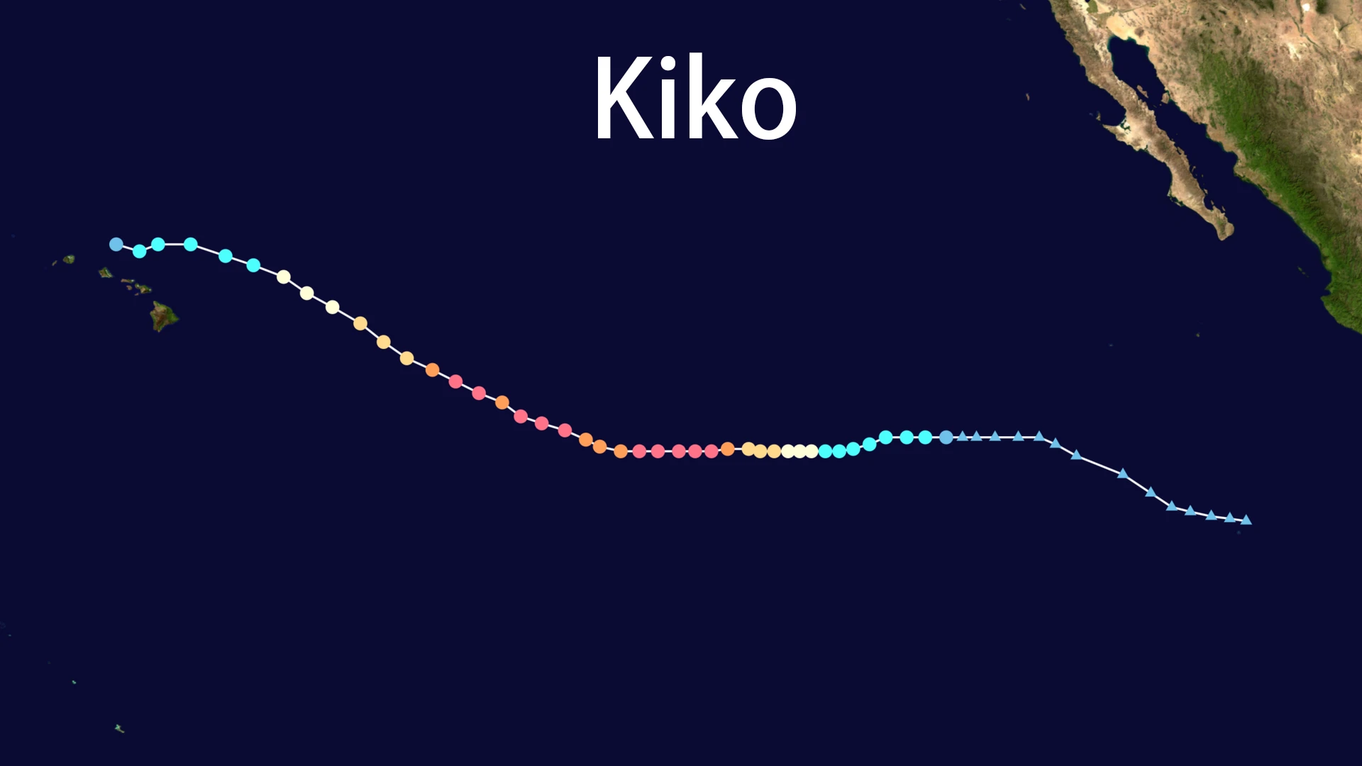
In the vast, warm waters of the Eastern Pacific, a atmospheric disturbance began to organize in late August 2025. This system, which would soon become the formidable Kiko, started its journey not with a roar, but with a whisper. By August 31st, the National Hurricane Center designated it as Tropical Depression Eleven-E. Fueled by ideal conditions—low wind shear and high ocean heat content—the depression rapidly intensified. Within hours, it earned its name: Tropical Storm Kiko.
The name Kiko was now officially on the board, a moniker that would come to represent one of the season's most intense, yet ultimately benign, meteorological events.
The Meteoric Rise to Fury
What followed was a period of explosive intensification that captured the attention of meteorologists worldwide. Kiko was a classic example of a storm thriving in a perfect environment. Within days, it transformed from a modest tropical storm into a behemoth.
By September 3rd, Kiko had achieved major hurricane status. Satellite imagery from NASA and NOAA revealed a stunningly symmetric storm with a well-defined eye, hallmarks of a severe cyclone. Kiko's peak was awe-inspiring; it reached Category 4 intensity on the Saffir-Simpson scale, with maximum sustained winds estimated at 145 mph (233 km/h) and a central pressure plummeting to 944 mb. For a short period, Kiko ranked as one of the most powerful storms of the 2025 Pacific season, its accumulated cyclone energy (ACE) a testament to its strength.
The Pivotal Turn: A Change of Heart
The narrative of Kiko took a critical turn as it churned westward. The forces that guided its path—the subtropical ridge and prevailing trade winds—steered it on a trajectory that would define its legacy. Instead of continuing toward land, Kiko began a northwesterly shift.
This path was its saving grace. As Kiko approached the Central Pacific and the Hawaiian Islands, it encountered its adversaries: cooler waters, drier mid-level air, and increasing wind shear. These factors began to dismantle the storm's impressive structure. The tight eye vanished, convection became erratic, and the symmetric core gave way to a exposed circulation. By September 8th, the mighty Kiko had been downgraded to a tropical storm. The storm that once threatened with Category 4 fury was now weakening rapidly.
Impacts: A Tale of What Could Have Been
The story of Kiko is a masterclass in how a storm's path is the ultimate arbiter of its impact. Despite its extreme power, Kiko's legacy is not one of destruction, but of a near-miss. Its primary impacts on Hawaii were indirect but significant:
- Dangerous Seas: The greatest threat came from massive swells generated by Kiko' vast wind field. Life-threatening surf of 10-20 feet pounded east-facing shores, triggering high surf warnings and prompting officials to plead with residents and tourists to stay out of the water due to deadly rip currents.
- Proactive Preparation: Heeding the forecasts, Hawaii's Acting Governor Sylvia Luke declared a state of emergency on September 5th. This proactive move activated the National Guard and freed up resources, showcasing a textbook example of effective emergency management based on uncertain forecasts.
- Minimal Rainfall: While Kiko brought some scattered showers and thunderstorms to the islands, no widespread flooding occurred. Its weakening state and northerly track spared the region from its former rain potential.
The Gentle Dissipation of Kiko
The final chapter for Kiko was written quietly. By September 10th, the National Hurricane Center issued its final advisory. Kiko was no longer a tropical cyclone but a post-tropical remnant low, centered about 110 miles north of Honolulu with winds of a mere 35 mph. Within days, the remnants of Kiko dissipated entirely over the open ocean, leaving only a memory and a series of fading swells.
Conclusion: The Paradox of Hurricane Kiko
Hurricane Kiko remains a fascinating paradox of the 2025 season—a powerhouse that did no power damage. Its story underscores a critical lesson in meteorology and disaster preparedness: intensity is only half the equation. Kiko's path was everything. It serves as a poignant reminder of nature's unpredictability and a case study in how prudent planning and a little luck can avert disaster.
The name Kiko will not be retired; it caused no significant damage or loss of life. It will cycle back onto the list in future years, a quiet testament to a gentle giant that roared loudly, but only over the open sea.