

Typhoon Krosa (2025): The Crane's Near-Flight Over Japan
The Triple Threat Emerges
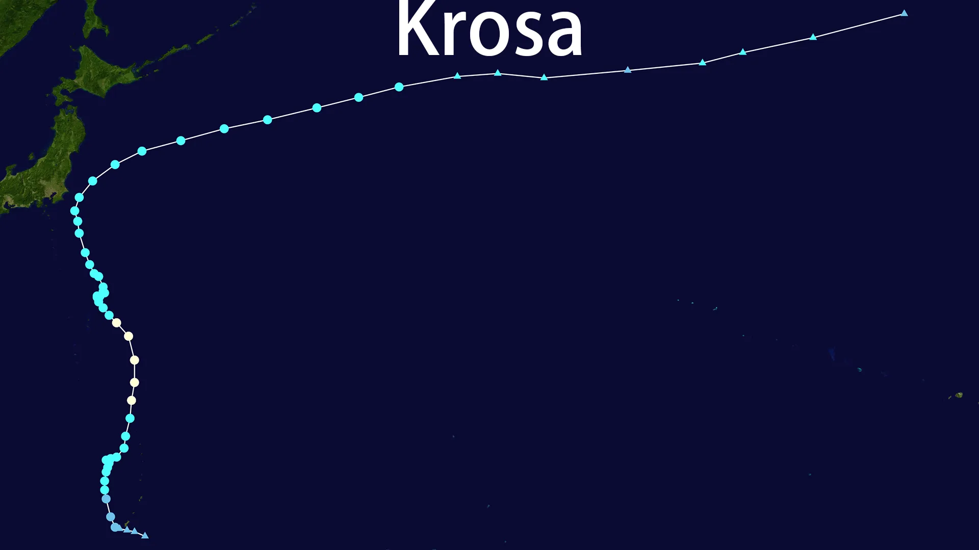
In the turbulent theater of July 2025's Pacific, Typhoon Krosa entered stage right as the third dancer in a rare meteorological ballet. While Typhoons F and G dominated headlines, the system designated 12W coalesced near Guam on July 23rd. Christened Krosa ("Crane" in Khmer) by the Japan Meteorological Agency (JMA) on July 24th, this avian-named storm would execute a graceful yet perilous flight path along Japan's doorstep.
The Crane's Fleeting Fury
Feasting on the Marianas' warm waters, Typhoon Krosa rapidly matured. By July 27th, satellite imagery revealed its most majestic form—a tightly wound core with 90 mph (145 km/h) winds circling a 965 hPa pressure eye. This Category 1 peak south of the Ogasawara Islands marked Typhoon Krosa's zenith. Yet even at full strength, dry air saboteurs and wind shear assassins were already gnawing at its structure. The crane's wings would soon be clipped.
Islands in the Storm's Shadow
The Ogasawaras felt Typhoon Krosa's breath first. On July 29th, Chichijima Island watched the storm's eye pass 120 km northeast, its shores battered by 5-meter waves. As Krosa weakened to a severe tropical storm, it turned toward the Izu archipelago. By July 31st, Hachijojima Island lay within its grasp, 200 km west of the churning center. Emergency alerts screamed warnings of 7-meter waves and 126 km/h gusts—the crane's feathers brushing the islands' nerves.
The Kanto Coastline Hold Its Breath
Tension peaked on August 1st as Typhoon Krosa performed its closest approach. 100 km east of Chiba's Boso Peninsula, the storm stirred the ocean into 6-meter monsters while drenching coastal towns with 100mm rains. In Tokyo, ANA flights to Hachijojima vanished from departure boards. Seawall gates slammed shut from Shimoda to Choshi. Yet in a display of meteorological poise, Typhoon Krosa maintained its offshore waltz—the crane's dance avoiding landfall by a feather's breadth.
The Dissipation Tango
Exhausted by its performance, Typhoon Krosa spun northeast into colder waters. On August 4th, the crane completed its final metamorphosis—shedding tropical characteristics to become a post-tropical cyclone. Its once-defined structure dissolved into the North Pacific's canvas, leaving only satellite memories of its 12-day performance.
Legacy of a Near-Miss
Typhoon Krosa's legacy is etched in relief:
- Zero casualties despite brushing Japan's most populated region
- Minimal damage limited to canceled flights and coastal warnings
- Monsoon enhancement that delivered manageable rains to the Philippines
- A masterclass in near-miss trajectory that spared mainland Japan
The crane's flight path—1,200 km from Guam to Chiba—served as the 2025 season's ninth act in a record-breaking 27-storm performance. When the curtain fell on August 4th, coastal sirens fell silent, seawalls reopened, and Japan's bullet trains resumed their rhythm. The phantom crane had flown, leaving only ripples in weather archives and a profound lesson in nature's precision.