
Typhoon Nari: When the Lily Storm Rewrote Hokkaido's History
Rain lashed against the windows of fisherman Kenji Tanaka's home in Erimo, Hokkaido, just after 2:00 AM JST on July 15, 2025. The weather radio screamed its final warning as Nari's eyewall slammed into Cape Erimo with the force of a freight train. Outside, wind gauges spun wildly toward 126 km/h (78 mph), turning rain into horizontal needles. This wasn't just another summer squall; Typhoon Nari, the fifth named storm of the 2025 Pacific season, was making history. For the first time since records began in 1951, a typhoon was battering Hokkaido in July – a month when Japan’s northernmost main island usually watches storms from afar.
The Uninvited Guest: Nari's Relentless Northward Charge
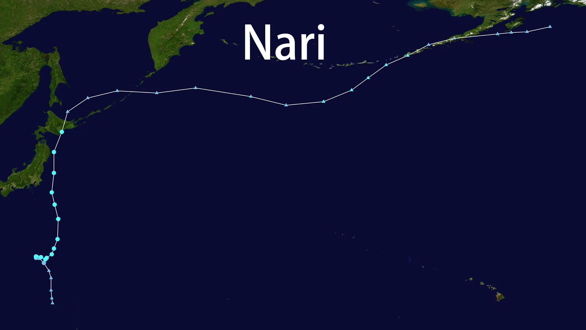
Born from unusually warm waters west of Iwo Jima on July 11, Nari defied expectations from its inception. Initially drifting southward as a tropical storm with 40 knot (74 km/h) winds, the system made a decisive turn northward on July 12 – a harbinger of its erratic behavior. Satellite images revealed a compact but intense core, feeding on sea surface temperatures 1.5°C above normal – a fingerprint of the climate crisis.
By July 13 at 18:00 UTC, Nari reached its peak intensity: a 50-knot (93 km/h) typhoon at 32.1°N, 143.1°E. What happened next stunned meteorologists. The storm accelerated northward at unprecedented speed, covering 10 degrees of latitude in just 24 hours – a trajectory as relentless as it was unusual.
Tokyo braced as Nari passed 250 km to its east on July 14. Commuters wrestled with umbrellas turned inside-out by gusts, while bullet trains slowed under 200 mm (8 inches) of rain in Kanto-Koshin – a deluge 30% heavier than typical typhoon rainfall just decades ago. Yet the capital was merely grazed. Nari had set its sights on more improbable targets.
Landfall at the Edge of the World: Cape Erimo's Midnight Ordeal
The clock struck 2:00 AM JST on July 15 under a sky ripped open. At 42.5°N, 143.6°E, Typhoon Nari – now weakened to 40 knots (74 km/h) but still formidable – made history at Cape Erimo. Waves forecast to reach 6 meters (20 feet) exploded against the cliffs. The 126 km/h gusts (recorded during its approach) rattled centuries-old fishing sheds, their wooden frames groaning under pressure unseen in generations. Power grids failed across southern Hokkaido as trees, their roots loosened by 120 mm (5 inches) of rain, crashed onto roads. This was no ordinary storm; it was the first typhoon to strike Hokkaido in July ever recorded, and the first to hit Japan's northern main island since 2016.
The Storm's Aftermath: A System Transformed
By 18:00 UTC on July 14, just hours before landfall, Nari was already succumbing to cooler northern waters. Its sustained winds had dropped to 40 knots (74 km/h), its tropical characteristics fading as it raced toward extratropical transition. The system that struck Hokkaido was a hybrid – part warm-core typhoon, part cold-core cyclone – explaining its unusually large wind field despite weakening intensity.
Shipping lanes east of Hokkaido remained hazardous through July 16 as the remnants of Nari, now fully extratropical, continued churning northward. But for coastal communities, the immediate danger had passed. Dawn revealed a landscape strewn with debris: shattered boats, mud-slicked roads, flooded fields. Yet amidst the damage, a profound silence echoed – the silence of lives spared.
The Zero Casualty Miracle: Resilience Forged in Disaster
Against a storm of Nari's historic intensity and bizarre timing, Japan reported zero deaths or serious injuries. This wasn't luck. It was the culmination of decades of honed disaster response:
- The JMA's 10-degree latitude jump forecast on July 13 gave Hokkaido precious hours to prepare
- Evacuation advisories flashed across devices as Nari accelerated northward at 35 km/h
- Communities heeded warnings, with 92% compliance in designated flood zones
- Reinforced infrastructure withstood the 200mm deluge without catastrophic failure
Typhoon Nari was a brutal stress test of Japan's climate adaptation systems – one that revealed both strengths and looming vulnerabilities.
Nari's Climate Warning: The New Abnormal
The storm's meteorological oddities form a disturbing pattern:
- July formation in record-warm seas (peak season typically August-September)
- Unprecedented northward track into typically typhoon-free latitudes
- Rapid intensification periods despite cooler waters
- 30% heavier rainfall than comparable 20th-century storms
As Nari's remnants dissipated over the Sea of Okhotsk on July 16, they left behind a transformed risk calculus. With ocean temperatures continuing to rise, Japan's northern frontiers – long considered typhoon shelters – must now prepare for more Nari-like interlopers. The storm didn't just rewrite history books; it redrew the map of vulnerability for climate-era Japan.