
Tracking Tropical Storm 01S: The Unusual Pioneer of the Southern Hemisphere Cyclone Season
While Typhoon Wipha dominates headlines in the Northern Hemisphere, a quieter meteorological story unfolds south of the equator. Tropical Storm 01S, the inaugural system of the 2025-2026 Southern Hemisphere tropical cyclone season, emerged under rare July conditions over the remote southwestern Indian Ocean. This Tropical Storm 01S represents a climatological curiosity rather than an imminent threat.
The Genesis of an Off-Season Anomaly
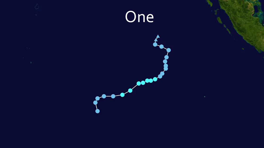
Tropical Storm 01S first materialized on July 16, 2025, near coordinates 9.8°S 89.8°E. Its formation was notably early and unexpected for July, a month typically marking the very beginning of the Southern Hemisphere cyclone season rather than peak activity. Atmospheric analysis points to the passage of a Kelvin wave, which created favorable upper-level divergence over the equatorial Indian Ocean, as a key contributing factor. Meteorologists and weather enthusiasts on platforms like X (notably @WillWeatherRVA, @Sausius_wx, @frontierfcst, and @VortixWx) quickly identified and documented this Tropical Storm 01S as the season's first significant system, highlighting its unusual timing.
Current Status and Track: A Remote Journey West
As of the latest update on July 18, 2025, at 2:00 AM China Standard Time (July 17, 18:00 UTC):
- Position: 10.3°S, 87.6°E
- Movement: Westward at 6 mph (5 knots)
- Intensity: Maximum sustained winds of 40 mph (35 knots), with gusts to 45 mph. Minimum central pressure data remains unavailable.
- Classification: Moderate Tropical Storm
- Location Context: Approximately 559 miles from the Cocos (Keeling) Islands and over 982 nautical miles east of Diego Garcia.
This Tropical Storm 01S has maintained a consistent westward trajectory over the past 48 hours. At the key observation point on July 17, 2025, at 06:00 UTC, Tropical Storm 01S was positioned at 9.9°S, 88.8°E, still moving west at 5 knots with sustained winds of 40 mph (35 knots). The intensity of this Tropical Storm 01S has remained relatively stable but weak, firmly below the 74 mph (64 knot) threshold required for classification as a hurricane or severe tropical cyclone.
Forecast Outlook: A Short-Lived System
All authoritative sources, including the Joint Typhoon Warning Center (JTWC), HurricaneZone, and Cyclocane, concur on the future of Tropical Storm 01S. The system is forecast to maintain its current weak tropical storm intensity for a brief period before succumbing to increasingly hostile environmental conditions.
Two primary factors spell its demise:
- Increasing Wind Shear: Disruptive vertical wind shear is expected to tear apart the storm's structure.
- Cooler Sea Surface Temperatures: As Tropical Storm 01S moves further west, it will encounter ocean waters lacking the necessary thermal energy to sustain it.
Dissipation over the open waters of the southwestern Indian Ocean is anticipated within the next few days. This Tropical Storm 01S is not forecast to make any significant intensification.
Impact Assessment: Minimal Threat
The primary significance of Tropical Storm 01S lies in its climatological rarity as a July formation. In terms of tangible impacts:
- Land Threat: None. Tropical Storm 01S remains exceptionally distant from any populated landmasses. The closest significant territory, Diego Garcia, lies well outside the storm's forecast track and effective range.
- Marine Threat: Impacts are limited to a relatively small area of open ocean within the storm's immediate vicinity, potentially affecting shipping lanes with increased winds and wave heights. No coastal warnings or watches are in effect, nor are any anticipated for this Tropical Storm 01S.
Conclusion: A Fleeting Footnote
Tropical Storm 01S serves as the official, albeit quiet, start to the Southern Hemisphere's 2025-2026 tropical cyclone season. Its formation in mid-July was noteworthy for its earliness, but its trajectory over remote ocean areas and imminent dissipation due to unfavorable atmospheric conditions mean it will pass without significant consequence. The story of this Tropical Storm 01S is one of meteorological interest rather than disaster. Monitoring continues via the Joint Typhoon Warning Center (JTWC) and other specialized agencies like HurricaneZone and Cyclocane, but this particular Tropical Storm 01S is expected to fade from advisories soon.