

The Remarkable Story of Typhoon Nongfa: A Meteorological Phenomenon
Typhoon Nongfa emerged as one of the most fascinating meteorological events of the 2025 Pacific typhoon season, defying conventional expectations with its unique characteristics. This tropical cyclone, despite its remarkably short lifespan of less than 48 hours, managed to create significant impacts across multiple regions, demonstrating how even brief weather systems can leave lasting impressions on affected communities.
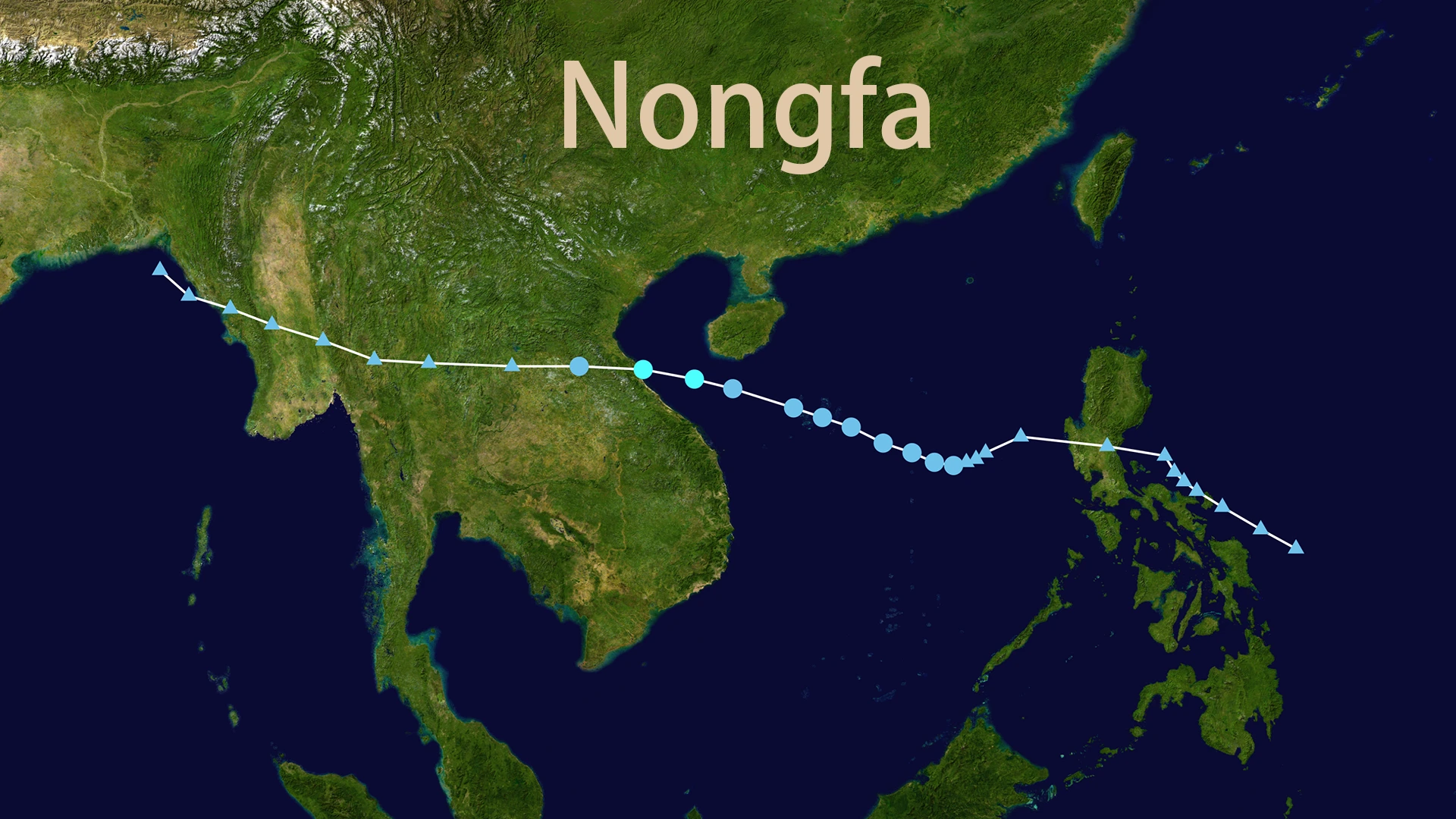
The story of Typhoon Nongfa begins in the South China Sea, where what initially appeared as a routine tropical depression rapidly intensified into a named storm system. What makes Nongfa particularly noteworthy is not its intensity—it never exceeded tropical storm strength—but rather its asymmetric structure and the unexpected reach of its influence. The typhoon's outer rain bands extended far beyond its core, bringing substantial precipitation to China's southern provinces while the center made landfall in Vietnam.
The Rapid Genesis and Evolution of Typhoon Nongfa
Typhoon Nongfa's formation story reads like a meteorological thriller, with the system developing at an unusually rapid pace that caught many forecasters by surprise. On the morning of August 30, 2025, what had been a disorganized area of low pressure in the South China Sea suddenly organized itself into a tropical storm, earning the name Nongfa from the China Meteorological Administration.
The name "Nongfa" itself carries cultural significance, originating from Laos where it means "blue lake" or "blue water." This marked the first time this particular name had been used in the Western Pacific typhoon naming system, adding a unique historical footnote to the storm's legacy. The rapid intensification process that transformed a weak tropical depression into Typhoon Nongfa occurred over just a few hours, showcasing the unpredictable nature of tropical cyclone development.
What made Typhoon Nongfa's development particularly fascinating was its asymmetric structure from the very beginning. Unlike the classic, well-organized tropical cyclones that develop uniform circular wind fields, Nongfa exhibited a distinctly lopsided appearance on satellite imagery. The storm's primary convection and strongest winds were concentrated on its southern and eastern flanks, while the northern and western quadrants remained relatively weak.
This structural peculiarity would prove crucial in determining the storm's impact pattern. While Typhoon Nongfa's core remained relatively compact, its outer rain bands extended hundreds of kilometers to the north and northwest, creating a situation where areas far from the storm's center experienced significant weather impacts.
Typhoon Nongfa's Unconventional Path and Intensity Profile
The movement of Typhoon Nongfa across the South China Sea followed a textbook westward track, but with some notable deviations that kept meteorologists on their toes. The storm maintained a consistent forward speed of 25-30 kilometers per hour, which is relatively fast for tropical cyclones in this region. This rapid movement limited the time available for the storm to intensify significantly, but also meant that its impacts were felt over a broader geographic area in a shorter timeframe.
Typhoon Nongfa's peak intensity occurred on the afternoon of August 30, when the storm achieved maximum sustained winds of 18 meters per second (approximately 40 knots), equivalent to a Category 1 tropical storm on the Saffir-Simpson scale. However, the storm's asymmetric structure meant that these peak winds were not uniformly distributed around the center, creating significant variations in local wind conditions.
The storm's central pressure bottomed out at 995 hectopascals, which is typical for a tropical storm of this intensity. What made Typhoon Nongfa's pressure pattern unusual was the rapid pressure changes that occurred as the storm approached the Vietnamese coast. These fluctuations suggested that the storm was interacting with complex atmospheric conditions, including dry air intrusion and wind shear that would ultimately contribute to its rapid weakening.
The Asymmetric Impact: How Typhoon Nongfa Affected South China
Perhaps the most remarkable aspect of Typhoon Nongfa's story is how its asymmetric structure created significant impacts in regions that were hundreds of kilometers from the storm's center. While the typhoon's core made landfall in Vietnam, its outer rain bands extended northward across the South China Sea, bringing substantial precipitation to China's southern coastal provinces.
The impact of Typhoon Nongfa on Guangdong Province was particularly noteworthy. The storm's outer circulation brought heavy rainfall to the southern coastal areas, with some locations recording precipitation totals of 100-120 millimeters. This rainfall, while not catastrophic, was sufficient to cause localized flooding and disrupt transportation in several coastal cities. The asymmetric nature of the storm meant that while southern Guangdong experienced persistent rainfall, northern areas remained under the influence of a subtropical high-pressure system, experiencing hot and dry conditions.
In Guangxi Zhuang Autonomous Region, the effects of Typhoon Nongfa were felt through dramatic weather changes that caught many residents by surprise. The city of Nanning experienced a remarkable transformation on August 30, with clear skies in the morning giving way to overcast conditions and heavy rainfall during the evening rush hour. This sudden weather shift, caused by the approach of Nongfa's outer rain bands, demonstrated how tropical cyclone impacts can extend far beyond their immediate vicinity.
Hainan Island also felt the influence of Typhoon Nongfa, despite being located well to the east of the storm's track. The island's western and southern coastal areas experienced moderate to heavy rainfall, accompanied by gusty winds that reached 7-9 on the Beaufort scale in some locations. The Haikou Meteorological Observatory issued a blue typhoon warning, advising residents to take precautions and recommending that vessels return to port to avoid the storm's effects.
Typhoon Nongfa's Landfall in Vietnam: A Test of Regional Preparedness
The direct impact of Typhoon Nongfa occurred when the storm made landfall along the central Vietnamese coast on the evening of August 30, 2025. The landfall location, near the border between Quang Tri and Ha Tinh provinces, was consistent with earlier forecasts, allowing Vietnamese authorities to implement their emergency response protocols effectively.
The Vietnamese government's response to Typhoon Nongfa demonstrated the country's sophisticated disaster management capabilities. On August 30, Deputy Prime Minister Tran Hong Ha signed Government Decision No. 153 (153/CĐ-TTg), which activated comprehensive emergency response measures across all relevant ministries and local authorities. This high-level directive, issued even for a relatively weak tropical cyclone, reflected Vietnam's proactive approach to disaster preparedness.
The government's response included the deployment of military and police forces for potential rescue operations, the pre-emptive evacuation of residents from high-risk areas, and the establishment of emergency supply distribution networks. This comprehensive approach, while perhaps appearing excessive for a tropical storm, represents Vietnam's "better safe than sorry" philosophy in disaster management.
The Meteorological Complexity Behind Typhoon Nongfa's Behavior
Understanding why Typhoon Nongfa behaved the way it did requires delving into the complex atmospheric dynamics that governed its development and movement. The storm's rapid formation was likely influenced by several factors, including warm sea surface temperatures in the South China Sea and a favorable upper-level wind pattern that allowed for efficient heat transfer from the ocean to the atmosphere.
The asymmetric structure of Typhoon Nongfa, which proved so crucial to its impact pattern, developed due to several interacting factors. Wind shear from the southwest created an environment where the storm's northern and western quadrants were constantly being disrupted, while the southern and eastern sides remained relatively protected. This created the characteristic lopsided appearance that would define the storm's impact distribution.
Additionally, the presence of dry air in the atmosphere surrounding Typhoon Nongfa contributed to its asymmetric development. This dry air intrusion, common in the South China Sea during the late summer months, prevented the storm from developing the uniform cloud structure typically associated with well-organized tropical cyclones. Instead, it created a situation where the storm's moisture was concentrated in specific quadrants, leading to the uneven rainfall distribution that characterized its impact.
Emergency Response and Coordination: Lessons from Typhoon Nongfa
The response to Typhoon Nongfa demonstrated the effectiveness of China's multi-layered emergency management system. On August 30, the China Meteorological Administration activated a Level IV emergency response for major meteorological disasters (typhoon), which triggered a coordinated response across multiple government agencies and local authorities.
The emergency response system's effectiveness was evident in how quickly warnings and advisories were disseminated to the public. Meteorological stations in affected provinces issued timely alerts, while local governments implemented their emergency protocols with remarkable efficiency. This rapid response capability, developed through years of experience with tropical cyclone threats, proved crucial in minimizing potential impacts.
The coordination between different government departments was particularly noteworthy. While meteorological agencies focused on monitoring and forecasting Typhoon Nongfa's development, transportation authorities prepared for potential disruptions, and emergency services positioned resources for rapid response. This integrated approach ensured that all aspects of the storm's potential impacts were addressed systematically.
The Broader Implications of Typhoon Nongfa's Unusual Characteristics
Typhoon Nongfa's story extends beyond its immediate meteorological impacts, offering valuable insights into the complex nature of tropical cyclone behavior and the challenges of predicting their effects. The storm's asymmetric structure and the resulting uneven distribution of impacts highlight the importance of looking beyond simple intensity classifications when assessing tropical cyclone threats.
The rapid development and dissipation of Typhoon Nongfa also underscores the challenges faced by forecasters in providing timely warnings for fast-evolving weather systems. While modern numerical weather prediction models are increasingly sophisticated, they still struggle with the rapid intensification and structural changes that characterized this storm's lifecycle.
Furthermore, Typhoon Nongfa's impact pattern demonstrates how tropical cyclone effects can extend far beyond their immediate vicinity, challenging traditional approaches to risk assessment and emergency planning. The storm's ability to bring significant rainfall to regions hundreds of kilometers from its center suggests that emergency managers need to consider broader geographic areas when preparing for tropical cyclone impacts.
Scientific Significance and Research Implications
From a scientific perspective, Typhoon Nongfa represents an excellent case study for researchers studying tropical cyclone structure and impact patterns. The storm's asymmetric development provides valuable data for improving our understanding of how environmental factors influence tropical cyclone organization and intensity.
The storm's rapid lifecycle also offers insights into the processes that govern tropical cyclone formation and dissipation in the South China Sea. This region, with its complex atmospheric and oceanic conditions, presents unique challenges for tropical cyclone forecasting, and Typhoon Nongfa's behavior adds to our understanding of these challenges.
Additionally, the storm's impact pattern provides valuable information for improving risk assessment models. By understanding how asymmetric tropical cyclones distribute their effects, emergency managers can better prepare for future events and allocate resources more effectively.
Conclusion: The Legacy of Typhoon Nongfa
Typhoon Nongfa may have been brief, but its impact and the lessons learned from it will resonate far beyond its short lifespan. The storm demonstrated that tropical cyclone threats cannot be assessed solely on the basis of intensity or size, but must be evaluated in terms of their complete structure and the environmental conditions that govern their behavior.
The asymmetric nature of Typhoon Nongfa and its ability to affect regions far from its center highlight the importance of comprehensive emergency planning and the need for sophisticated forecasting capabilities. While the storm's direct impacts were relatively minor, its broader influence on weather patterns across South China demonstrated the complex and interconnected nature of tropical cyclone systems.
Perhaps most importantly, Typhoon Nongfa's story illustrates how even relatively weak tropical cyclones can create significant challenges for emergency managers and communities. The storm's rapid development, unusual structure, and extended impact range serve as a reminder that tropical cyclone threats require constant vigilance and sophisticated response capabilities.
As we continue to study and learn from events like Typhoon Nongfa, we improve our ability to predict, prepare for, and respond to future tropical cyclone threats. The lessons learned from this brief but impactful storm will contribute to the ongoing development of more effective warning systems, better emergency response protocols, and improved understanding of tropical cyclone behavior in the South China Sea region.
The story of Typhoon Nongfa serves as a powerful reminder that in meteorology, as in many other fields, appearances can be deceiving. What appeared to be a routine tropical storm turned out to be a complex and fascinating meteorological event that challenged our understanding and provided valuable insights for future forecasting and emergency management efforts.