

The Unfolding of Hurricane Lorena: More Than Just Wind
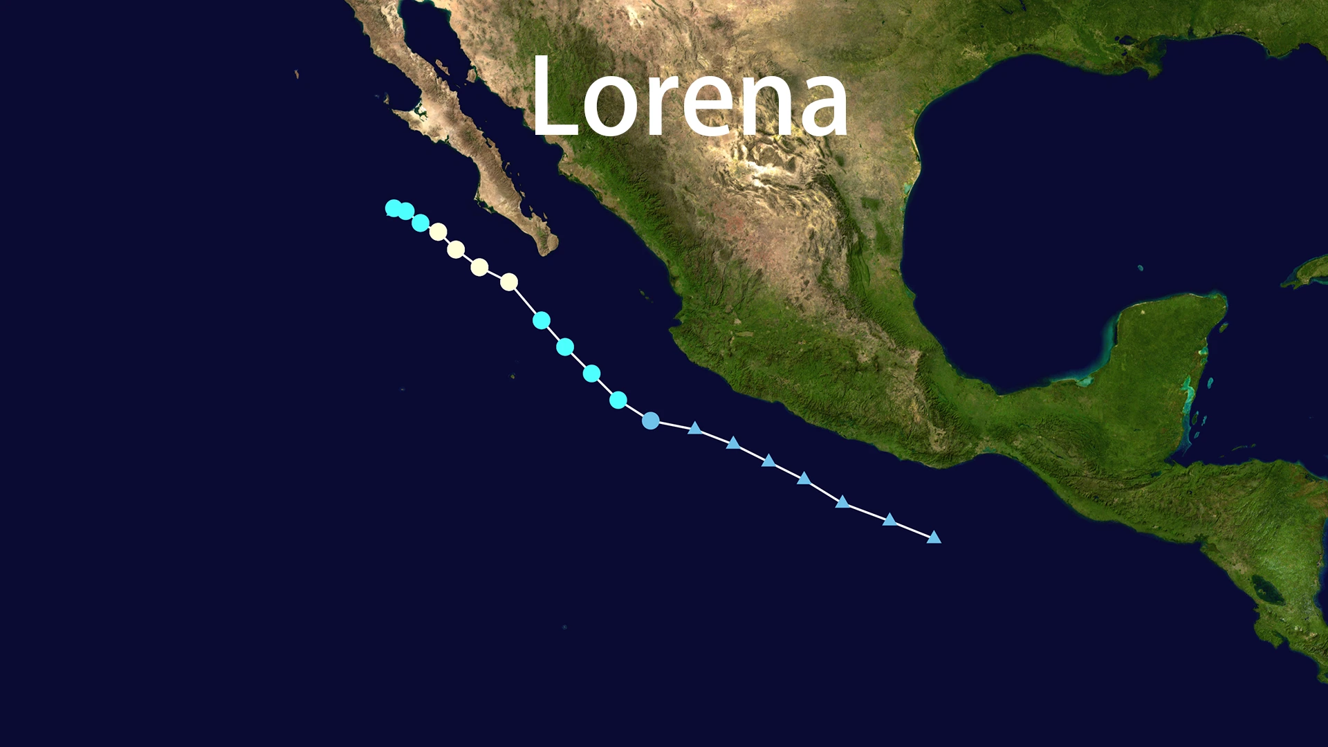
Hurricane Lorena began not with a roar, but as a seemingly modest tropical low-pressure system. Designated as Tropical Depression Twelve-E, it formed over the East Pacific on Monday, September 1, 2025. Within days, this system defied initial modest projections, undergoing rapid intensification. By the pre-dawn hours of Wednesday, September 3, Hurricane Lorena had achieved Category 1 status, boasting maximum sustained winds of 85 mph. Its peak intensity was a notable, though not catastrophic, meteorological event.
However, the true story of Hurricane Lorena was never written in its wind speeds. The narrative quickly shifted as the storm adopted a unique and perilous path. On Thursday, September 4, Hurricane Lorena slowed its forward motion and began tracking parallel to the coastline of the Baja California Peninsula. This parallel trajectory was a critical turning point. As it inched along the coast, its winds rapidly diminished, leading to its downgrade to a tropical storm. But this weakening was a deceptive mirage. The storm's slow, coastal crawl allowed it to act like a massive pump, pulling immense volumes of moisture from the ocean and dumping it relentlessly over land. The primary threat transformed from a wind event into a profound water event, with forecasts warning of isolated rainfall totals reaching a devastating 15 inches.
By Friday, September 5, the entity known as Hurricane Lorena had dissipated into a remnant low-pressure area. The National Hurricane Center issued its final advisory, yet the danger was far from over. Their bulletins continued to emphatically stress the persistent, "life-threatening" risk of flash flooding and landslides. This crucial disconnect—between the storm's official classification and its actual hazard—posed a significant public communication challenge. Hurricane Lorena became a powerful lesson in looking beyond the Saffir-Simpson scale to understand a storm's true character.
Assessing the Impact: Human and Economic Toll
Widespread Devastation in Mexico
The states of Baja California Sur and Sonora, unaccustomed to such prolonged and intense rainfall, bore the brunt of Hurricane Lorena's fury. In La Paz, winds between 75-95 km/h toppled power poles and severed communication lines. Approximately 40% of homes in the city's coastal zones suffered structural damage. The Manuel Márquez de León International Airport was forced to temporarily close as runways flooded, severing a critical economic artery.
Further north in Sonora, cities like Hermosillo and Guaymas experienced widespread flooding. Torrential rains sent walls of water through streets and into homes, with water levels in some areas reaching a staggering 5 feet high. The scene was one of mud, debris, and disrupted lives.
A Triumph of Proactive Preparedness
In the face of this impending disaster, the response from Mexican and U.S. authorities was a textbook example of proactive, coordinated disaster management. Heeding accurate meteorological forecasts, the government of Sonora took the decisive step of canceling school and university classes across all 72 of its municipalities for both September 4 and 5. The U.S. Consulate General in Hermosillo closed its doors as a precautionary measure.
Emergency services sprang into action with remarkable efficiency. The Mexican army was deployed to assist in distributing food, water, and medicine. In a massive logistical effort, over 12,000 residents were preemptively evacuated to temporary shelters set up in schools and community centers. The U.S. Department of State issued a series of alerts, advising citizens to seek shelter and avoid floodwaters. This data-driven, forward-thinking approach undoubtedly saved lives and stands as a key legacy of Hurricane Lorena.
The Economic Aftermath: A Tale of Two Economies
The economic impact of Hurricane Lorena, estimated in the millions of dollars, laid bare the systemic vulnerabilities of the regional economy. The effect was deeply unequal, highlighting a stark contrast between two coexisting economic worlds.
The tourism industry, the luxurious lifeblood of Baja California Sur, was brought to a complete standstill. In the world-renowned resort town of Cabo San Lucas, power outages plunged hotels into darkness. These very hotels, typically bustling with vacationers, were transformed into emergency shelters—a powerful symbol of how economic engines were repurposed for survival. The cost of repairing damage to high-end infrastructure was immense.
Meanwhile, the storm delivered a crushing blow to the region's agricultural and fishing communities. Crops were submerged under relentless rains. Fishermen reported devastating damage to their boats and equipment—losses that, while less monetarily significant than a hotel's repair, represented an immediate and direct threat to the livelihoods of families and entire communities. The story of Hurricane Lorena's economic damage is a story of this duality: high-value asset loss versus profound human-scale livelihood destruction.
Cross-Border Ripple Effects: A Parodoxical Blessing and Curse
Hurricane Lorena did not make landfall in the United States, but its influence stretched far across the border. The storm's remnants funneled a plume of tropical moisture northeastward into the Southwestern U.S., impacting Arizona, New Mexico, and Texas.
This presented a complex atmospheric paradox. For drought-stricken regions, the rains from Hurricane Lorena were a desperately needed replenishment for parched reservoirs and aquifers. Yet, this same life-giving water became a lethal threat. Years of drought had hardened the soil, creating a landscape incapable of absorbing water quickly. The result was rapid runoff, leading to serious flash flooding. Hurricane Lorena thus delivered a critical lesson in climate adaptation: in a warming world, a single weather event can be both a solution to one crisis and the cause of another.
Lessons from the Past, Preparedness for the Future
While significant, the impact of Hurricane Lorena was not unprecedented. Historical context is crucial. The 1976 Hurricane Liza remains the region's deadliest storm, claiming over 435 lives. The 2014 Hurricane Odile holds the title for the most economically destructive. Hurricane Lorena was a severe, but not record-breaking, regional event.
Its true significance lies in its timing and the lessons it imparts. Hurricane Lorena occurred during an "above-normal" 2025 season, following closely behind a powerful Category 5 Hurricane Irene. This pattern suggests not an isolated incident, but a new normal of frequent and intense seasonal activity.
The experience of Hurricane Lorena offers strategic recommendations for the future:
- Invest in Hydrometeorological Forecasting: Prioritizing the communication of water-related risks, not just wind, is essential.
- Enhance Cross-Border Cooperation: The successful U.S.-Mexico coordination during Hurricane Lorena should serve as a model for formalized international disaster protocols.
- Build Diversified Economic Resilience: Recovery plans must support both large-scale industries and the fragile local economies that are most vulnerable.
- Educate on Compound Risks: Public safety campaigns in arid regions must specifically address the paradoxical danger of flash flooding triggered by remnant storms like Hurricane Lorena.
In conclusion, Hurricane Lorena was more than a storm; it was a compelling case study for a new era of extreme weather. Its legacy is one of successful preparedness, exposed vulnerability, and a clear warning that our understanding of risk must evolve as quickly as the climate itself.