
Tropical Storm Peipah: The Moderate Storm That Brought a Major Economy to a Halt
In the grand theater of the 2025 Pacific typhoon season, which featured powerful actors, Tropical Storm Peipah played a role that was brief but profoundly impactful. Its story is not one of record-breaking winds or catastrophic flooding, but a masterclass in how a moderate system, when positioned perfectly, can expose the intricate vulnerabilities of a hyper-developed society. The saga of Peipah is a crucial lesson in looking beyond the category to understand true risk.
The Making of Peipah: A Name with a History
The name Peipah itself carries a story of consequence. It was not on the original list for 2025. Instead, it was selected by the WMO Typhoon Committee to replace the name "Wipha," which was retired after a destructive storm in July of that year. This act of naming is meteorological shorthand for a storm that left a mark severe enough to be immortalized and then retired. From its first designation, Peipah carried the legacy of impactful storms.
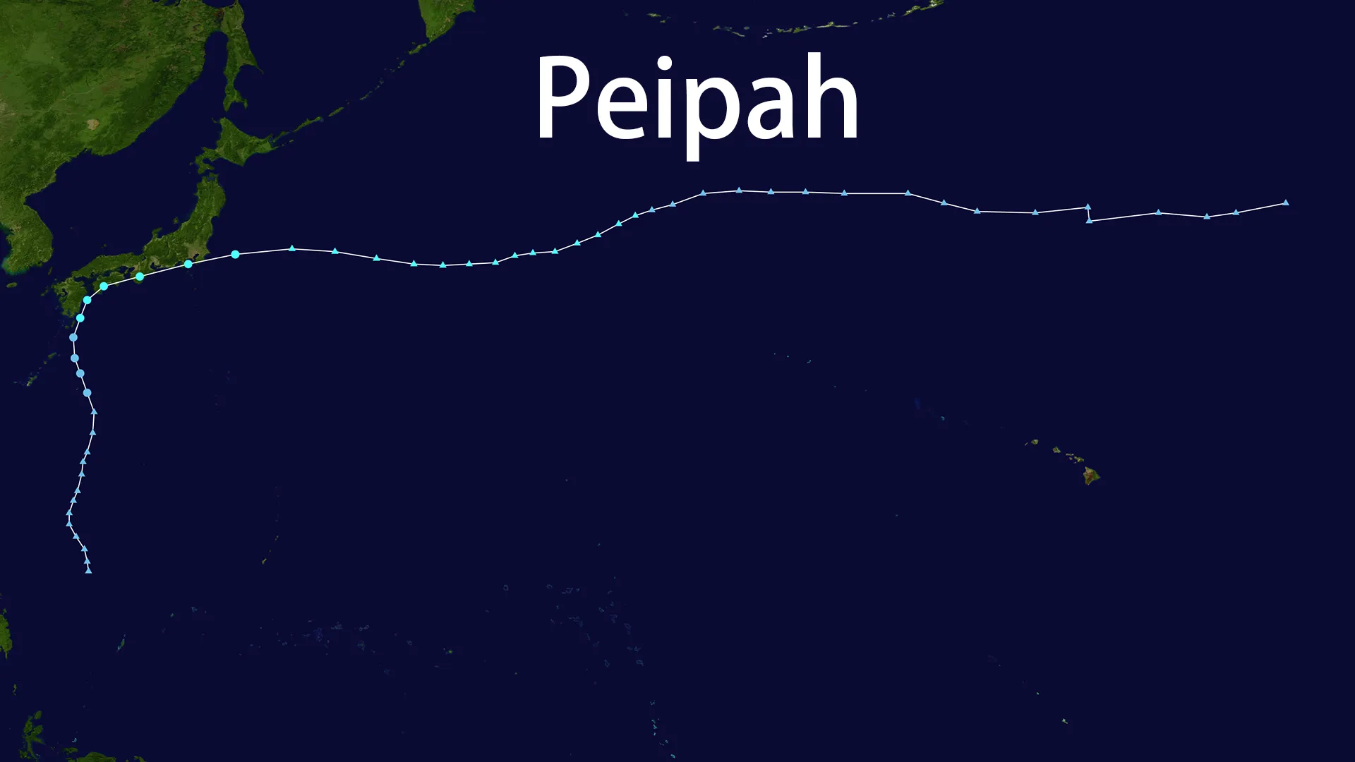
The journey of Tropical Storm Peipah began as a humble disturbance, labeled 95W, near Yap on August 29. Over several days, it meandered northwest, gradually organizing itself. The Joint Typhoon Warning Center (JTWC) and Japan Meteorological Agency (JMA) watched closely, upgrading it to a tropical depression by September 2. Finally, in the early hours of September 4, the JMA gave it the name Peipah, officially designating it as the season's 16th named storm.
A Path of Maximum Disruption
Tropical Storm Peipah never grew into a monstrous typhoon. It peaked with sustained winds of around 60 mph (95 km/h) and a central pressure of 990 hPa. Meteorologically, it was unremarkable. Its true significance lay in its trajectory. Moving north-northeast at a brisk 25-30 km/h, Peipah was guided like an arrow toward the heart of Japan's most densely populated and economically critical region.
On September 5, Tropical Storm Peipah made its dramatic entrance, not once, but twice. It first came ashore in Ehime Prefecture around midnight JST, and then again hours later in Wakayama Prefecture. This double landfall ensured that a wide swath of central Honshu, from the industrial coasts to the sprawling suburbs of greater Tokyo, felt the storm's force. By that evening, Peipah had raced out to sea near Chiba, transitioning into a post-tropical cyclone, but its work was done.
The Real Impact: When the Bullet Train Stops
The legacy of Tropical Storm Peipah is measured not in barometric pressure, but in paralysis. In a nation renowned for its efficiency and resilience, Peipah demonstrated how quickly wind and rain can unravel the threads of daily life.
The storm's most visible impact was on Japan's world-class transportation network. The lifeblood of the country's economy, the Tokaido Shinkansen bullet train service, was suspended for hours due to torrential rain, stranding thousands of commuters and business travelers. In the skies, the chaos was equally profound. Tokyo's Haneda Airport, one of the busiest in the world, was forced to halt all takeoffs and landings for a full hour as Peipah's fury passed overhead. The storm's reach extended into the air itself; a Jetstar Japan flight bound for Fukuoka was struck by lightning, a terrifying reminder of the hazards embedded within the storm.
On the ground, the effects were more personal but no less disruptive. Powerful gusts toppled power poles in Shizuoka, cutting electricity to homes and businesses. In Makinohara City, Shizuoka, fierce winds caused significant structural damage to buildings, resulting in 24 injuries from a single incident. Tragically, an elderly man in Hamamatsu was lost after allegedly falling into a waterway amid the storm's heavy rains. In total, Tropical Storm Peipah was responsible for 30 injuries across the country.
The Deeper Lesson of Peipah
The narrative of Tropical Storm Peipah challenges the conventional wisdom that equates storm strength solely with wind speed. Peipah was a potent reminder of the concept of "compound risk."
- Economic Vulnerability: Japan's advanced economy is a network of precise interdependencies. A halt in the Shinkansen doesn't just delay passengers; it disrupts supply chains, business meetings, and logistics. An airport closure doesn't just cancel vacations; it impacts international commerce and connectivity. The economic losses from Peipah, while not yet fully quantified, stemmed from this widespread interruption.
- Social Vulnerability: Even in a prepared nation, localized events can have severe consequences. Linear rainbands—intense, narrow corridors of heavy precipitation—can trigger flash flooding anywhere. Strong gusts can topple infrastructure in precisely the wrong place, as seen in Makinohara.
The experience of Tropical Storm Peipah proves that for modern, developed nations, the critical question is not just "how strong will the storm be?" but "where will the storm be?" Peipah' path was a worst-case scenario for causing maximum disruption with minimal meteorological intensity.
Peipah in the Context of the 2025 Season
The 2025 season was forecast to be "above-normal," and Tropical Storm Peipah was one of 16 named storms that formed. While it may be overshadowed in history by stronger typhoons, its impact was uniquely instructive. It served as a live-fire drill for how interconnected systems fail and how societies respond. It underscored that in the 21st century, resilience planning must focus as much on protecting complex networks and maintaining continuity as it does on evacuating people from storm surges.
Conclusion: The Storm That Taught Us to Look Deeper
Tropical Storm Peipah will be remembered not for its power, but for its precision. It was a moderate storm that chose a target which amplified its effects a hundredfold. The name Peipah may never be retired, but its lesson should be permanently etched into the playbooks of meteorologists, emergency planners, and policymakers worldwide: true disaster risk is a blend of hazard, exposure, and vulnerability. Sometimes, the greatest lessons come not from the strongest storms, but from the smartest ones.