
Cyclone Garance: A Historic Storm's Path of Destruction in the Indian Ocean
Meteorological Profile and Intensity Evolution
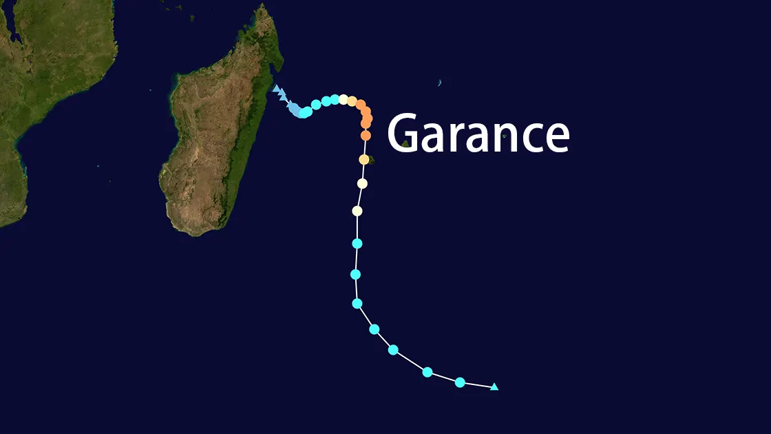
Cyclone Garance emerged as a formidable system in the southwestern Indian Ocean, peaking as a Category 3-equivalent tropical cyclone with sustained winds of 120 mph (193 km/h) and gusts exceeding 230 km/h (143 mph). Classified by Météo-France as Réunion's strongest storm since Cyclone Firinga (1989), Garance underwent extratropical transition on March 1, 2025, driven by strong vertical wind shear (35+ knots) and cooling sea surface temperatures (24–25°C). The Joint Typhoon Warning Center (JTWC) noted its rapid southeastward movement at 22 knots before dissipation.
Landfall and Immediate Impacts
Cyclone Garance made landfall on Réunion's northern coast on February 28, 2025, with:
Wind gusts: 166 km/h (103 mph) at landfall, peaking at 230 km/h (143 mph) in Piton Sainte-Rose.
Rainfall: Over 200 mm (7.8 inches) in 24 hours, triggering flash floods and mudslides.
Wave heights: 20-foot swells offshore.
Catastrophic Impacts on Réunion Island
Human Toll and Infrastructure Collapse
Cyclone Garance claimed four lives and caused widespread devastation:
A man crushed by a fallen tree in Saint-Denis (March 1).
Two women and a man killed by floods, mudslides, and electrical fires (February 28).
Critical infrastructure suffered severe damage:
Power outages: 160,000+ households without electricity.
Water shortages: 310,000 residents lost access to drinking water.
Transportation: Roads flooded, bridges collapsed, and the international airport closed until March 1.
Resident Testimonies and Local Trauma
Vincent Clain, a Sainte-Marie resident, described Garance as "the first time I've been afraid" during a cyclone, citing uprooted trees and structural damage. Aline Etheve from Sainte-Suzanne reported near-collapse conditions in her home.
Regional and Global Implications
Disruption Across the Indian Ocean
Mauritius: Preemptive airport closures disrupted tourism.
Mayotte: Heightened alertness due to Garance's proximity, following Cyclone Chido's devastation in 2024.
Speculative Geophysical Link
While unverified, energy antipodes of Cyclone Garance coincided with a M 3.9 earthquake near Los Angeles, California—a rare phenomenon warranting further scientific study.
Government Response and Recovery Challenges
Criticism and Crisis Management
French Prime Minister François Bayrou urged compliance with safety protocols, deploying 200 emergency workers from Mayotte and mainland France. However, criticisms echoed Cyclone Chido's aftermath, where President Macron faced backlash for delayed aid.
Long-Term Recovery Efforts
Patrice Latron, Réunion's central government representative, emphasized "a lot of work" ahead due to:
Environmental risks: Lingering landslide threats from saturated soils.
Utility restoration: Weeks-long repairs to power grids and water systems.
Historical Context and Climate Connections
Cyclone Garance surpassed Cyclone Belal (January 2024) in intensity, reflecting trends in Indian Ocean tropical systems. Studies link warming sea surfaces (0.5–1°C above pre-industrial levels) to rapid intensification patterns observed in Garance.
Conclusion
Cyclone Garance underscores the escalating threats posed by climate-amplified cyclones. With winds rivaling historic storms and cascading regional impacts, Réunion's recovery highlights the urgent need for resilient infrastructure and proactive governance. As Garance fades, its legacy—a blend of human tragedy and geophysical intrigue—serves as a stark warning for vulnerable Indian Ocean territories.