

Tropical Cyclone Seru: Path, Intensity, and Impact Analysis
Overview of Tropical Cyclone Seru
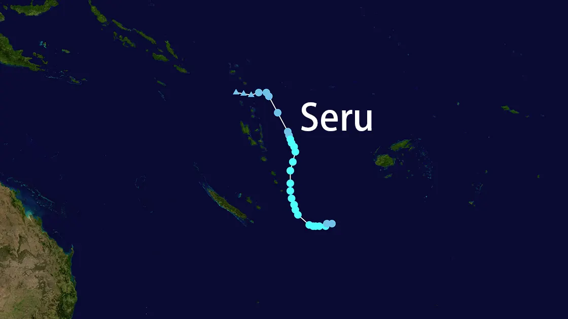
Tropical Cyclone Seru (TC Seru), designated as 21P, formed in late February 2025 over the South Pacific. Initially classified as a Category 2 storm, Seru brought destructive winds, heavy rainfall, and coastal flooding to Vanuatu and Fiji before weakening due to unfavorable atmospheric conditions.
Key Timeline and Intensity
Development and Peak Strength
- 25–26 February 2025:
- Rapid intensification to Category 2 (C2) with sustained winds of 100 km/h and a central pressure of 980–991 mb.
- 27 February:
- Downgraded to Category 1 (C1) as wind speeds decreased to 85–95 km/h.
- 28 February:
- Further weakened to a subtropical system with winds of 55 km/h and a pressure of 996–1000 mb.
Dissipation
By 1 March 2025, Seru was declared "too weak" by meteorological agencies, with its low-level circulation center fully exposed due to high vertical wind shear (20–25 kt). The storm dissipated into the South Pacific Convergence Zone (SPCZ).
Impacted Regions
Vanuatu
- Tafea Province:
- Red Alert issued for destructive winds (110–160 km/h) and coastal flooding.
- Heavy rainfall caused flash floods in low-lying areas.
- Shefa Province:
- Yellow alert lifted as Seru moved east-southeast at 21 km/h.
Fiji
- Lau Group:
- Schools closed due to infrastructure damage from prior Cyclone Rae.
- Heavy rain warnings issued nationwide.
- Labasa:
- Drainage systems upgraded to mitigate urban flooding risks.
Meteorological Analysis
Factors Behind Weakening
- Vertical Wind Shear (VWS): Increased to 20–25 kt, decoupling convection from the circulation center.
- Cool Sea Surface Temperatures (SST): Dropped to 27–28°C, reducing energy supply.
- Dry Air Intrusion: Disrupted storm structure from the western periphery.
Satellite and Sensor Data
- Himawari-9: Tracked Seru’s exposed low-level circulation.
- Advanced Dvorak Technique: Estimated peak intensity at CI 2.9 (43 kt winds).
Response and Recovery
- Vanuatu Meteorology and Geo-hazards Department: Issued marine warnings for rough seas and gale-force winds.
- Fiji Meteorological Service: Coordinated with disaster management agencies to restore roads and crossings.
- Fiji Police Force: Prioritized safety during drug destruction operations amid cyclone alerts.
Conclusion
Tropical Cyclone Seru exemplified the challenges of forecasting hybrid subtropical systems. While its peak intensity threatened Vanuatu’s southern islands, rapid weakening spared Fiji from catastrophic damage. Authorities emphasized preparedness for overlapping disasters, including floods and infrastructure strain. For real-time updates, follow the Joint Typhoon Warning Center (JTWC) and regional meteorological services.