
The Relentless March of Typhoon Co-may
Beneath the oppressive July heat of 2025, the Pacific stirred with gathering fury. What began as a whisper—a weak low-pressure system northeast of Ilocos Norte, Philippines on July 23rd—exploded into Typhoon Co-may within hours. Named by the Japan Meteorological Agency (JMA) and dubbed "Emong" by Philippine authorities, Co-may embarked on a devastating 10-day odyssey. Its serpentine path would scar landscapes from Luzon to Shanghai, leaving communities submerged and economies shattered in its wake.
Birth of a Tempest
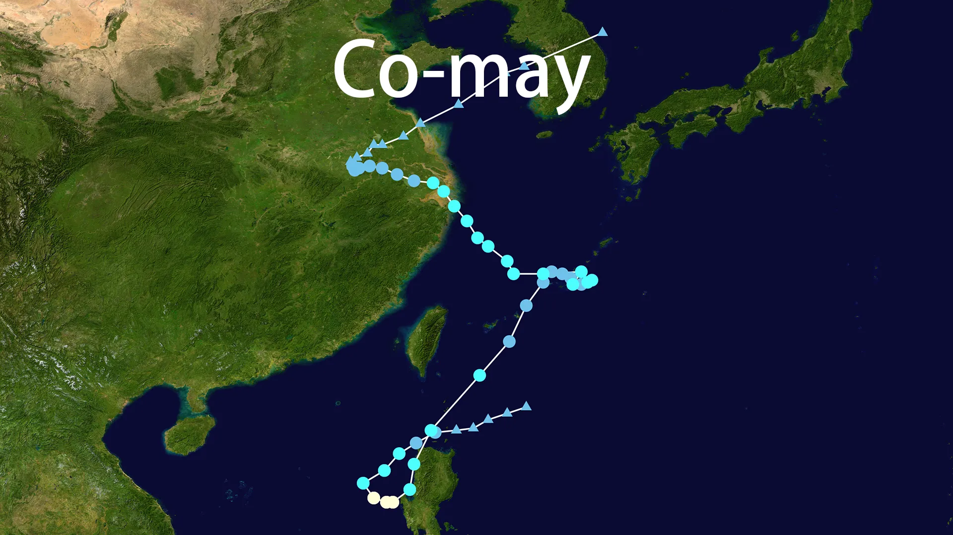
The genesis of Typhoon Co-may unfolded with ominous deliberation. Convection swirled over the Babuyan Islands on July 23rd, fed by bath-warm seas and unstable air. By 20:00 local time, China's Central Meteorological Observatory confirmed its intensification into a tropical storm. The name Co-may—Vietnam's contribution meaning "Bermuda grass," a resilient plant carpeting Southeast Asia—carried cruel irony as the storm prepared to tear through those very lands. This poetic designation replaced the retired "Lekima," entering meteorological history as satellite imagery captured its tightening spiral. When PAGASA assigned it the local name "Emong," Typhoon Co-may had already declared its intentions through deepening cloud tops and falling barometers.
The Storm's Twisted Odyssey
Typhoon Co-may defied predictions at every turn. By July 24th, it achieved Category 1 strength (120 km/h winds, 975 hPa), slamming into Agno, Pangasinan at 22:40 PHT—the fiercest strike there since 2009. Dawn on July 25th found Typhoon Co-may making landfall again in Candon, Ilocos Sur, its rain bands scouring mountainsides. Then came the meteorological dance: caught in Typhoon Francisco's Fujiwhara embrace, Co-may looped northeast before resurrecting near Okinawa on July 27th. Reinvigorated, Typhoon Co-may drove westward, its core slamming into Zhujiajian Island, Zhoushan on July 30th. Still relentless, Typhoon Co-may delivered a final blow at dusk to Shanghai's Fengxian District on July 31st, neon signs flickering above flooded streets as emergency boats plied avenues-turned-rivers.
Scars Across Nations
Where Typhoon Co-may trod, it carved landscapes of loss. In Ilocos' villages, 25 lives vanished under landslides triggered by the typhoon's torrents. Over 49,000 Filipinos battled Co-may's floods, with 278,000 evacuated—Malabon residents paddling makeshift rafts through submerged homes. Days later in Beijing, commuters waded through waist-deep floods that claimed 30 lives, exposing even the capital's vulnerability to Typhoon Co-may's aquatic onslaught. Shanghai's reckoning was apocalyptic: 283,000 evacuated as Co-may's storm surge overwhelmed seawalls. At Pudong and Hongqiao airports, 640 flights vanished from boards. Coastal Yangshan Port endured 102 km/h winds while highways became treacherous streams under enforced 60 km/h limits. When Typhoon Co-may finally dissipated on August 3rd, it left a grim ledger: 55 lives, $73 million in ruins, and half a million displaced across its path.
Anatomy of Resilience
Typhoon Co-may's endurance was a masterclass in atmospheric violence. Its 10-day rampage was fueled by 30°C+ Pacific waters and weak wind shear—conditions that nursed it through multiple landfalls. The Fujiwhara tango with Francisco didn't just alter Typhoon Co-may's path; it extended its lifespan, pulling the storm into a resource-rich northeasterly loop. Abundant monsoon moisture transformed Typhoon Co-may into a "triple threat" alongside Typhoons Krosa and Francisco in late July's rare convergence. Even when declared dissipated on July 26th, Typhoon Co-may resurrected over the Ryukyus, its asymmetric structure reassembling like a phantom. This chameleon-like resilience made Typhoon Co-may a case study in how warming oceans breed unkillable storms.
In Pangasinan, fishermen now rebuild bamboo homes above new flood lines. Shanghai's engineers draft redesigned seawalls, studying Typhoon Co-may's surge patterns. The name Co-may—once symbolizing humble grass—now measures humanity's stubborn regrowth after the tempest. As climate patterns shift, this storm's legacy endures not just in damage reports, but in the reinforced foundations of communities that weathered Typhoon Co-may's wrath and chose to rebuild.