

The Brief Fury of Hurricane Gil: A Pacific Spectacle That Never Made Landfall
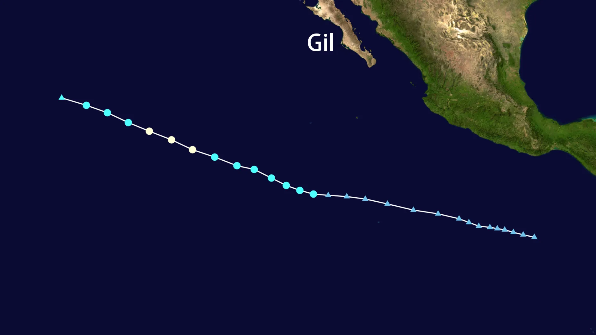
The vast expanse of the Eastern Pacific birthed a fleeting tempest in late July 2025. Hurricane Gil emerged not with a roar heralding destruction, but as a swift, intense dance over open waters, captivating forecasters before fading back into the ocean's embrace. Born as a tropical depression on July 28th, far southwest of the Mexican coast, the system initially churned with modest ambition.
Warm Pacific waters, however, offered fuel. By July 31st, the depression had gathered its strength, earning the name Tropical Storm Gil. Satellite imagery revealed a more organized circulation, its cloud bands tightening as it began a steady march west-northwestward. Social media channels like X buzzed with early predictions from meteorologists like @jayhobgood, suggesting Hurricane Gil was on a path to intensify. The National Hurricane Center (@NHC_Pacific) diligently tracked its every move.
True to the forecasts, Hurricane Gil reached its zenith on August 1st. Beneath a complex atmospheric canvas, it intensified into a Category 1 hurricane. Its maximum sustained winds peaked at 75 mph (120 km/h), swirling around a central pressure of 991 mb. At this moment of peak intensity, Hurricane Gil was a formidable force, yet profoundly isolated – a speck in the immense ocean roughly 1080 miles southwest of Baja California. As noted by observers like @MitchH1917, Hurricane Gil became the season's fifth hurricane, a statistic reflecting activity but not necessarily lasting power. Indeed, discussions highlighted by accounts such as @BackpirchCrew pointed out the 2025 Pacific season's significantly below-normal Accumulated Cyclone Energy (ACE), running 37% below average – a context framing Hurricane Gil's inherent transience.
The journey of Hurricane Gil was one destined solely for the sea. Maintaining a consistent track west-northwest at 18-20 mph (30-32 km/h), its core remained hundreds of miles from any coastline. It was the quintessential "fish storm," a spectacle for satellites and ocean buoys, but never a threat to land. By August 2nd, the environment grew hostile. Cooler sea surface temperatures starved Hurricane Gil of its primary energy source, while dry air infiltrated its circulation like a poison. The once-defined eye vanished, and the winds began to falter.
The end came swiftly. Downgraded to a tropical storm early on August 3rd, Hurricane Gil completed its transition to a post-tropical cyclone by late morning. The National Hurricane Center issued its final advisory at 11:00 AM PDT on August 3rd. At that moment, the remnants of Hurricane Gil were located near 20.6°N, 135.7°W – still a vast distance from both Baja California and Hawaii. Maximum winds had dropped to 50 mph (85 km/h), the pressure had risen to 1003 mb, and the system was unraveling rapidly. Predictions accurately foretold its complete dissipation around August 6th.
| Date/Time (PDT) | Status | Max Winds (mph) | Min Pressure (mb) | Location |
|---|---|---|---|---|
| 2025-07-31 | Tropical Storm | 45 | - | Far SW of Mexican Coast |
| 2025-08-01 (Peak) | Hurricane (Cat 1) | 75 | 991 | ~1080 mi SW of Baja California |
| 2025-08-03 11:00 AM | Post-Tropical Cyclone | 50 | 1003 | 20.6°N, 135.7°W |
The legacy of Hurricane Gil is one of meteorological interest, not human impact. No land experienced its winds or rains. No damage was reported. No lives were lost. NHC records, Wikipedia entries, and the fading real-time chatter on social media all tell the same story: a potent but mercifully short-lived system that lived and died over the open Pacific. Its brief existence contributed to a season characterized, so far, by below-normal overall energy output. By August 6th, 2025, the name Gil was already receding into the archives, a reminder of the Pacific's capacity to generate fury that, sometimes, spares the shore.