
Tropical Storm Henriette (2025): A Historically Significant Pacific Cyclone
Tropical Storm Henriette carved an unexpected path through the Pacific in August 2025, transforming from a modest disturbance into a hurricane in a region where such intensity is exceptionally rare. As the eighth named storm of the active 2025 Pacific hurricane season, Henriette defied climatological expectations while remaining harmlessly over open ocean. This analysis details the journey and scientific significance of Henriette, a storm that challenged forecasting paradigms without threatening land.
Genesis and Track
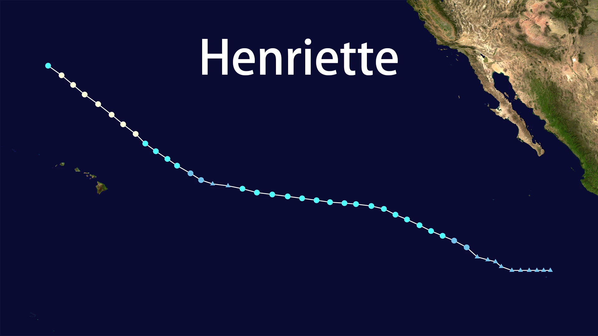
Henriette emerged from a tropical disturbance roughly 895 miles southwest of Baja California on August 4, 2025. Designated Tropical Depression Ten-E by the National Hurricane Center (NHC), the system intensified into Tropical Storm Henriette within 12 hours, with sustained winds reaching 45 mph.
The storm maintained a consistent west-northwest trajectory at 12-18 mph, steered by a subtropical ridge. On August 8, Henriette crossed 140°W longitude into the Central Pacific Hurricane Center's (CPHC) jurisdiction. Its closest approach to Hawaii occurred on August 10-11:
- 445 miles northeast of Hilo
- 455 miles northeast of Honolulu
Henriette's predictable path stood in stark contrast to its erratic intensity, showcasing modern meteorology's proficiency in track forecasting versus ongoing intensity prediction challenges.
Unprecedented Intensification
Henriette's most remarkable feat occurred between August 9–10. Despite marginal sea surface temperatures (SSTs) of 26.1°C (79°F) – barely above the hurricane development threshold – the storm underwent rapid intensification (RI). A negatively tilted upper-level trough created ideal outflow conditions, enabling Henriette to defy expectations:
| Date (2025) | Status | Max Winds (mph) | Key Development |
|---|---|---|---|
| August 10 | Hurricane (Cat 1) | 80 | Eye formation confirmed |
| August 11 | Peak Intensity | 85 | Hurricane winds extend 15 miles |
This transformation marked Henriette as only the 13th system since 1950 to achieve hurricane status north of Hawaii – a region typically hostile to cyclones due to cooler waters and higher wind shear.
Rapid Demise and Post-Tropical Transition
Henriette's hurricane status proved fleeting. By August 12, three destructive forces triggered its collapse:
- Cooling SSTs (dropping below 25°C)
- Increasing vertical wind shear (>25 knots)
- Mid-level dry air intrusion
Satellite imagery on August 13 revealed a fully exposed low-level circulation with fragmented convection. CPHC Advisory #36 at 03:00 UTC declared Henriette post-tropical near 35.3°N, 164.3°W, with residual 50 mph winds. The remnant low dissipated over the open North Pacific by August 15.
Remote Impacts on Hawaii
Though Henriette remained 400+ miles offshore, it generated significant indirect effects:
Oceanic: 10–15 foot swells battered north-facing shores (August 11–12), creating hazardous rip currents.
Atmospheric:
- Trade wind disruption led to "light and variable" winds
- Moisture influx raised dew points above 70°F (21°C)
- Enhanced afternoon showers over leeward areas
Ecological: Moisture partially offset ongoing "abnormally dry to extreme drought" conditions, though wildfire risks persisted.
Scientific Legacy
Henriette's meteorological significance extends beyond its lifespan:
Intensity Forecasting Gap
The underpredicted RI event highlighted critical limitations in anticipating rapid organization despite accurate track modeling.
Climate Anomaly Indicator
Henriette thrived where few cyclones intensify due to August 2025's abnormal 79°F SSTs – 1–2°C above historical averages. This positions Henriette as a benchmark for studying marine heatwaves' impact on tropical cyclogenesis.
Effective Risk Communication
CPHC and NHC consistently conveyed Henriette's "no land threat" message, demonstrating successful public risk management amid forecasting uncertainties.
Conclusion
Tropical Storm Henriette (2025) exemplified nature's capacity to defy climatological norms. Its hurricane-strength intensification north of Hawaii – fueled by transient oceanic warmth – provides invaluable data on environmental thresholds for cyclogenesis. While Henriette spared coastal communities, its legacy persists through improved understanding of RI mechanics and the critical role of ocean thermodynamics in storm evolution. As climate patterns evolve, Henriette's journey offers essential insights for anticipating future Pacific cyclone behavior.