
Tracking Tropical Storm Mario: A Mini Storm with Massive Impact
In mid-September 2025, Tropical Storm Mario carved a unique path through the Eastern Pacific, delivering a powerful lesson to meteorologists and coastal communities alike. This seemingly minor weather system, the thirteenth named storm of the season, demonstrated that a storm's official category and size can be profoundly misleading. The story of Tropical Storm Mario is not one of catastrophic winds, but of unexpected resilience, tragic flooding, and a far-reaching moisture plume that disrupted weather patterns hundreds of miles from its center.
The Unpredictable Life Cycle of Tropical Storm Mario
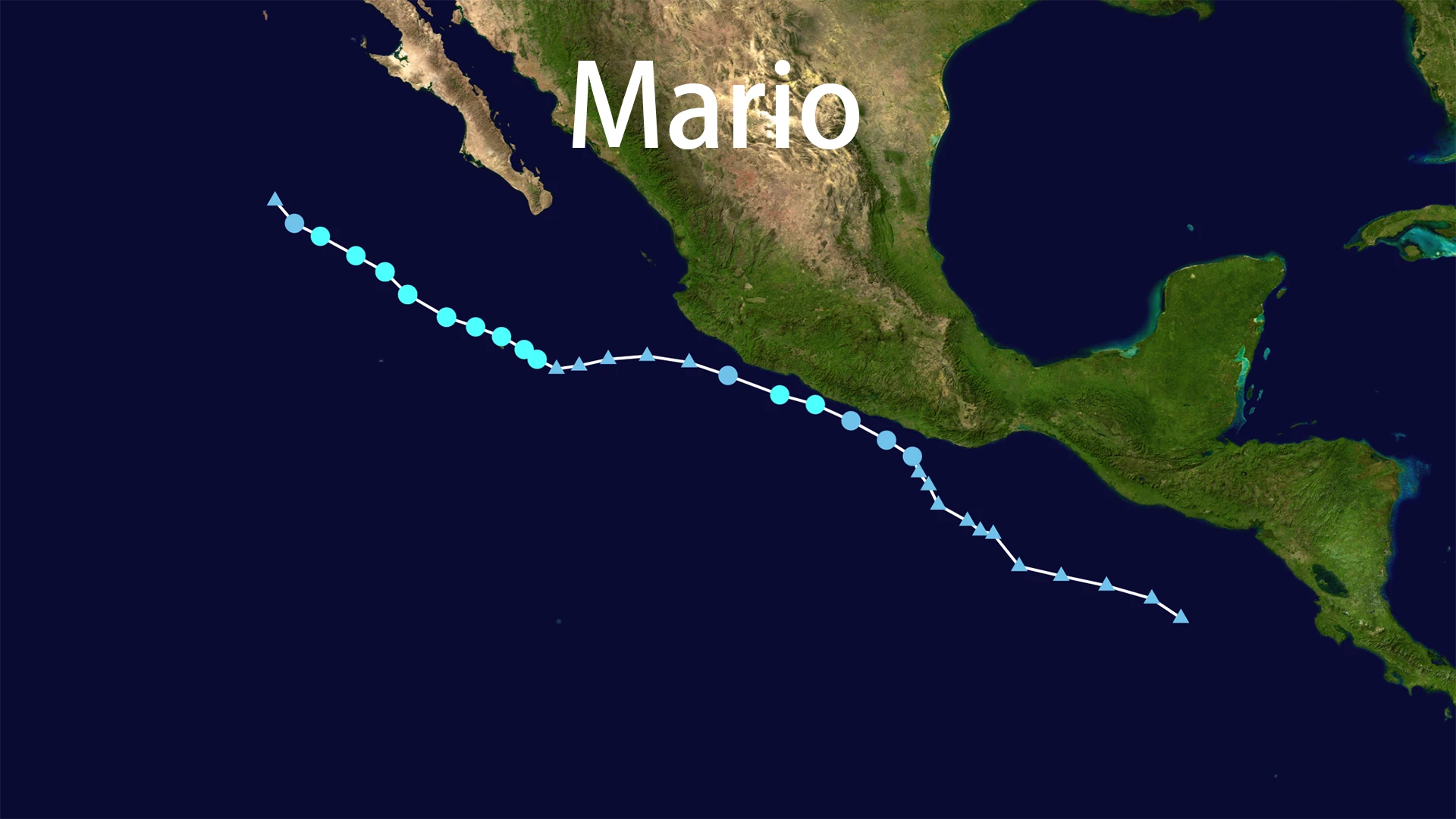
The journey of Tropical Storm Mario began conventionally enough. It developed from a tropical disturbance and was officially named on September 12, 2025, off the coast of southwestern Mexico. The National Hurricane Center (NHC) initially classified it as a "mini" storm—a compact system with tropical-storm-force winds extending only 25 miles from its center.
Initial forecasts suggested a short lifespan. As predicted, Tropical Storm Mario quickly encountered unfavorable conditions and weakened to a tropical depression within hours of being named. Most models indicated the system would fully dissipate over the open waters of the Pacific.
But Tropical Storm Mario had other plans.
In an unusual meteorological twist, the storm's low-level circulation persisted. By September 14, against all earlier predictions, the system had reorganized and regained tropical storm strength. This rebirth marked a critical turning point, allowing Tropical Storm Mario to gather and transport a massive amount of tropical moisture while moving parallel to the Baja California peninsula.
The true legacy of Tropical Storm Mario was written not in wind metrics but in rainfall totals and flood damage. While the storm's core winds remained over water, its abundant moisture created devastating impacts on land.
In Mexico's Baja California Peninsula, the relentless rainfall triggered what local officials described as "historically unprecedented" flash flooding. The city of Mulegé experienced particularly severe impacts, with 24-hour rainfall exceeding 150 mm (6 inches). The dry terrain couldn't absorb the deluge, leading to destructive flash floods that washed away roads and damaged critical infrastructure.
The impacts of Tropical Storm Mario extended far beyond Mexico. As the system weakened over cooler waters, its remnant moisture plume traveled northward into the American Southwest. This tropical connection fueled unusual late-summer thunderstorms across Southern California, Arizona, and Nevada, bringing flash flood risks to desert regions and even creating concerns about dry lightning potentially sparking wildfires.
Forecasting Challenges and Lessons Learned
The case of Tropical Storm Mario presented exceptional challenges for forecasters. Small-scale systems like Mario are particularly sensitive to subtle changes in atmospheric conditions, making them notoriously difficult to predict accurately.
The storm's unexpected reorganization highlighted limitations in existing weather models, which had initially predicted a straightforward dissipation. This forecasting challenge underscores the need for continued refinement in how models handle the complex interplay between small-scale circulations and their environment.
The event also emphasized the critical importance of communicating rainfall risks alongside wind threats. While Tropical Storm Mario never posed a major wind hazard, its precipitation potential was significantly underestimated in initial forecasts.
Key Meteorological Data
The following table summarizes essential facts about this remarkable weather event:
| Aspect | Detail |
|---|---|
| Peak Intensity | 65 mph (100 km/h) winds |
| Minimum Pressure | 993 mbar |
| Maximum Rainfall | 150+ mm (Baja California) |
| Primary Impact Zones | SW Mexico, Baja California, SW USA |
| Main Hazards | Flash flooding, mudslides, thunderstorms |
Conclusion: Rethinking Storm Preparedness
The story of Tropical Storm Mario offers valuable lessons for meteorologists, emergency managers, and the public. It demonstrates conclusively that even systems classified as "mini" or "weak" can produce devastating impacts through persistent rainfall and flooding.
This event highlights the need for a more nuanced approach to storm communication—one that emphasizes specific hazards like rainfall potential rather than focusing exclusively on wind categories. As climate patterns continue to evolve, the unusual behavior displayed by Tropical Storm Mario may become less exceptional, making these lessons increasingly relevant for future preparedness efforts.
The legacy of Tropical Storm Mario will endure not as a record-breaking cyclone, but as a powerful reminder that in weather systems, as in nature, size alone never tells the whole story.